Skip to search
Skip to main content
Skip to first result
Search
You Searched For
Extent of Digitization
Completely digitized
Genre
Maps
Subject (Geographic)
London (England)--Maps--Early works to 1800
Search Results
Published / Created:
[1780]
Call Number:
32 L84 1780
Container / Volume:
BRBL_00048
Image Count:
1
Resource Type:
Maps, Atlases & Globes
Description:
Engrav'd for Thortons New & Complete History & Survey of London & Westminster.
Publisher:
Alex. Hogg.,
Subject (Geographic):
London (England)--Maps--Early works to 1800
Found in:
Beinecke Rare Book and Manuscript Library > A New & Correct Plan of the Cities of London and Westminister, with the Borough of Southwark ...
Creator:
Published / Created:
1746
Call Number:
2002 Folio 94
Image Count:
1
Resource Type:
Maps, Atlases & Globes
Alternative Title:
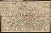
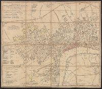
Contracted sketch of the plan of London &c. and Plan of the cities of London and Westminster and borough of Southwark.
Description:
"Published in October 1746 ... "
Publisher:
John Pine and John Tinney,
Subject (Geographic):
London (England)--Maps--Early works to 1800
Subject (Name):
Hodgson, Ralph,--1871-1962--Autograph
Found in:
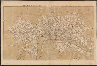
Beinecke Rare Book and Manuscript Library > A contracted scetch of the plan of London &c. : printed on 24 sheets of imperial paper, to shew the general appearance of the whole : for the use of those who bind it in a book, and for the better comprehension of the divisions mentioned in the index.
Published / Created:
1713]
Call Number:
38 P21 1713
Container / Volume:
BRBL_00160
Image Count:
1
Resource Type:
Maps, Atlases & Globes
Description:
By DeLisle.
Publisher:
I. Senex,
Subject (Geographic):
London (England)--Maps--Early works to 1800
Found in:
Beinecke Rare Book and Manuscript Library > A map of the provostship and vicounty of Paris.
Published / Created:
1750?]
Call Number:
32 L84 1750
Container / Volume:
BRBL_00048
Image Count:
1
Resource Type:
Maps, Atlases & Globes
Subject (Geographic):
London (England)--Maps--Early works to 1800
Found in:
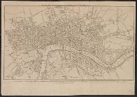
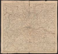
Beinecke Rare Book and Manuscript Library > A new and correct map of the countries twenty miles round London. By Thos. Bowen.
Published / Created:
1791
Call Number:
32 L84 1791
Container / Volume:
BRBL_00048
Image Count:
1
Resource Type:
Maps, Atlases & Globes
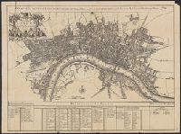
Description:
Tables of data, etc.
Publisher:
Robert Sayer,
Subject (Geographic):
London (England)--Maps--Early works to 1800
Found in:
Beinecke Rare Book and Manuscript Library > A new and correct plan of the cities of London, Westminster, and borough of Southwark ... 1791 ...
Published / Created:
1720
Call Number:
32 L84 1720
Container / Volume:
BRBL_00048
Image Count:
1
Resource Type:
Maps, Atlases & Globes
Description:
A plan of the City's of London, Westminster and Borough of Southwark; with the new Additional Buildings Anno. 1720.
Publisher:
Cassell & Company,
Subject (Geographic):
London (England)--Maps--Early works to 1800
Found in:
Beinecke Rare Book and Manuscript Library > A new map of London ... 1720 Revised by Ino. Senex. S. Parker Delin. et sculpt.
Published / Created:
[1800?]
Call Number:
32 L84 1800
Container / Volume:
BRBL_00048
Image Count:
1
Resource Type:
Maps, Atlases & Globes
Publisher:
Carington Bowles,
Subject (Geographic):
London (England)--Maps--Early works to 1800
Found in:
Beinecke Rare Book and Manuscript Library > A new map of the country twenty miles round London.
Published / Created:
1772
Call Number:
32 L84 1772
Container / Volume:
BRBL_00048
Image Count:
1
Resource Type:
Maps, Atlases & Globes
Subject (Geographic):
London (England)--Maps--Early works to 1800
Found in:
Beinecke Rare Book and Manuscript Library > A new plan of London Westminster and Southwark. Asby sculp. Engraved for Noortbouck History of London, 1772.
Creator:
Call Number:
32 L84 1766
Container / Volume:
BRBL_00048
Image Count:
1
Resource Type:
Maps, Atlases & Globes
Subject (Geographic):
London (England)--Maps--Early works to 1800 and Westminster (London, England)--Maps--Early works to 1800
Found in:
Beinecke Rare Book and Manuscript Library > A new plan of the city and liberty of Westminster ... / drawn & engraved by Thomas Jefferys ...
Creator:
Published / Created:
1746
Call Number:
2002 Folio 94
Image Count:
24
Resource Type:
Maps, Atlases & Globes
Description:
Includes drawings of ships on the Thames, lists of abbreviations and London aldermen's names, and a statement of dedication to the mayor and aldermen of London.
Publisher:
John Pine & John Tinney,
Subject (Geographic):
London (England)--Maps--Early works to 1800, London Region (England)--Maps--Early works to 1800, Southwark (London, England)--Maps--Early works to 1800, and Westminster (London, England)--Maps--Early works to 1800
Subject (Name):
Hodgson, Ralph,--1871-1962--Autograph
Found in:
Beinecke Rare Book and Manuscript Library > A plan of the cities of London and Westminster, and borough of Southwark, with the contiguous buildings / from an actual survey, taken by John Rocque, land-surveyor, and engraved by John Pine ...