Skip to search
Skip to main content
Skip to first result
Search
You Searched For
Extent of Digitization
Completely digitized
Genre
Maps
Subject (Geographic)
Netherlands
Search Results
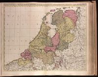
Creator:
Published / Created:
1st of January, 1789.
Call Number:
1982 Folio 10
Image Count:
1
Description:
BEIN 1982 Folio 10: Armorial bookplate: Charles Abbot. No. 10 of 42 maps bound together.
Publisher:
William Faden
Subject (Geographic):
Netherlands
Found in:
Beinecke Rare Book and Manuscript Library > A map of the seven united provinces, with the land of Drent, and the generality Lands
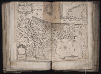
Creator:
Published / Created:
ca. 1702?]
Call Number:
1973 Folio 18
Image Count:
1
Description:
BEIN 1973 Folio 18: Backed with paper. Ms. no. "40" in upper-right corner. Sheet measures 53.6 x 63.0 cm. No. 39 of 87 maps bound together.
Publisher:
Gerard Valk
Subject (Geographic):
Netherlands
Found in:
Beinecke Rare Book and Manuscript Library > Belgica Foederata complectens septem Provincias, Ducatum Geldriae, Comitatus Hollandiae et Zelandiae, Dioeceses Trajectum, Transisulaniam, Groningam, et Frisiam, et circumjacentes Provincias [cartographic material]
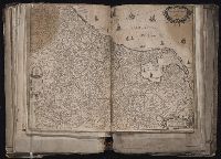
Creator:
Published / Created:
1720?]
Call Number:
1975 Folio 31
Image Count:
1
Description:
BEIN 33 1700: Imperfect: Split into 2 pieces. Mounted on board. Sheet measures 51.3 x 59.7 cm.
Publisher:
Johann Baptist Homann
Subject (Geographic):
Netherlands, New York (State), and East Indies
Found in:
Beinecke Rare Book and Manuscript Library > Belgii pars septentrionalis communi nomine vulgo Hollandia nuncupata continens statum potentissimae Batavorum Reipublicea sev provincias VII foederatas
Creator:
Published / Created:
1747 [i.e. 1748?]
Call Number:
1975 Folio 31
Image Count:
1
Alternative Title:
Carte des XVII. provinces ou de l'Allemagne inferievre, dresseé suivant la projection stereographique, et appüyée par les mesures faites de Mess. Cassini, Snellius et Mouschenbrok, par Mr. Tob. Majer de la Societé geographique, et publiée par les Heritiers de Homann, l'An 1748
Description:
BEIN 1975 Folio 31: Sheet measures 53.3 x 61 cm. No. 11 of 42 maps bound together.
Publisher:
Cura et Studio Homannianorum Heredum
Subject (Geographic):
Benelux countries, Netherlands, Belgium, and Luxembourg
Found in:
Beinecke Rare Book and Manuscript Library > Belgii universi seu inferioris Germaniae quam XVII provinciae Austriaco Gallico et Batavo sceptro parentes constituunt nova tabula geographica
Creator:
Published / Created:
[1647]
Call Number:
1983 Folio 19
Image Count:
1
Alternative Title:
Comitatvs Hollandiae nova descriptio
Description:
BEIN 1983 Folio 19: Imperfect: hole along folds, with some loss of text. Sheet measures 39.5 x 52 cm. Reinforced along edges with paper. No. 52 of 92 maps bound together.
Publisher:
Apud Joannem Janssonium
Subject (Geographic):
Netherlands
Found in:
Beinecke Rare Book and Manuscript Library > Comitatus Hollandiae nova descriptio
Creator:
Published / Created:
anno 1636.
Call Number:
1983 Folio 19
Image Count:
1
Resource Type:
cartographic image
Alternative Title:
Hollandia comitatvs
Description:
BEIN 331 1636: Sheet measures 41.3 x 53.7 cm. With watermarks.
Publisher:
Apud Cornelio Dankero
Subject (Geographic):
Netherlands
Found in:
Beinecke Rare Book and Manuscript Library > Hollandia comitatus
Creator:
Published / Created:
[1690?]
Call Number:
1973 Folio 10
Image Count:
1
Description:
BEIN 1973 Folio 10: Sheets joined measure 81 x 62 cm. Bookplate of José M. Rodriguez. No. 44 of 63 maps bound together.
Publisher:
Nicolaes Visscher
Subject (Geographic):
Netherlands
Found in:
Beinecke Rare Book and Manuscript Library > Hollandiae Comitatus in ejusdem subjacentes ditiones : una cum toto ultrjectino dominio, nec non maximus partibus Geldriae Ducatus, Frisiae Comitatus, aliarumq[ue] vicinarum provinciarum foederatarum
Creator:
Published / Created:
1652.
Call Number:
1983 Folio 19
Image Count:
1
Alternative Title:
Nova 17 provinciarum discriptio and Nova XVII provinciarvm discriptio
Description:
BEIN 1983 Folio 19: Imperfect: torn and repaired along folds and in corners, with some loss of text. Sheet measures 38.8 x 54.8 cm. Reinforced along edges with manuscript waste. No. 50 of 92 maps bound together.
Publisher:
Apud Frederico de Widt
Subject (Geographic):
Netherlands
Found in:
Beinecke Rare Book and Manuscript Library > Nova XVII provinciarum discriptio
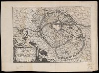
Published / Created:
1673.
Call Number:
Small 331 M112 1673
Image Count:
2
Subject (Geographic):
Netherlands
Found in:
Beinecke Rare Book and Manuscript Library > Plan de la Ville et des Attaques de Mastricht. Assiegee par l'Armee du Roy tres Chretien Louis le Grand Commandee par sa Majeste en personne le 17. juin 1673, et reduite a son obeis-sance le 30. du meme mois
Creator:
Published / Created:
a. 1748.
Call Number:
1973 Folio 30
Image Count:
2
Alternative Title:
Septem provinciae seu Belgivm Foederatvm quod generaliter Hollandia
Description:
BEIN 1973 Folio 30: Sheet measures 53.9 x 61.6 cm. No. 12 of 32 maps bound together.
Publisher:
Edentibus Homannianis Heredibus
Subject (Geographic):
Netherlands
Found in:
Beinecke Rare Book and Manuscript Library > Septem provinciae seu Belgium Foederatum quod generaliter Hollandia : audit speciali mappa delineatum adhibitis auxilium observationibus astronomieis nec non mensurationibus Snellii, Muschenbrokii, etc