Europe--Iberian Peninsula, Iberian Peninsula--Maps--Early works to 1800., Portugal, Portugal--Maps--Early works to 1800., Spain, and Spain--Maps--Early works to 1800.
Subject (Name):
Benedictines, Benedictines--Iberian Peninsula--Maps--Early works to 1800, Benedictines--Portugal--Maps--Early works to 1800, Benedictines--Spain--Maps--Early works to 1800, Catholic C, and Catholic Church
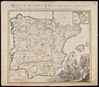
Carte general d ́Espagne et de Portugal diviseé en ses provinces actuelles par D.T. Lopez, nouvellement dressée par F.L.G. à Nuremberg chez les Heret. de Homann l ́an 1782
Description:
BEIN 39 1782: Imperfect: top edge chewed, with no loss of text. Sheet measures 54.6 x 61.3 cm.
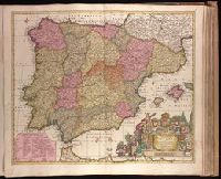
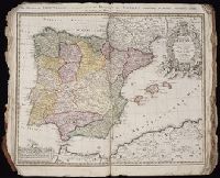
Regnorvm Hispaniae et Portvgalliae tabula generalis de l'Isliana and Reyno de Espanna dividido en dos grandes estados de Aragón y de Castilla, subdividido en muchas provincias donde se halla también el Reyno de Portugal
Description:
BEIN 1973 Folio 30: Imperfect: torn along fold, with no loss of text. Sheet measures 53.9 x 62 cm. No. 5 of 32 maps bound together.
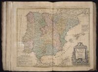
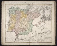
Reyno de Espanna dividido en dos grandes estados de Aragón y de Castilla, subdividido en muchas provincias donde se halla también el Reyno de Portvgal
Description:
BEIN 1975 Folio 31: Imperfect: torn along fold and frayed along edges, with no loss of text. Sheet measures 53.2 x 60.7 cm. No. 4 of 42 maps bound together.
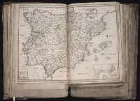
Spain distinguisht into all its kingdoms, principalities & c., that is to say under the dominion of the Catholick king viz. the kingdom of Castile, Leon, Galicia ... described by Sanson, corrected and amended by William Berry
Description:
BEIN 1973 Folio 10: Sheet measures 61.3 x 96.7 cm. Bookplate of José M. Rodriguez. No. 10 of 63 maps bound together.
Publisher:
Sold by William Berry at the signe of the Globe between Chering Cross and White Hall