Skip to search
Skip to main content
Skip to first result
Search
You Searched For
Extent of Digitization
Completely digitized
Genre
Maps
Subject (Name)
Roeser, C. (Charles)
New Search
Search Results
Creator:
Published / Created:
[1878?].
Call Number:
75 1878
Container / Volume:
BRBL_00406
Image Count:
16
Resource Type:
Maps, Atlases & Globes
Alternative Title:
Centennial map of the United States and territories and Centennial map of the United States, 1879.
Description:
Imperfect: Sheet 5 wanting., In portfolio., and Relief shown by hachures.
Publisher:
J. Bien,
Subject (Geographic):
United States--Maps
Subject (Name):
Bien, Julius, 1826-1909, Roeser, C. (Charles), United States. General Land Office, and Woods, William L
Found in:
Beinecke Rare Book and Manuscript Library > 1876 Centennial map of the United States and territories : showing the extent of public surveys, indian and military reservations, land grant R.R. rail roads, canals, cities, towns & other details / compiled from the official surveys of the General Land O
Creator:
Published / Created:
1879
Call Number:
826 1879
Container / Volume:
BRBL_00577
Image Count:
1
Resource Type:
Maps, Atlases & Globes
Description:
Includes dates of treaties with Indian nations., Library's copy annotated in black ink., Prime meridians: Washington and Greenwich., Relief shown by hachures., and Shows wagon roads, trails, railroads and natural features.
Publisher:
General Land Office,
Subject (Geographic):
Indian Territory--Maps
Subject (Name):
Roeser, C. (Charles)
Found in:
Beinecke Rare Book and Manuscript Library > Indian Territory, 1879 / compiled from the official records of the General Land Office and other sources by C. Roeser, Principal Draughtsman.
Creator:
Published / Created:
1876
Call Number:
75 1876
Container / Volume:
BRBL_00405
Image Count:
6
Resource Type:
Maps, Atlases & Globes
Description:
Insets: Alaska and Aleutian Islands. and Relief shown by hachures.
Publisher:
Photolith. and printed by J. Bien,
Subject (Name):
Bien, Julius, 1826-1909 and Roeser, C. (Charles)
Subject (Topic):
Canals--United States--Maps, Indian reservations--United States--Maps, Military reservations--United States--Maps, Railroad land grants--United States--Maps, Railroads--United States--Maps, and Surveying-
Found in:
Beinecke Rare Book and Manuscript Library > Map of the United States and territories, showing the extent of public surveys, Indian and military reservations, land grant R.R., rail roads, canals, and other details / compiled from the official surveys of the General Land Office, and other authentic s
Creator:
Published / Created:
1879
Call Number:
831 1879
Container / Volume:
BRBL_00579
Image Count:
1
Resource Type:
Maps, Atlases & Globes
Description:
Prime meridians: Greenwich and Washington. and Relief shown by hachures.
Publisher:
General Land Office,
Subject (Geographic):
Montana--Maps
Subject (Name):
Bien, Julius, 1826-1909 and Roeser, C. (Charles)
Found in:
Beinecke Rare Book and Manuscript Library > Montana Territory / compiled from the official records of the General Land Office and other sources by C. Roeser, principal draughtsman G.L.O.
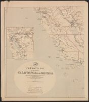
Creator:
Published / Created:
1883
Call Number:
844gmd 1883
Container / Volume:
BRBL_00618
Image Count:
4
Resource Type:
Maps, Atlases & Globes
Description:
Includes inset of the San Francisco Bay area.
Publisher:
The Office,
Subject (Name):
Roeser, C. (Charles)
Subject (Topic):
Postal service--California--Maps and Postal service--Nevada--Maps
Found in:
Beinecke Rare Book and Manuscript Library > Post route map of the states of California and Nevada : showing Post Offices with the intermediate distances between them and mail routes in operation on 1st October 1883 / published by order of Postmaster General Walter Q. Gresham under the direction of
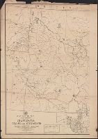
Creator:
Published / Created:
[1883]
Call Number:
831gmd 1883
Container / Volume:
BRBL_00581
Image Count:
2
Resource Type:
Maps, Atlases & Globes
Publisher:
The Dept.,
Subject (Name):
Roeser, C. (Charles)
Subject (Topic):
Postal service--Idaho--Maps, Postal service--Montana--Maps, and Postal service--Wyoming--Maps
Found in:
Beinecke Rare Book and Manuscript Library > Post route map of the territories of Montana, Idaho, and Wyoming with parts of adjacent states and territories : showing post offices with intermediate distances between them and mail routes in operation on 1st October 1883 / published by order of Postmas
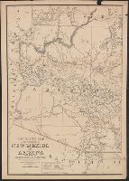
Creator:
Published / Created:
1883
Call Number:
842gmd 1883
Container / Volume:
BRBL_00600
Image Count:
2
Resource Type:
Maps, Atlases & Globes
Description:
Relief shown by hachures.
Publisher:
The Dept.,
Subject (Geographic):
Arizona--Maps and New Mexico--Maps
Subject (Name):
Roeser, C. (Charles)
Subject (Topic):
Postal service--Arizona--Maps and Postal service--New Mexico--Maps
Found in:
Beinecke Rare Book and Manuscript Library > Post route map of the territories of New Mexico and Arizona : with parts of adjacent states and territories, showing post offices with the intermediate distances between them and mail routes in operation on 1st October 1883 / published by order of Postmas
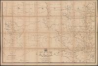
Creator:
Published / Created:
1883
Call Number:
821gmd 1883
Container / Volume:
BRBL_00566
Image Count:
2
Resource Type:
Maps, Atlases & Globes
Description:
Contains explanation of mail service.
Publisher:
U.S. Post Office Dept.,
Subject (Name):
Roeser, C. (Charles)
Subject (Topic):
Postal service--Dakota Territory--Maps, Postal service--North Dakota--Maps, and Postal service--South Dakota--Maps
Found in:
Beinecke Rare Book and Manuscript Library > Post route map of the territory of Dakota with adjacent parts of Montana, Wyoming, Nebraska, Iowa and Minnesota : and portions of the Dominion of Canada, showing post offices with the intermediate distances between them and mail routes in operation on 1st
Creator:
Published / Created:
1883
Call Number:
836gmd 1883
Container / Volume:
BRBL_00593
Image Count:
1
Resource Type:
Maps, Atlases & Globes
Description:
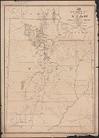
Also shows county boundaries and post routes reflect frequency of delivery. and Prime meridian: Washington.
Publisher:
Post Office Dept.,
Subject (Geographic):
Arizona--Maps
Subject (Name):
Roeser, C. (Charles)
Subject (Topic):
Postal service--Arizona--Maps
Found in:
Beinecke Rare Book and Manuscript Library > Post route map of the territory of Utah : with parts of adjacent states and territories / published by order of Postmaster General Walter Q. Gresham, under the direction of C.Roeser, Jr., topographer, P.O. Dept.
Creator:
Published / Created:
1878
Call Number:
793 1878
Container / Volume:
BRBL_00520
Image Count:
1
Resource Type:
Maps, Atlases & Globes
Description:
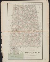
Scale : ca. 1:750,000.
Publisher:
The Office,
Subject (Geographic):
Alabama--Maps
Subject (Name):
Roeser, C. (Charles)
Found in:
Beinecke Rare Book and Manuscript Library > State of Alabama / compiled from the official records of the General Land Office and other sources by C. Roeser, principal draughtsman, G.L.O.
Branch:v1.65.8 ,Deployed:2025-04-02T07:25:52-04:00