Skip to search
Skip to main content
Skip to first result
Search
You Searched For
Extent of Digitization
Completely digitized
Genre
Maps
Subject (Topic)
Military bases--United States--Maps
Search Results
Creator:
Published / Created:
1864
Call Number:
75 1864
Container / Volume:
BRBL_00403
Image Count:
1
Resource Type:
Maps, Atlases & Globes
Alternative Title:
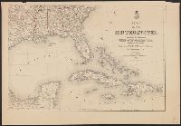
Railroad and military map of the United States, Mexico, the West Indies &c.
Description:
In upper left margin: No. 7.
Publisher:
J.H. Colton,
Subject (Geographic):
Central America--Maps, Mexico--Maps, United States--Maps, and West Indies--Maps
Subject (Topic):
Military bases--United States--Maps and Railroads--United States--Maps
Found in:
Beinecke Rare Book and Manuscript Library > Coltons' rail-road and military map of the United States, Mexico, the West Indies &c.
Creator:
Published / Created:
1889
Call Number:
75 1889
Container / Volume:
BRBL_00407
Image Count:
4
Resource Type:
Maps, Atlases & Globes
Description:
"1885. Corrected to December 1889."
Publisher:
The Office,
Subject (Geographic):
United States--Maps
Subject (Name):
United States. Army. Corps of Engineers. Engineer Office
Subject (Topic):
Military bases--United States--Maps
Found in:
Beinecke Rare Book and Manuscript Library > Map of the United States / prepared in the Office of the Chief of Engineers, U.S.A., by W.W. Winship, under the direction of Brig. Gen. John Newton, Chief of Eng., Bvt. Major General, U.S.A.
Creator:
Published / Created:
1870
Call Number:
75 1870A
Container / Volume:
BRBL_00404
Image Count:
4
Resource Type:
Maps, Atlases & Globes
Description:
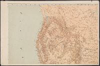
Insets: maps of the Territory of Alaska; [and] West Indies and Isthus of Darien.
Publisher:
Office of the Chief of Engineers, War Department,
Subject (Geographic):
United States--Maps
Subject (Name):
United States. War Dept
Subject (Topic):
Military bases--United States--Maps
Found in:
Beinecke Rare Book and Manuscript Library > Military map of the United States / compiled and drawn by E. Freyhold.
Creator:
Published / Created:
1941?]
Call Number:
11hd 1941S
Image Count:
2
Resource Type:
Maps, Atlases & Globes
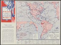
Alternative Title:
United States defense map and Western Hemisphere strategic bases and Western Hemisphere strategic bases
Description:
"Calendar of world events, 1935-1941"--Lower margin of second map.
Publisher:
Richfield [Oil Corp.,
Subject (Geographic):
United States--Defenses--Maps, United States--Maps, Western Hemisphere--Defenses--Maps, and Western Hemisphere--Maps
Subject (Topic):
Military bases--United States--Maps, Military bases--Western Hemisphere--Maps, World War, 1939-1945--Maps, and World War, 1939-1945--Western Hemisphere--Maps
Found in:
Beinecke Rare Book and Manuscript Library > U.S. defense map and Western Hemisphere strategic bases [cartographic material] : army camps, forts, flying fields, air bases, naval bases, mileage distances and flying times between important points, Panama Canal defenses, U.S. Navy patrol areas, propose