Skip to search
Skip to main content
Skip to first result
Search
You Searched For
Extent of Digitization
Completely digitized
Genre
Maps
Search Results
Published / Created:
[1775?]
Call Number:
76cea 1775
Container / Volume:
BRBL_00446
Image Count:
1
Resource Type:
Maps, Atlases & Globes
Description:
Insets: The Town of Boston in new England. A Chart of the Atlantic Ocean shewing the Situation of Nova Scotia with the respect to the British Isles.
Publisher:
I. Mount, T. Page & W. Mount,
Subject (Geographic):
New England--Maps--Early works to 1800
Found in:
Beinecke Rare Book and Manuscript Library > A Map of the Coast of New England from Staten Island of Breton; as if was actualy survey'd by Capt. Cyprian Southback.
Published / Created:
[1775?]
Call Number:
76cea 1775A
Container / Volume:
BRBL_00446
Image Count:
1
Resource Type:
Maps, Atlases & Globes
Description:
Insets: The Town of Boston in New England. A Chart of the Atlantic Ocean shewing the situation of Nova Scotia with respect to the British Isles.
Publisher:
I. Mount & T. Page & W. Mount, Tower Hill,
Subject (Geographic):
New England--Maps--Early works to 1800
Found in:
Beinecke Rare Book and Manuscript Library > A Map of the Coast of New England from Staten Island to the Island of Breton; as it was actualy survey'd by Capt Cyprian Southback.
Published / Created:
1798]
Call Number:
8045 1798B
Container / Volume:
BRBL_00546
Image Count:
1
Resource Type:
Maps, Atlases & Globes
Description:
Text: Fire Land so called It being a grant of 500,000 Acres by the Legislature of the State of Connecticut to certain sufferers in the late war with Britain it is presumed that the Eastern.
Subject (Geographic):
Western Reserve (Ohio)--Maps
Found in:
Beinecke Rare Book and Manuscript Library > A Map of the Connecticut Western Reserve, from actual Survey, By Seath Pease.
Published / Created:
1798
Call Number:
8045 1798A
Container / Volume:
BRBL_00546
Image Count:
1
Resource Type:
Maps, Atlases & Globes
Description:
Text: Fire Land so called It being a Grant of 500,000 Acres by the Legislature of the State of Connecticut to certain Sufferers in the late war with Britain.
Publisher:
Amos Doolittle,
Subject (Geographic):
Western Reserve (Ohio.)--Maps
Found in:
Beinecke Rare Book and Manuscript Library > A Map of the Connecticut Western Reserve, from actual Survey, by Seth Pease & Abn. Tappen.
Published / Created:
1795]
Call Number:
18 1795A
Container / Volume:
BRBL_00012
Image Count:
1
Resource Type:
Maps, Atlases & Globes
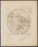
Description:
Engraved for Carey's Edition of Guthrie's Geography Improved.
Publisher:
Mathew Carey,
Subject (Geographic):
Arctic Regions--Maps--Early works to 1800
Found in:
Beinecke Rare Book and Manuscript Library > A Map of the Countries situate about the North Pole as far as the 50th Degree of North Latitude. W. Barker, sculp.
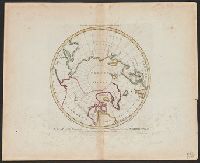
Published / Created:
1795]
Call Number:
18 1795
Container / Volume:
BRBL_00012
Image Count:
1
Resource Type:
Maps, Atlases & Globes
Description:
Engraved for Carey's Edition of Guthrie's Geography Improved.
Publisher:
Mathew Carey,
Subject (Geographic):
Arctic Regions--Maps--Early works to 1800
Found in:
Beinecke Rare Book and Manuscript Library > A Map of the Countries situate about the North Pole as far as the 50th Degree of North Latitude. W. Barker, sculp.
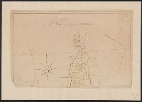
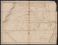
Published / Created:
[1770?]
Call Number:
771ad C38 1770
Container / Volume:
BRBL_00714
Image Count:
1
Resource Type:
Maps, Atlases & Globes
Description:
Color: pen and ink drawing with yellow detail., Lower half lacking., and Ms. cadastral map showing lands along Lake Champlain belonging to English soldiers.
Subject (Geographic):
New York--Maps, Manuscript--Early works to 1800
Found in:
Beinecke Rare Book and Manuscript Library > A Map of the County of Charlotte.
Published / Created:
1866
Call Number:
304 1866
Container / Volume:
BRBL_00033
Image Count:
1
Resource Type:
Maps, Atlases & Globes
Description:
Supplement to the Illustrated London News July 7, 1866.
Publisher:
Illustrated London News,
Subject (Geographic):
Europe, Central--Maps
Found in:
Beinecke Rare Book and Manuscript Library > A Map of the Germanic Confederation as it existed in June, 1866 and of Central Europe.
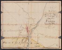
Published / Created:
1768
Call Number:
771 Al13 1768
Container / Volume:
BRBL_00713
Image Count:
2
Resource Type:
Maps, Atlases & Globes
Description:
Color: pen and ink, some yellow, blue and pink shading. and Notes: Clipping from Revolutionary war period, manuscript New York maps.
Subject (Geographic):
Albany (N.Y.)--Maps, Manuscript--Early works to 1800
Found in:
Beinecke Rare Book and Manuscript Library > A Map of the Lands Adjoining the Partition Line between Countys of Albany & Ulster Done of New York, 1768, Will Cockburn.
Published / Created:
1765
Call Number:
771 Al13 1765
Container / Volume:
BRBL_00713
Image Count:
2
Resource Type:
Maps, Atlases & Globes
Description:
Clipping from revolutionary war period manuscript New York maps. and Color: pen and ink drawing.
Subject (Geographic):
Albany (N.Y.)--Maps, Manuscript--Early works to 1800
Found in:
Beinecke Rare Book and Manuscript Library > A Map of the Lands on the Southside of the County of Albany between the Blue Mountains and the Sawkill. Surred in the month of Oct. 1765, by Will Cockburn.
Branch:v1.67.5 ,Deployed:2025-04-23T11:06:20-04:00