Skip to search
Skip to main content
Skip to first result
Search
You Searched For
Extent of Digitization
Completely digitized
Genre
Maps
Search Results
Published / Created:
[1774]
Call Number:
76 1774
Container / Volume:
BRBL_00443
Image Count:
2
Resource Type:
Maps, Atlases & Globes
Abstract:
Subject: Map of New England and Long Island with the states divided into cities and towns. Cartouche at lower right shows Liberty leading a Native American and pilgrims to Plymouth Rock.
Description:
"Observations on which this map is grounded.", Copy 2: Imperfect: southern sheet wanting., Includes compilation data and insets of "A plan of the town of Boston" and "A plan of the town of Boston Harbor from an accurate survey," ca. 1:150,000., and Prime meridia
Publisher:
November 29th 1774 Published according to Act by Thos. Jefferys geographer to His Royal Highness the Prince of Wales near Charing Cross,
Subject (Geographic):
Boston Harbor (Mass.)--Maps and New England--Maps
Subject (Name):
Jefferys, Thomas, -1771, publisher
Found in:
Beinecke Rare Book and Manuscript Library > A Map of the most inhabited part of New England [cartographic material] : containing the provinces of Massachusets Bay and New Hampshire with the colonies of Conecticut and Rhode Island divided into counties and townships : The whole composed from actual
Published / Created:
[1774]
Call Number:
76 1774
Container / Volume:
BRBL_00443
Image Count:
2
Resource Type:
Maps, Atlases & Globes
Abstract:
Subject: Map of New England and Long Island with the states divided into cities and towns. Cartouche at lower right shows Liberty leading a Native American and pilgrims to Plymouth Rock.
Description:
"Observations on which this map is grounded.", Copy 1: Dissected and mounted on linen., Includes compilation data and insets of "A plan of the town of Boston" and "A plan of the town of Boston Harbor from an accurate survey," ca. 1:150,000., and Prime meridian:
Publisher:
November 29th 1774 Published according to Act by Thos. Jefferys geographer to His Royal Highness the Prince of Wales near Charing Cross,
Subject (Geographic):
Boston Harbor (Mass.)--Maps and New England--Maps
Subject (Name):
Jefferys, Thomas, -1771, publisher
Found in:
Beinecke Rare Book and Manuscript Library > A Map of the most inhabited part of New England [cartographic material] : containing the provinces of Massachusets Bay and New Hampshire with the colonies of Conecticut and Rhode Island divided into counties and townships : The whole composed from actual
Published / Created:
[1795?]
Call Number:
51 50 A.D.
Container / Volume:
BRBL_00280
Image Count:
1
Resource Type:
Maps, Atlases & Globes
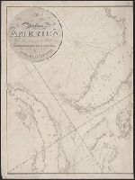
Subject (Geographic):
Palestine--Maps--Early works to 1800
Found in:
Beinecke Rare Book and Manuscript Library > A Map of those Countries in which the Apostles Travelled: in propagating Christianity. Compiled and Engraved by Joseph T. Scott.
Published / Created:
1797
Call Number:
771 N49 1797
Container / Volume:
BRBL_00484
Image Count:
1
Resource Type:
Maps, Atlases & Globes
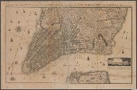
Description:
B. Taylor del. Roberts sculpt.
Subject (Geographic):
New York (N.Y.)--Maps--Early works to 1800
Found in:
Beinecke Rare Book and Manuscript Library > A New & Accurate Plan of the City of New York in the State of New York in North America. Published in 1797.
Published / Created:
[1790?]
Call Number:
3191 1790A
Container / Volume:
BRBL_00041
Image Count:
1
Resource Type:
Maps, Atlases & Globes
Description:
Copperplate rare Map printed in rose on white map hankerchief. Four corners have city views: London, Paris, Amsterdam, Dublin.
Subject (Geographic):
Great Britain--Maps--Early works to 1800
Found in:
Beinecke Rare Book and Manuscript Library > A New & Correct Map of Six Hundred Miles around London, with the Roads & Post Miles in England, Ireland & Scotland, and the Post Leagues in France.
Published / Created:
[1780]
Call Number:
32 L84 1780
Container / Volume:
BRBL_00048
Image Count:
1
Resource Type:
Maps, Atlases & Globes
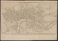
Description:
Engrav'd for Thortons New & Complete History & Survey of London & Westminster.
Publisher:
Alex. Hogg.,
Subject (Geographic):
London (England)--Maps--Early works to 1800
Found in:
Beinecke Rare Book and Manuscript Library > A New & Correct Plan of the Cities of London and Westminister, with the Borough of Southwark ...
Published / Created:
1818
Call Number:
755cea 1818
Container / Volume:
BRBL_00442
Image Count:
4
Resource Type:
Maps, Atlases & Globes
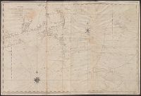
Subject (Geographic):
East (U.S.)--Maps--Early works to 1800
Found in:
Beinecke Rare Book and Manuscript Library > A New Chart of America, by Robt. Blachford. To His Excellency James Monroe ...
Published / Created:
[1821?]
Call Number:
7645cea 1821
Container / Volume:
BRBL_00463
Image Count:
1
Resource Type:
Maps, Atlases & Globes
Description:
Negative photostat of the 1st (1813) Edition of this map available.
Subject (Geographic):
Nantucket (Mass.)--Maps
Found in:
Beinecke Rare Book and Manuscript Library > A New Chart of Nantucket Shoals & George's Bank with the adjacent coast drawn from the latest authorities. 2nd Edition. By Samuel Lambert. Salem. Cushing, Appleton & S. Lambert, of the State of Mass. Corrected June 1821.
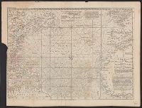
Published / Created:
1755
Call Number:
21 1755
Container / Volume:
BRBL_00014
Image Count:
1
Resource Type:
Maps, Atlases & Globes
Description:
2 copies.
Publisher:
London Magazine,
Subject (Geographic):
Atlantic Ocean--Maps--Early works to 1800
Found in:
Beinecke Rare Book and Manuscript Library > A New Chart of the Vast Atlantic Ocean; Exhibiting the Seat of War, both in Europe and America ...
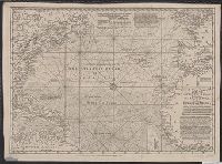
Branch:v1.67.5 ,Deployed:2025-04-23T11:06:15-04:00