Skip to search
Skip to main content
Skip to first result
Search
You Searched For
Extent of Digitization
Completely digitized
Repository
Beinecke Rare Book and Manuscript Library
Subject (Geographic)
Middle Atlantic States--Maps
Search Results
Creator:
Published / Created:
[1921?]
Call Number:
754gmb 1920
Container / Volume:
BRBL_00419
Image Count:
2
Resource Type:
Maps, Atlases & Globes
Alternative Title:
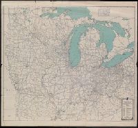
Automobile blue book.
Description:
"Should be used simultaneously with corresponding detailed directions published in the Automobile blue books."
Publisher:
Automobile Blue Books,
Subject (Geographic):
Middle Atlantic States--Maps and Middle West--Maps
Subject (Topic):
Automobile travel--Middle Atlantic States--Maps, Automobile travel--Middle West--Maps, Roads--Middle Atlantic States--Maps, and Roads--Middle West--Maps
Found in:
Beinecke Rare Book and Manuscript Library > General index map of Automobile blue book, volume 3.
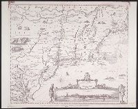
Published / Created:
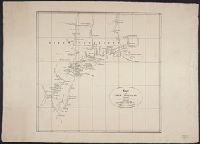
1827
Call Number:
755 1650B
Container / Volume:
BRBL_00422
Image Count:
1
Resource Type:
Maps, Atlases & Globes
Description:
From atlas "Venhandeling over de nederlandsche ontdekkingen in Amerika ... ", R.G. Bennet en J. van Wijk Roelandszoon, Utrecht, J. Altheer, 1827. Cf. Phillips, vol. 1, no. 3252.
Publisher:
J. Altheer,
Subject (Geographic):
Middle Atlantic States--Maps and New England--Maps
Found in:
Beinecke Rare Book and Manuscript Library > Kaart van Nieuw Nederland ... / van R.G. Bennet en J. van Wyk, Rz.
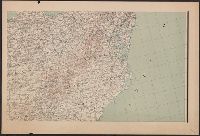
Published / Created:
1861
Call Number:
754 1861
Container / Volume:
BRBL_00416
Image Count:
1
Resource Type:
Maps, Atlases & Globes
Description:
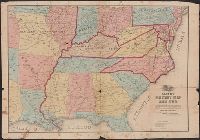
Insets: Map of the vicinity of Washington, Baltimore, Harper's Ferry ... ; Map of Richmond Va. & vicinity ; ... the Camp at Cairo ; Map of Norfolk Harbor, Fort Monroe, and vicinity ; Map of the Atlantic States showing the principal railroad connection...
Publisher:
L. Prang & Co.,
Subject (Geographic):
Middle Atlantic States--Maps, New England--Maps, and South Atlantic States--Maps
Found in:
Beinecke Rare Book and Manuscript Library > Map showing the R.R. Routes, Coast Lines, and Forts, between Boston & Norfolk Harbor.
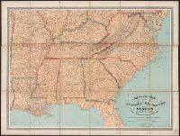
Creator:
Published / Created:
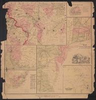
[1875?]
Call Number:
754 1875
Container / Volume:
BRBL_00417
Image Count:
1
Resource Type:
Maps, Atlases & Globes
Description:
General map of the southeastern states showing roads, railroads, cities and towns, rivers, and relief by hachures.
Publisher:
W. Schaus,
Subject (Geographic):
Middle Atlantic States--Maps, Middle West--Maps, Southern States--Maps, and United States--History--Civil War, 1861-1865--Maps
Found in:
Beinecke Rare Book and Manuscript Library > Military map of the middle and southern states showing the seat of war during the great rebellion in 1861 Drawn and engr. by J. Schedler ; Lith. of Sarony, Major & Knapp, N.Y.