Skip to search
Skip to main content
Skip to first result
Search
You Searched For
Extent of Digitization
Completely digitized
Subject (Geographic)
Alaska--Maps
Search Results
Creator:
Published / Created:
1906
Call Number:
848 1906
Container / Volume:
BRBL_00630
Image Count:
1
Resource Type:
Maps, Atlases & Globes
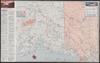
Description:
Insets: Aleutian Islands, Sitka, Juneau, Nome.
Publisher:
General Land Office,
Subject (Geographic):
Alaska--Maps
Subject (Name):
Andrew B. Graham Co, Bond, Frank, 1856-1940, Hendges, M, and United States. General Land Office
Found in:
Beinecke Rare Book and Manuscript Library > Alaska / compiled from the official records of the General Land Office, U.S. Coast and Geodetic Survey, Geological Survey, Canadian and other sources, under the direction of Frank Bond ; compiled by M. Hendges ; revised and drawn by Charles J. Helm.
Creator:
Published / Created:
1869
Call Number:
848 1869
Container / Volume:
BRBL_00630
Image Count:
1
Resource Type:
Maps, Atlases & Globes
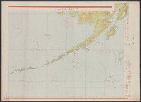
Description:
"No. 20"--Upper right margin.
Publisher:
U.S. Coast Survey,
Subject (Geographic):
Alaska--Maps and Yukon Territory--Maps
Subject (Name):
Dall, William Healey, 1845-1927 and Lindenkohl, H. (Henry)
Found in:
Beinecke Rare Book and Manuscript Library > Alaska and adjoining territory / drawn by H. Lindenkohl.
Creator:
Published / Created:
1898
Call Number:
848 C793 1898
Container / Volume:
BRBL_00632
Image Count:
1
Resource Type:
Maps, Atlases & Globes
Alternative Title:
Copper River and adjacent territory, Geological Survey (U.S.). Report, Public resolution ; no. 25, 55th Congress, 3d session., and Its Report, Public resolution ; no. 25, 55th Congress, 3d session
Description:
Contour interval approximately 250 feet.
Publisher:
The Survey,
Subject (Geographic):
Alaska--Maps, Chugach Mountains (Alaska)--Maps, and Copper River Region (Alaska)--Maps
Subject (Name):
Abercrombie, W. R.--(William Ralph),--b. 1857, Lowe, P. G, Mahlo, Emil, and Schrader, Frank C. (Frank Charles), 1860-1944
Found in:
Beinecke Rare Book and Manuscript Library > Alaska military expedition : in charge of Captain W.R. Abercrombie, U.S.A. Copper River and adjacent territory / topography by P.G. Lowe, F.C. Schrader, and Emil Mahlo.
Creator:
Published / Created:
[1949?]
Call Number:
848 1949
Container / Volume:
BRBL_00631
Image Count:
2
Resource Type:
Maps, Atlases & Globes
Alternative Title:
Access routes to Alaska., Golden heart of Alaska., and Great land, Alaska.
Description:
Date inferred from 1949 hunting info. on verso.
Publisher:
Northwest Mapping Service,
Subject (Geographic):
Alaska--Maps
Subject (Name):
Union Oil Company of California
Subject (Topic):
Roads--Alaska--Maps
Found in:
Beinecke Rare Book and Manuscript Library > Alaska road map and travel guide / [prepared for] Union Oil Company of California.
Published / Created:
Shōwa 18 [1943] and 昭和 18 [1943]
Call Number:
739CBF 1945 2
Container / Volume:
BRBL_00391
Image Count:
1
Resource Type:
Maps, Atlases & Globes
Alternative Title:
Japan. 陸地測量部., Japan. 陸軍. 参謀本部., and アンカレッヂ--ダッチハーバー / 陸地測量部, 参謀本部.
Description:
"Kōkūzu gunji himitsu (senchi ni arite wa 'bugaihi' to su) "
Publisher:
s.n.],
Subject (Geographic):
Alaska--Maps
Subject (Name):
Japan. Rikuchi Sokuryōbu and Japan. Rikugun. Sanbō Honbu
Subject (Topic):
Aeronautical charts--Alaska
Found in:
Beinecke Rare Book and Manuscript Library > Ankarejji--Datch Hābā / Rikuchi Sokuryōbu, Sanbō Honbu.
Branch:v1.70.9 ,Deployed:2025-10-15T09:50:15-04:00