Skip to search
Skip to main content
Skip to first result
Search
You Searched For
Extent of Digitization
Completely digitized
Subject (Geographic)
Middle Atlantic States--Maps
Search Results
Creator:
Published / Created:
[1921?]
Call Number:
754gmb 1920
Container / Volume:
BRBL_00419
Image Count:
2
Resource Type:
Maps, Atlases & Globes
Alternative Title:
Automobile blue book.
Description:
"Should be used simultaneously with corresponding detailed directions published in the Automobile blue books."
Publisher:
Automobile Blue Books,
Subject (Geographic):
Middle Atlantic States--Maps and Middle West--Maps
Subject (Topic):
Automobile travel--Middle Atlantic States--Maps, Automobile travel--Middle West--Maps, Roads--Middle Atlantic States--Maps, and Roads--Middle West--Maps
Found in:
Beinecke Rare Book and Manuscript Library > General index map of Automobile blue book, volume 3.
Published / Created:
1827
Call Number:
755 1650B
Container / Volume:
BRBL_00422
Image Count:
1
Resource Type:
Maps, Atlases & Globes
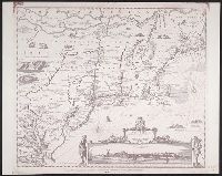
Description:
From atlas "Venhandeling over de nederlandsche ontdekkingen in Amerika ... ", R.G. Bennet en J. van Wijk Roelandszoon, Utrecht, J. Altheer, 1827. Cf. Phillips, vol. 1, no. 3252.
Publisher:
J. Altheer,
Subject (Geographic):
Middle Atlantic States--Maps and New England--Maps
Found in:
Beinecke Rare Book and Manuscript Library > Kaart van Nieuw Nederland ... / van R.G. Bennet en J. van Wyk, Rz.
Published / Created:
1861
Call Number:
754 1861
Container / Volume:
BRBL_00416
Image Count:
1
Resource Type:
Maps, Atlases & Globes
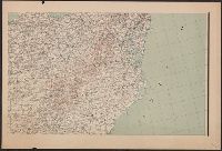
Description:
Insets: Map of the vicinity of Washington, Baltimore, Harper's Ferry ... ; Map of Richmond Va. & vicinity ; ... the Camp at Cairo ; Map of Norfolk Harbor, Fort Monroe, and vicinity ; Map of the Atlantic States showing the principal railroad connection...
Publisher:
L. Prang & Co.,
Subject (Geographic):
Middle Atlantic States--Maps, New England--Maps, and South Atlantic States--Maps
Found in:
Beinecke Rare Book and Manuscript Library > Map showing the R.R. Routes, Coast Lines, and Forts, between Boston & Norfolk Harbor.
Creator:
Published / Created:
[1875?]
Call Number:
754 1875
Container / Volume:
BRBL_00417
Image Count:
1
Resource Type:
Maps, Atlases & Globes
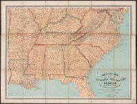
Description:
General map of the southeastern states showing roads, railroads, cities and towns, rivers, and relief by hachures.
Publisher:
W. Schaus,
Subject (Geographic):
Middle Atlantic States--Maps, Middle West--Maps, Southern States--Maps, and United States--History--Civil War, 1861-1865--Maps
Found in:
Beinecke Rare Book and Manuscript Library > Military map of the middle and southern states showing the seat of war during the great rebellion in 1861 Drawn and engr. by J. Schedler ; Lith. of Sarony, Major & Knapp, N.Y.
Branch:v1.70.9 ,Deployed:2025-11-12T15:33:18-05:00