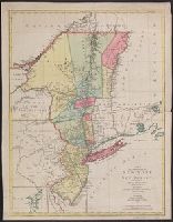
Subject: Map of the central part of the United States showing the middle Atlantic states, and the Ohio River Valley region. Includes anecdotes on the different Indian nations and the lands. Shows dates of settlements and agreements, locations of quarr...
Alternative Title:
Middle British colonies.
Description:
Differs from other copies in extension of the Connecticut River north beyond "Great Falls." Differs also in coloration of boundaries: Ohio River is colored as a boundary: Pennsylvania is shown as extending north to Lake Ontario, etc.
Publisher:
Printed for Carington Bowles,
Subject (Geographic):
Canada--Maps--Early works to 1800, Middle Atlantic States--Maps--Early works to 1800, Northeastern States--Maps--Early works to 1800, and Ohio River Valley--Maps--Early works to 1800
Subject (Name):
Bowles, Carington, 1724-1793, publisher
Subject (Topic):
British--America--Maps--Early works to 1800 and Chron.--1771
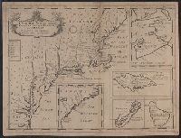
Appears in Edward Wells's A new sett of maps ..., various editions 1700-1738.
Subject (Geographic):
Barbados--Maps--Early works to 1800, Bermuda Islands--Maps--Early works to 1800, Jamaica--Maps--Early works to 1800, Middle Atlantic States--Maps--Early works to 1800, and Nova Scotia--Maps--Early works to 1800
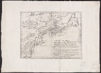
Italian version of Carte d'une partie de l'Amérique Septentrionale pour servir á l'intelligence du mémoire, London, 1755, delineating the boundary dispute between France and England over Nova Scotia. Shows historical French claims in Acadia.
Publisher:
[publisher not identified],
Subject (Geographic):
Middle Atlantic States--Maps--Early works to 1800, New England--Maps--Early works to 1800, and Nova Scotia--Maps--Early works to 1800
Subject (Name):
Bellin, Jacques Nicolas, 1703-1772. Carte d'une partie de l'Amérique Septentrionale pour servir á l'intelligence du mémoire. Italian
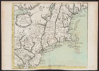
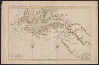
Neptune françois, ou, Atlas nouveau des cartes marines.
Description:
Appears in: Le Neptune françois, ou, Atlas nouveau des cartes marines, various eds.
Publisher:
Chez P. Mortier,
Subject (Geographic):
Middle Atlantic States--Maps--Early works to 1800
Subject (Name):
Mortier, Pierre
Subject (Topic):
Coasts, Coasts--Delaware--Maps--Early works to 1800, Coasts--Maryland--Maps--Early works to 1800, Coasts--New Jersey--Maps--Early works to 1800, and Nautical charts--Chesapeake Bay (Md. and Va.)--Early works to 1800