Skip to search
Skip to main content
Skip to first result
Search
You Searched For
Extent of Digitization
Completely digitized
Subject (Name)
Doolittle, A. J
Subject (Geographic)
Nevada--Maps
Search Results
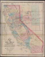
Creator:
Published / Created:
1863
Call Number:
844 1863
Container / Volume:
BRBL_00602
Image Count:
1
Resource Type:
Maps, Atlases & Globes
Description:
"Entered according to act of Congress in the year 1863 by Warren Holt ...."
Publisher:
W. Holt,
Subject (Geographic):
California--Maps and Nevada--Maps
Subject (Name):
Doolittle, A. J and Holt, Warren
Subject (Topic):
Mining districts--California--Maps and Mining districts--Nevada--Maps
Found in:
Beinecke Rare Book and Manuscript Library > A new map of the state of California and Nevada Territory : exhibiting the rivers, lakes, bays and islands, with the principal towns, roads, railroads, and transit routes to the silver mining districts of Nevada Territory ... / carefully compiled ... by L
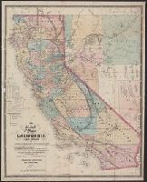
Creator:
Published / Created:
1867
Call Number:
844 1867
Container / Volume:
BRBL_00602
Image Count:
1
Resource Type:
Maps, Atlases & Globes
Description:
"Entered according to Act of Congress in the year 1869 by WarrenHolt, in the clerk's office of the District Court of the Northern District of the state of California."
Publisher:
W. Holt,
Subject (Geographic):
California--Maps and Nevada--Maps
Subject (Name):
Baker, Geo. H. (George Holbrook), 1827-1906, Doolittle, A. J, and Holt, Warren
Subject (Topic):
Mining districts--California--Maps and Mining districts--Nevada--Maps
Found in:
Beinecke Rare Book and Manuscript Library > A new map of the states of California and Nevada : exhibiting the rivers, lakes, bays, and islands, with the principal towns, roads, railroads, and transit routes to the silver mining districts; also meridian, standard, range and township lines as establi