Skip to search
Skip to main content
Skip to first result
Search
You Searched For
Extent of Digitization
Completely digitized
Access
Public
Subject (Geographic)
Virginia--Maps--Early works to 1800
Search Results
Creator:
Published / Created:
[1676]
Call Number:
755 1676D
Container / Volume:
BRBL_00423
Image Count:
2
Resource Type:
Maps, Atlases & Globes
Description:
Appears in Speed's The theatre of the Empire of Great Britaine.
Publisher:
Sold by Thomas Basset in Fleetstreet and Richard Chiswell in St. Pauls Church yard,
Subject (Geographic):
Maryland--History--Colonial period, ca. 1600-1775--Maps--Early works to 1800, Maryland--Maps--Early works to 1800, Virginia--History--Colonial period, ca. 1600-1775--Maps--Early works t, and Virginia--Maps--Early works to 1800
Subject (Name):
Bassett, Thomas, bookseller, Chiswell, Richard, Lamb, Francis, engraver, and Speed, John, 1552?-1629. Theatre of the Empire of Great Britaine
Found in:
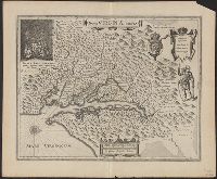
Beinecke Rare Book and Manuscript Library > A map of Virginia and Maryland / F. Lamb sculp.
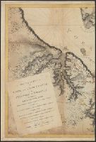
Creator:
Published / Created:
1794
Call Number:
783 1794
Container / Volume:
BRBL_00507
Image Count:
1
Resource Type:
Maps, Atlases & Globes
Description:
"Printed for Robt. Sayer at No. 53 in Fleet Street, London."
Publisher:
Laurie & Whittle,
Subject (Geographic):
Maryland--Maps, Middle Atlantic States--Maps--Early works to 1800, and Virginia--Maps--Early works to 1800
Subject (Name):
Jefferson, Peter, 1708-1757, Jefferys, Thomas, d. 1771, Robert Laurie and James Whittle, and Sayer, Robert, 1725-1794
Found in:
Beinecke Rare Book and Manuscript Library > A map of the most inhabited part of Virginia containing the whole province of Maryland with part of Pensilvania, New Jersey and North Carolina / drawn by Joshua Fry & Peter Jefferson in 1775.
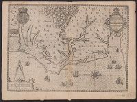
Creator:
Published / Created:
1590]
Call Number:
783 1580
Container / Volume:
BRBL_00691
Image Count:
1
Resource Type:
Maps, Atlases & Globes
Description:
Covers coastal region from Cape Fear to Chesapeake Bay.
Publisher:
De Brÿ,
Subject (Geographic):
North Carolina--Maps--Early works to 1800, Roanoke Colony--Maps--Early works to 1800, and Virginia--Maps--Early works to 1800
Subject (Name):
Bry, Theodor de, 1528-1598 and Hariot, Thomas, 1560-1621. Briefe and true report of the new found land of Virginia
Found in:
Beinecke Rare Book and Manuscript Library > Americae pars, nunc Virginia dicta : primum ab Anglis inuenta, sumtibus Dn. Walteri Raleigh, Equestris ordinis Viri, Anno D[omi]ni. MDLXXXV regni Vero Sereniss. nostrae Reginae Elisabethae XXVII, hujus vero Historia peculiari Libro descripta est, additis
Creator:
Published / Created:
[1630]
Call Number:
783 1630
Container / Volume:
BRBL_00507
Image Count:
1
Resource Type:
Maps, Atlases & Globes
Alternative Title:
Nova Virginiae tabvla
Description:
From Willem Janszoon Blaeu's Atlantis appendix ... Amsterdami : Apud Guiljelmum Blaeuw, 1630.
Publisher:
Ex Officina Guiljelmi Blaeuw,
Subject (Geographic):
Chesapeake Bay Region (Md. and Va.)--Maps--Early works to 1800, Maryland--Maps--Early works to 1800, and Virginia--Maps--Early works to 1800
Subject (Name):
Blaeu, Willem Janszoon, 1571-1638. Atlantis appendix, Gryp, Dirck, engraver, Powhatan, ca. 1550-1618, and Smith, John, 1580-1631
Subject (Topic):
Powhatan Indians--Pictorial works--Early works to 1800
Found in:
Beinecke Rare Book and Manuscript Library > Nova Virginiae tabula / DGrijp sculpt.