Skip to search
Skip to main content
Skip to first result
Search
You Searched For
Extent of Digitization
Completely digitized
Subject (Geographic)
World maps--Early works to 1800
Search Results
Creator:
Call Number:
11 1784
Container / Volume:
BRBL_00006
Image Count:
1
Resource Type:
Maps, Atlases & Globes
Description:
"On ignore si dans celle Parlie ce sont des Terres ou des Mers."
Subject (Geographic):
World maps--Early works to 1800
Found in:
Beinecke Rare Book and Manuscript Library > Carte réduite des parties connues du globe terrestre : dressée au dépost des cartes plans et journaux de la marine pour le service des vaisseaux du roy / par ordre de M. de Machault ... MDCCLV.
Published / Created:
1622]
Call Number:
70 1630
Container / Volume:
BRBL_00685
Image Count:
1
Resource Type:
Maps, Atlases & Globes
Description:
From Herrera y Tordesillas's Descripción de las Indias Occidentales ... Amstelodami : Apud M. Colinium, 1622.
Publisher:
Michiel Colijn,
Subject (Geographic):
World maps--Early works to 1800
Subject (Name):
Colijn, Michiel, Herrera y Tordesillas, Antonio de, d. 1625. Descripción de las Indias Occidentales. Latin, and Portugal.--Treaties, etc.--Spain--(1494 June 7)
Found in:
Beinecke Rare Book and Manuscript Library > Descripcion de las Yndias Ocidentalis [cartographic material].
Published / Created:
1704
Call Number:
11 1704
Container / Volume:
BRBL_00004
Image Count:
1
Resource Type:
Maps, Atlases & Globes
Description:
Shows the two hemispheres in streographic projections, and below, each hemisphere in three views in orthographica projections.
Publisher:
P. Moullart-Sanson,
Subject (Geographic):
World maps--Early works to 1800
Found in:
Beinecke Rare Book and Manuscript Library > Hemisphere occidental du globe terrestre ... Hemisphere oriental du globe terrestre ... par le Sieur Pierre Moullart-Sanson ...
Creator:
Published / Created:
ca. 1489
Call Number:
Art Storage 1980 157
Image Count:
3
Description:
"Opus [fecit?] Henricus Martellus Germanus."
Subject (Geographic):
World maps--Early works to 1800
Found in:
Beinecke Rare Book and Manuscript Library > Map of the world of Christopher Columbus.
Creator:
Published / Created:
[1682?]
Call Number:
11 1700B
Container / Volume:
BRBL_00004
Image Count:
1
Resource Type:
Maps, Atlases & Globes
Description:
Copy of L'Isle's map published by Lotter.
Publisher:
Apud Tobiam Conradū Lotter, chalcographum et geogr.,
Subject (Geographic):
World maps--Early works to 1800
Found in:
Beinecke Rare Book and Manuscript Library > Mappa totius mundi : adornata juxta observationes ... / per Guilielmum de l'Isle, celeberrimum regis Galliae geographum.
Published / Created:
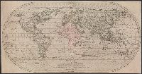
1782
Call Number:
11 1782
Container / Volume:
BRBL_00681
Image Count:
1
Resource Type:
Maps, Atlases & Globes
Alternative Title:
Carte générale de l'univers and Mappe-Mond
Description:
Map in oval form.
Publisher:
[s.n.],
Subject (Geographic):
World maps--Early works to 1800
Subject (Name):
Cook, James,--1728-1779--Travel--Maps--To 1800 and Lotter, Matthäus Albrecht, 1741-1810
Subject (Topic):
World maps--Early works to 1800
Found in:
Beinecke Rare Book and Manuscript Library > Mappe-Monde, ou, Carte générale de l'univers : sur une projection nouvelle d'une sphère ovale pour mieux entendre les distances entre L'Europe et Amerique avec le tour du monde du Lieut. Cook et tous les découvertes nouvelles / dessinée et gravée pa
Branch:v1.70.9 ,Deployed:2025-11-12T16:01:11-05:00