Search
You Searched For
Search Results
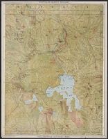
- Creator:
- Poole Brothers
- Published / Created:
- 1900?], c1898.
- Call Number:
- 833fcm Y38 1898
- Container / Volume:
- BRBL_00585
- Image Count:
- 2
- Resource Type:
- Maps, Atlases & Globes
- Alternative Title:
- Yellowstone National Park, Puget Sound, and Alaska, via Northern Pacific Railway
- Description:
- 2 maps, text, distance table, and ill. on verso.
- Publisher:
- Poole Bros.?,
- Subject (Geographic):
- Yellowstone National Park--Maps
- Subject (Name):
- Northern Pacific Railway Company
- Found in:
- Beinecke Rare Book and Manuscript Library > The Yellowstone National Park, via Northern Pacific Railway.
- Creator:
- Geological Survey (U.S.)
- Published / Created:
- [1912]
- Call Number:
- 833fcm Y38 1912
- Container / Volume:
- BRBL_00585
- Image Count:
- 1
- Resource Type:
- Maps, Atlases & Globes
- Alternative Title:
- Yellowstone National Park, Wyoming-Montana-Idaho
- Description:
- Contour interval 100 feet. Datum is mean sea level.
- Publisher:
- Engraved and printed by the U.S. Geological Survey,
- Subject (Geographic):
- Yellowstone National Park--Maps
- Found in:
- Beinecke Rare Book and Manuscript Library > Topographic map of the Yellowstone National Park, Wyoming-Montana-Idaho / from Geological Survey atlas sheets surveyed in 1883-85 ; partial revision in 1910 by E.P. Davis ; R.B. Marshall, chief geographer.
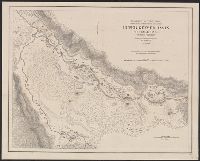
- Creator:
- Hergesheimer, E. (Edwin)
- Published / Created:
- 1871
- Call Number:
- 833 Y38 1871D
- Container / Volume:
- BRBL_00584
- Image Count:
- 1
- Resource Type:
- Maps, Atlases & Globes
- Description:
- At head of title: Department of the Interior, U.S. Geological Survey of the Territories.
- Publisher:
- Geological Survey of the Territories,
- Subject (Geographic):
- Yellowstone National Park--Maps
- Subject (Name):
- Geological Survey of the Territories (U.S.), Hayden, F. V. (Ferdinand Vandeveer), 1829-1887, and Schönborn, A
- Subject (Topic):
- Geysers--Wyoming--Maps
- Found in:
- Beinecke Rare Book and Manuscript Library > Upper Geyser Basin, Fire Hole River, Wyoming Territory / surveyed by the party in charge of F.V. Hayden ; compiled and drawn from field notes and sketches of A. Schönborn by E. Hergesheimer.
- Creator:
- Hergesheimer, E. (Edwin)
- Published / Created:
- [1872]
- Call Number:
- 833 Y38 1871B
- Container / Volume:
- BRBL_00584
- Image Count:
- 1
- Resource Type:
- Maps, Atlases & Globes
- Description:
- "1871."
- Publisher:
- Geological Survey of the Territories,
- Subject (Geographic):
- Yellowstone Lake (Wyo.)--Maps and Yellowstone National Park--Maps
- Subject (Name):
- Elliott, Henry Wood, 1846-1930, Geological Survey of the Territories (U.S.), Hayden, F. V. (Ferdinand Vandeveer), 1829-1887, and Schönborn, A
- Found in:
- Beinecke Rare Book and Manuscript Library > Yellowstone Lake, Wyoming Territory / surveyed by the party in charge of F.V. Hayden ; compiled and drawn by E. Hergesheimer from field notes and sketches of A. Schönborn & H.W. Elliott.
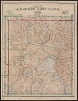
- Creator:
- Berthrong, I. P
- Published / Created:
- [1911]
- Call Number:
- 833fcm Y38 1911
- Container / Volume:
- BRBL_00585
- Image Count:
- 1
- Resource Type:
- Maps, Atlases & Globes
- Description:
- Relief shown by shading and spot heights.
- Publisher:
- General Land Office,
- Subject (Geographic):
- Yellowstone National Park--Maps
- Subject (Name):
- Eckert Lithographing Company, Helm, Charles J, and United States. General Land Office
- Found in:
- Beinecke Rare Book and Manuscript Library > Yellowstone National Park / compiled from the official records of the General Land Office, U.S. Geological Survey and other sources, under the direction of I.P. Berthrong, Chief of Drafting Division, G.L.O., 1911 ; compiled and drawn by I.P. Berthrong ; l
- Creator:
- Heubach, Emil
- Published / Created:
- 1881
- Call Number:
- 833fcm Y38 1881
- Container / Volume:
- BRBL_00585
- Image Count:
- 1
- Resource Type:
- Maps, Atlases & Globes
- Description:
- Relief shown by hachures.
- Publisher:
- Office of the Chief of Engineers, U.S.A.,
- Subject (Geographic):
- Yellowstone National Park--Maps
- Subject (Name):
- United States. Army. Corps of Engineers
- Found in:
- Beinecke Rare Book and Manuscript Library > Yellowstone National Park, Big Horn Mountains and adjacent territory / prepared in Office of Chief Engineer, Mil. Div. Mo. 1881 ; Emil Heubach, draughtsman.
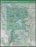
- Creator:
- National Geographic Society (U.S.). Cartographic Division
- Published / Created:
- c1989.
- Call Number:
- 833 Y38 1989
- Container / Volume:
- BRBL_00584
- Image Count:
- 2
- Resource Type:
- Maps, Atlases & Globes
- Alternative Title:
- Special places of the world map series
- Description:
- "Supplement to the National Geographic, February 1989, page 216A, vol. 175, no.2-Yellowstone/Grand Teton."
- Publisher:
- The Society,
- Subject (Geographic):
- Grand Teton National Park (Wyo.)--Maps and Yellowstone National Park--Maps
- Subject (Name):
- Garver, John B
- Found in:
- Beinecke Rare Book and Manuscript Library > Yellowstone and Grand Teton / produce by the Cartographic Division, National Geographic Society ; John B. Garver, Jr., chief cartographer.