Skip to search
Skip to main content
Skip to first result
Search
You Searched For
Extent of Digitization
Completely digitized
Subject (Name)
United States. Army Map Service
Search Results
Creator:
Published / Created:
1943
Call Number:
40 R19 1943
Container / Volume:
BRBL_00215
Image Count:
1
Resource Type:
Maps, Atlases & Globes
Alternative Title:
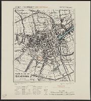
Geographical Section, General Staff ; no. 4380, GSGS (Series) ; 4380., and Italy
Description:
"12/42/G.S.G.S."
Publisher:
Army Map Service, U.S. Army,
Subject (Geographic):
Ravenna (Italy)--Maps
Subject (Name):
United States. Army Map Service
Found in:
Beinecke Rare Book and Manuscript Library > Town plan of Ravenna [cartographic material].
Creator:
Published / Created:
1943
Call Number:
408 Sy76 1943
Container / Volume:
BRBL_00239
Image Count:
1
Resource Type:
Maps, Atlases & Globes
Alternative Title:
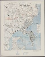
Geographical Section, General Staff ; no. 4379, GSGS (Series) ; 4379., Sicily 1:7,500, and Sicily 1:7,500, town plan of Siracusa
Description:
"Contours at 10 metres interval."
Publisher:
Army Map Service, U.S. Army,
Subject (Geographic):
Syracuse (Italy)--Maps
Subject (Name):
United States. Army Map Service
Found in:
Beinecke Rare Book and Manuscript Library > Town plan of Siracusa [cartographic material] / photolithographed by the Ordnance Survey, 1943.
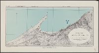
Creator:
Published / Created:
1943
Call Number:
679 T15 1943
Container / Volume:
BRBL_00349
Image Count:
1
Resource Type:
Maps, Atlases & Globes
Alternative Title:
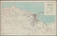
Geographical Section, General Staff ; no. 4241 and GSGS (Series) ; 4241.
Description:
"Contours at 5 metres interval."
Publisher:
Army Map Service, U.S. Army,
Subject (Geographic):
Tangier (Morocco)--Maps
Subject (Name):
United States. Army Map Service
Found in:
Beinecke Rare Book and Manuscript Library > Town plan of Tangier.
Published / Created:
[1942?]
Call Number:
679 T15 1942
Container / Volume:
BRBL_00349
Image Count:
1
Resource Type:
Maps, Atlases & Globes
Alternative Title:
Geographical Section, General Staff ; no. 4241 and GSGS (Series) ; 4241.
Description:
"Contours at 5 metres interval."
Publisher:
s.n.,
Subject (Geographic):
Tangier (Morocco)--Maps
Subject (Name):
United States. Army Map Service
Found in:
Beinecke Rare Book and Manuscript Library > Town plan of Tangier.
Creator:
Published / Created:
1943
Call Number:
40 T17 1943
Image Count:
1
Resource Type:
Maps, Atlases & Globes
Alternative Title:
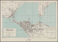
Great Britain. Army. Middle East Forces. M.D.R ; 539., GSGS (Series) ; 4380., Italy 1:10,000, Italy 1:10,000, town plan of Taranto, and Provisional GSGS (Middle East) ; 4380
Description:
"8-43."
Publisher:
Army Map Service, U.S. Army,
Subject (Geographic):
Taranto (Italy)--Maps
Subject (Name):
United States. Army Map Service
Found in:
Beinecke Rare Book and Manuscript Library > Town plan of Taranto [cartographic material] / reproduced by 512 Fd. Survey Coy., R.E., June, 1943, from W.O. pulls 1st edition, 1942, with revision from air photographs, dated 1943.
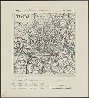
Creator:
Published / Created:
1943
Call Number:
40 T729 1943
Image Count:
1
Resource Type:
Maps, Atlases & Globes
Alternative Title:
Geographical Section, General Staff ; no. 4380, GSGS (Series) ; 4380., Italy, and Italy, town plan of Treviso
Description:
"12/42/G.S.G.S."
Publisher:
Army Map Service, U.S. Army,
Subject (Geographic):
Treviso (Italy)--Maps
Subject (Name):
United States. Army Map Service
Found in:
Beinecke Rare Book and Manuscript Library > Town plan of Treviso [cartographic material].
Creator:
Published / Created:
1943
Call Number:
40 Ud5 1943
Image Count:
1
Resource Type:
Maps, Atlases & Globes
Alternative Title:
Geographical Section, General Staff ; no. 4380, GSGS (Series) ; 4380., Italy, and Italy, town plan of Udine
Description:
"12/42/G.S.G.S."
Publisher:
Army Map Service, U.S. Army,
Subject (Geographic):
Udine (Italy)--Maps
Subject (Name):
United States. Army Map Service
Found in:
Beinecke Rare Book and Manuscript Library > Town plan of Udine [cartographic material].
Creator:
Published / Created:
1943
Call Number:
40 V652 1943
Image Count:
1
Resource Type:
Maps, Atlases & Globes
Alternative Title:
Geographical Section, General Staff ; no. 4380, GSGS (Series) ; 4380., and Italy 1:5,000
Description:
"6-43."
Publisher:
Army Map Service, U.S. Army,
Subject (Geographic):
Vibo Valentia (Italy)--Maps
Subject (Name):
United States. Army Map Service
Subject (Topic):
Marinas--Italy--Vibo Valentia--Maps
Found in:
Beinecke Rare Book and Manuscript Library > Town plan of Vibo Valentia Marina [cartographic material] / compiled and drawn by Inter-Service Topographical Department ; produced under the Superintendence of Vice-Admiral John Edgell, hydrographer.
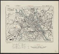
Creator:
Published / Created:
1943
Call Number:
40 V66 1943
Image Count:
1
Resource Type:
Maps, Atlases & Globes
Alternative Title:
Geographical Section, General Staff ; no. 4380, GSGS (Series) ; 4380., Italy, and Italy, town plan of Vicenza
Description:
"12/42/G.S.G.S."
Publisher:
Army Map Service, U.S. Army,
Subject (Geographic):
Vicenza (Italy)--Maps
Subject (Name):
United States. Army Map Service
Found in:
Beinecke Rare Book and Manuscript Library > Town plan of Vicenza [cartographic material].
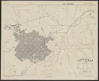
Creator:
Published / Created:
1943
Call Number:
408 V83 1943
Container / Volume:
BRBL_00239
Image Count:
1
Resource Type:
Maps, Atlases & Globes
Alternative Title:
Geographical Section, General Staff ; no. 4379, GSGS (Series) ; 4379., and Sicily 1:5,000
Description:
"6-43."
Publisher:
Army Map Service, U.S. Army,
Subject (Geographic):
Vittoria (Italy)--Maps
Subject (Name):
United States. Army Map Service
Found in:
Beinecke Rare Book and Manuscript Library > Town plan of Vittoria [cartographic material] / drawn and photolithographed by War Office, 1943.