
- None1
You Searched For
1 - 4 of 4
Search Results
2.

- Creator:
- Rowlandson, Thomas, 1756-1827, printmaker
- Published / Created:
- [not before 1814]
- Call Number:
- Auchincloss Rowlandson v. 13
- Collection Title:
- V. 4. Caricature magazine, or, Hudibrastic mirror.
- Image Count:
- 1
- Resource Type:
- still image
- Abstract:
- "A wide space leads to the harbour. On one side (left) is the corner of a large old clothes shop: 'Moses Levy Money Lent', with garments, &c., hanging from it. Opposite is the old-fashioned 'Ship Tavern'. Off shore are ships in full sail, boats are ma...
- Description:
- Title etched below image.
- Publisher:
- Thomas Tegg
- Subject (Geographic):
- Portsmouth (England)
- Subject (Topic):
- Harbor, Clothing stores, Harbors, Musical instruments, Piers & wharves, Sailors, Ships, Taverns (Inns), Telescopes, and Violins
- Found in:
- Beinecke Rare Book and Manuscript Library > Portsmouth Point [graphic]
3.
- Creator:
- Rowlandson, Thomas, 1756-1827, artist
- Published / Created:
- [1794]
- Call Number:
- Drawings R79 no. 17 Box D207
- Image Count:
- 1
- Resource Type:
- still image
- Description:
- Title from dealer's description.
- Subject (Geographic):
- Portsmouth (England)
- Subject (Name):
- Howe, Richard Howe, Earl, 1726-1799.
- Subject (Topic):
- First of June, Battle of the, 1794, Harbors, Warships, British, French, Crowds, Cannons, Carriages & coaches, Peg legs, and Victories
- Found in:
- Lewis Walpole Library > [Arrival of the flotilla of Admiral Howe into Portsmouth Harbour on 1 June 1794] [art original].
4.
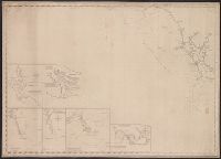
- Creator:
- E. & G.W. Blunt (Firm)
- Published / Created:
- [between 1827? and 1850?]
- Call Number:
- 21cea 1830
- Container / Volume:
- BRBL_00016
- Image Count:
- 1
- Resource Type:
- Maps, Atlases & Globes
- Description:
- Insets: Cape Fear River, from its entrance to Smithville. Scale [ca. 1:60,000] -- Beaufort harbour. Scale [ca. 1:40,000] -- The bar & roads of Occracock [sic]. Scale [ca. 1:100,000] -- Cape Hatteras. Scale [ca. 1:110,000] -- Cape Lookout. Scale [ca. 1...
- Publisher:
- E. & G.W. Blunt,
- Subject (Geographic):
- Atlantic Coast (N.C.)--Maps., Beaufort (N.C.)--Maps., Cape Fear River Estuary (N.C.)--Maps., Fear, Cape (N.C.)--Maps., Hatteras, Cape (N.C.)--Maps., Lookout, Cape (N.C.)--Maps., and North Carol
- Subject (Name):
- Hooker, William
- Subject (Topic):
- Coasts, Coasts--North Carolina--Outer Banks--Maps., Harbors, Harbors--North Carolina--Beaufort--Maps., Nautical charts, Nautical charts--No, and Nautical charts--North Carolina--Atlantic Coast.
- Found in:
- Beinecke Rare Book and Manuscript Library > [Coast chart from Cape Hatteras to Cape Fear, North Carolina [cartographic material] : with insets of Cape Hatteras, Ocracoke Bar and Roads, Cape Lookout, Beaufort Harbour, Cape Fear, and the Cape Fear River] / engraved & printed by W. Hooker.