Search
You Searched For
Search Results
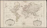
- Creator:
- Senex, John, d. 1740
- Published / Created:
- 1720]
- Call Number:
- 11 1720B
- Container / Volume:
- BRBL_00680
- Image Count:
- 1
- Resource Type:
- Maps, Atlases & Globes
- Description:
- "Most humbly inscribed to his Royal Highness George Prince of Wales"
- Publisher:
- D. Browne,
- Subject (Name):
- Senex, John, d. 1740. New general atlas
- Subject (Topic):
- World maps--Early works to 1800
- Found in:
- Beinecke Rare Book and Manuscript Library > A new map of the world [cartographic material] : from the latest observations / revised by I. Senex.
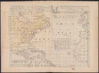
- Creator:
- Kitchin, Thomas, d. 1784
- Published / Created:
- 1760?]
- Call Number:
- 11 1755A
- Container / Volume:
- BRBL_00681
- Image Count:
- 1
- Resource Type:
- Maps, Atlases & Globes
- Alternative Title:
- London magazine.
- Description:
- Cross collection no. 43.
- Publisher:
- s.n.,
- Subject (Topic):
- World maps--Early works to 1800
- Found in:
- Beinecke Rare Book and Manuscript Library > An accurate chart of the world with the new discoveries [cartographic material] : also a view of the general and coasting trade winds, monsoons or shifting trade winds and the variations of the compass, from the latest and best authorities / by T. Kitchen
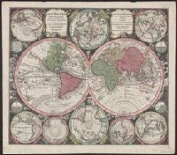
- Published / Created:
- [1733?]
- Call Number:
- 11 1733
- Container / Volume:
- BRBL_00004
- Image Count:
- 1
- Resource Type:
- Maps, Atlases & Globes
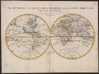
- Description:
- Double-hemispherical world map.
- Subject (Geographic):
- World--Maps--Early works to 1800
- Subject (Topic):
- World maps--Early works to 1800
- Found in:
- Beinecke Rare Book and Manuscript Library > Basis geographiæ recentioris astronomica ... a Iohanne Gabrielle Doppelmaiero ... operâ Ioh. Bapt. Homanni ...
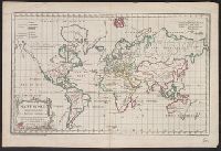
- Creator:
- Bellin, Jacques Nicolas, 1703-1772
- Published / Created:
- 1755
- Call Number:
- 11 1755
- Container / Volume:
- BRBL_00681
- Image Count:
- 1
- Resource Type:
- Maps, Atlases & Globes
- Description:
- At bottom of the title cartouche: "Par le S.r Bellin, Ingenieur de la Marine
- Publisher:
- Depot General de la Marine],
- Subject (Topic):
- World maps--Early works to 1800
- Found in:
- Beinecke Rare Book and Manuscript Library > Carte reduite des parties connues du globe terrestre dressée au Dépost des cartes, plans et journaux de la marine pour le service des vaissaux du Roy / [cartographic material] / par ordre de M. de Machault Garde de Sceaux de France, Ministre et Secretai
- Creator:
- Jefferys, Thomas, d. 1771
- Published / Created:
- 1762]
- Call Number:
- 71 1762
- Container / Volume:
- BRBL_00364
- Image Count:
- 3
- Resource Type:
- Maps, Atlases & Globes
- Description:
- "Longitude w. from London."
- Subject (Geographic):
- Atlantic Ocean--Maps--Early works to 1800 and North America--Maps--Early works to 1800
- Subject (Topic):
- World maps--Early works to 1800
- Found in:
- Beinecke Rare Book and Manuscript Library > Chart of the Atlantic Ocean, with the British, French, & Spanish settlements in North America, and the West Indies, as also on the coast of Africa / by Thos. Jefferys, geographer to His Majesty.
- Creator:
- Bünting, Heinrich, 1545-1606
Bünting, Heinrich, 1545-1606. Itinerarium Sacrae Scripturae
- Published / Created:
- 1581]
- Call Number:
- 11 1581
- Image Count:
- 2
- Resource Type:
- Maps, Atlases & Globes
- Description:
- Appears in Bünting's Itinerarium Sacrae Scripturae.
- Publisher:
- H. Bünting,
- Subject (Topic):
- World maps--Early works to 1800
- Found in:
- Beinecke Rare Book and Manuscript Library > Die gantze Welt in ein Kleberblat, welches ist der Stadt Hannover, meines lieben Vaterlandes Wapen.
- Creator:
- Seutter, Matthaeus, 1678-1756
- Published / Created:
- [1742?]
- Call Number:
- 11 1730A
- Container / Volume:
- BRBL_00681
- Image Count:
- 1
- Resource Type:
- Maps, Atlases & Globes
- Alternative Title:
- Diversi globi terr-aqvei
- Description:
- Appeared in author's Atlas novus ... [1742 or later].
- Publisher:
- Matth. Seutter,
- Subject (Name):
- Seutter, Matthaeus, 1678-1756. Atlas novus
- Subject (Topic):
- World maps--Early works to 1800
- Found in:
- Beinecke Rare Book and Manuscript Library > Diversi globi terr-aquei : statione variante et visu intercedente, per coluros tropicorum, per ambos polos et particul. sphaerae zenith in planum delineati orthographici prospectus : quibis additae, pro mutatione horizontis differentes sphaerae positiones
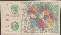
- Published / Created:
- 1673]
- Call Number:
- 56 1644
- Container / Volume:
- BRBL_00294
- Image Count:
- 1
- Resource Type:
- Maps, Atlases & Globes
- Alternative Title:
- Yudi quantu
- Description:
- "Capital edition of a complete map (of the world based on) astronomy."
- Publisher:
- s.n.,
- Subject (Geographic):
- China--Maps--Early works to 1800
- Subject (Topic):
- World maps--Early works to 1800
- Found in:
- Beinecke Rare Book and Manuscript Library > Jing ban tian wen quan tu.
- Creator:
- Rossi, Giovanni Giacomo de, 17th cent
- Published / Created:
- 1674
- Call Number:
- 11 1674
- Container / Volume:
- BRBL_00680
- Image Count:
- 1
- Resource Type:
- Maps, Atlases & Globes
- Description:
- Cross collection no. 22.
- Publisher:
- Da Gio. Iacomo de Rossi nella sua Stamperia in Roma alla Pace l'Anno,
- Subject (Name):
- Lhuilier, Jean, Rossi, Giovanni Giacomo de, 17th cent. Mercurio geografico, and Sanson, Nicolas, 1600-1667
- Subject (Topic):
- World maps--Early works to 1800
- Found in:
- Beinecke Rare Book and Manuscript Library > Mappa mondo o vero carta generale del globo terrestre [cartographic material] : rapresentato in due planisferi ... / da N. Sanson de Abbeville Giografo di sua Maesta Cristma ; intagliata da Gio. Lhuilier.
- Creator:
- Robert de Vaugondy, Gilles, 1688-1766
- Published / Created:
- 1761
- Call Number:
- 11 1761
- Container / Volume:
- BRBL_00681
- Image Count:
- 1
- Resource Type:
- Maps, Atlases & Globes
- Description:
- "Gravé par E. Dussy."
- Publisher:
- Chez l'Auteur, Quai de l'Horloge pres le Pont neuf,
- Subject (Name):
- Dussy, E., fl. 1754-1778
- Subject (Topic):
- Religions--Maps--Early works to 1800 and World maps--Early works to 1800
- Found in:
- Beinecke Rare Book and Manuscript Library > Mappe monde [cartographic material] : suivant la projection des cartes reduites / par le s. Robert de Vaugondy.