Skip to search
Skip to main content
Skip to first result
Search
You Searched For
Extent of Digitization
Completely digitized
Subject (Topic)
World maps--Early works to 1800
Search Results
Creator:
Published / Created:
[1532]
Call Number:
11 1509A
Image Count:
1
Resource Type:
Maps, Atlases & Globes
Abstract:
Decorated with sea monsters, mermaids, exotic animals, and cannibals, this wood cut map provides a marked contrast to the simplistic diagrams considered the earliest printed world maps. While the latter presented a world view based in Judeo-Christian ...
Alternative Title:
Typus cosmographicus universalis and Typvs cosmographicvs vniversalis
Description:
Appears in Johann Huttich's Novus orbis regionum. Basel. 1532.
Publisher:
[publisher not identified],
Subject (Name):
Holbein, Hans, 1497-1543 and Huttich, Johann, 1480?-1544. Novus orbis regionum.
Subject (Topic):
World maps--Early works to 1800
Found in:
Beinecke Rare Book and Manuscript Library > Typus cosmographicus uniuersalis.
Creator:
Published / Created:
1545?]
Call Number:
11 1545
Image Count:
1
Resource Type:
Maps, Atlases & Globes
Alternative Title:
Typvs vniversalis, anno 1545
Description:
Possibly from Münster's 1545 edition of Ptolemy's Geographia [Basel : Heinrich Petri, 1545].
Publisher:
Heinrich Petri,
Subject (Topic):
World maps--Early works to 1800
Found in:
Beinecke Rare Book and Manuscript Library > Typus universalis, anno 1545 [cartographic material].
Creator:
Published / Created:
1568
Call Number:
11 1568
Container / Volume:
BRBL_00732
Image Count:
1
Resource Type:
Maps, Atlases & Globes
Alternative Title:
Vniversale descrittione di tvtta la terra conoscivta fin qvi
Description:
From: [Italian composite atlases].
Publisher:
Donato Bertelli,
Subject (Name):
Forlani, Paolo and Gastaldi, Giacomo, ca. 1500-ca. 1565
Subject (Topic):
World maps--Early works to 1800
Found in:
Beinecke Rare Book and Manuscript Library > Universale descrittione di tutta la terra conosciuta fin qui / in Venetia alla libraria del segno del S. Marco in Merzaria, D.B., MDLXVIII.
Creator:
Published / Created:
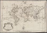
1748
Call Number:
11 1748
Container / Volume:
BRBL_00681
Image Count:
1
Resource Type:
Maps, Atlases & Globes
Description:
Cross collection no. 40.
Publisher:
s.n.],
Subject (Name):
Maurepas, Jean-Frédéric Phélypeaux, comte de, 1701-1781
Subject (Topic):
World maps--Early works to 1800
Found in:
Beinecke Rare Book and Manuscript Library > Versuch von einer Kurzgefassten Karte welche die bekannten Theile der Erdkugel / [cartographic material] / enthaelt dem Hm. grafen von Maurepas ; zugeeignet von N. Bellin.
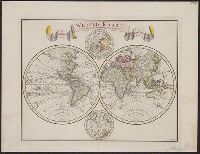
Creator:
Published / Created:
1744
Call Number:
11 1744A
Container / Volume:
BRBL_00681
Image Count:
1
Resource Type:
Maps, Atlases & Globes
Description:
"C. Sepp del. et sculps. 1744."
Publisher:
[Isaak Tirion],
Subject (Name):
Sepp, Christiaan, d. 1775
Subject (Topic):
World maps--Early works to 1800
Found in:
Beinecke Rare Book and Manuscript Library > Wereld kaart [cartographic material] : na de alderlaatste ontdekking in't licht gebragt / by Isaak Tirion.
Creator:
Published / Created:
[19--]
Call Number:
11 1538B
Image Count:
1
Resource Type:
Maps, Atlases & Globes
Description:
"Photolithographed copy of Gerard Mercator's Mapamundi of 1538 from an original engraving in the library of the American Geographical Society."
Publisher:
Julius Bien & Co., photo-lith,
Subject (Geographic):
World--Maps--Early works to 1800
Subject (Name):
American Geographical Society of New York and Julius Bien & Co
Subject (Topic):
Early maps, Early maps--Facsimiles, World maps, and World maps--Early works to 1800
Found in:
Beinecke Rare Book and Manuscript Library > [Mapamundi of 1538] [cartographic material].
Creator:
Published / Created:
1900?]
Call Number:
11 1529
Image Count:
2
Resource Type:
Maps, Atlases & Globes
Description:
Copy 2: Col. Preliminary record.
Publisher:
W. Griggs,
Subject (Topic):
World maps--Early works to 1800
Found in:
Beinecke Rare Book and Manuscript Library > [World map]
Creator:
Published / Created:
Anno Domini 1511]
Call Number:
11 1511A
Container / Volume:
BRBL_00732
Image Count:
1
Resource Type:
Maps, Atlases & Globes
Description:
Cordiform projection.
Publisher:
Per Iacobum Pentium de Leucho,
Subject (Name):
Pencio, Jacopo, active 1486-1530 and Ptolemy, active 2nd century. Geographia
Subject (Topic):
World maps--Early works to 1800
Found in:
Beinecke Rare Book and Manuscript Library > [World map].
Branch:v1.69.1 ,Deployed:2025-07-31T07:53:01-04:00