Search
You Searched For
Search Results
- Published / Created:
- 1850
- Call Number:
- 1976 Folio 96
- Collection Title:
- A new universal atlas containing maps of the various empires, kingdoms, states and republics of the
- Image Count:
- 1
- Resource Type:
- Maps, Atlases & Globes
- Publisher:
- Thomas, Cowperthwait & Co
- Subject (Geographic):
- Connecticut
- Collection Created:
- Philadelphia, Cowperthwait, DeSilver & Butler, 1854, c1850
- Found in:
- Beinecke Rare Book and Manuscript Library > 10. Map of Connecticut
- Published / Created:
- 1846
- Call Number:
- 1976 Folio 93
- Collection Title:
- A new universal atlas containing maps of the various empires, kingdoms, states and republics of the
- Image Count:
- 1
- Resource Type:
- Maps, Atlases & Globes
- Publisher:
- S. Augustus Mitchell
- Subject (Geographic):
- Connecticut
- Collection Created:
- Philadelphia, S.A. Mitchell, 1847, c1844
- Found in:
- Beinecke Rare Book and Manuscript Library > 9. Connecticut
- Published / Created:
- 1719
- Call Number:
- Defoe 50 719db 1
- Collection Title:
- The life and strange surprizing adventures of Robinson Crusoe, of York, mariner : who lived eight
- Image Count:
- 1
- Resource Type:
- Maps, Atlases & Globes
- Description:
- Map facing p. [1]
- Subject (Topic):
- Voyages and travels, Voyages around the world, and World maps --Early works to 1800
- Collection Created:
- London : Printed for W. Taylor, 1719
- Found in:
- Beinecke Rare Book and Manuscript Library > A Map of the world, on wch is delineated the voyages of Robinson Cruso
- Published / Created:
- Undated
- Call Number:
- 1973 Folio 56
- Collection Title:
- The American pilot, containing the navigation of the sea coast of North America, from the Streights
- Image Count:
- 1
- Resource Type:
- Maps, Atlases & Globes
- Subject (Geographic):
- Georgia and South Carolina
- Subject (Name):
- Norman, John, 1748?-1817 and Norman, William, d. 1807
- Subject (Topic):
- Nautical charts and Pilot guides --North America --Atlantic Coast
- Collection Created:
- Boston, Printed and sold by Wm. Norman at his office, no. 75 Newbury Street, MDCCXCIIII
- Found in:
- Beinecke Rare Book and Manuscript Library > A chart of South Carolina and Georgia
- Creator:
- Cook, James, 1728-1779
Gulielmus Whitchurch
- Published / Created:
- 1776
- Call Number:
- 1977 +300
- Collection Title:
- A voyage towards the South pole, and round the world. Performed in His Majesty’s ships the
- Image Count:
- 1
- Resource Type:
- Maps, Atlases & Globes
- Subject (Geographic):
- Antarctica --Maps --Early works to 1800 and Southern Hemisphere --Maps
- Subject (Name):
- Furneaux, Tobias, 1735-1781 and Hodges, William, 1744-1797
- Subject (Topic):
- Oceania --Discovery and exploration and Voyages around the world
- Collection Created:
- London, Printed for W. Strahan and T. Cadell, 1777
- Found in:
- Beinecke Rare Book and Manuscript Library > A chart of the southern hemisphere; shewing the tracks of some of the most distinguished navigators
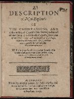
- Creator:
- Smith, John, 1580-1631
- Published / Created:
- 1616
- Call Number:
- Taylor 269
- Image Count:
- 3
- Resource Type:
- Books, Journals & Pamphlets
- Description:
- Colophon reads: At London printed the 18. of Iune, in the yeere of our Lord 1616.
- Publisher:
- Printed by Humfrey Lownes, for Robert Clerke; and are to be sould at his house called the Lodge, in Chancery lane, ouer against Lincolnes Inne,
- Subject (Geographic):
- New England -- Maps -- Early works to 1800 and New England--Description and travel--Early works to 1800
- Subject (Name):
- Smith, John, 1580-1631 --Portraits
- Found in:
- Beinecke Rare Book and Manuscript Library > A description of New-England: or The observations and discoueries, of Captain Iohn Smith, (admirall of that country) in the north of America in the year of our Lord 1614, with the successe of sixe ships that went the next yeare 1615; and the accidents befell him among the French men of warre: with the proofe of the present benefit this countrey affoords: whither this present yeare, 1616, eight voluntary ships are gone to make further tryall.
- Creator:
- Kitchin, Thomas, d. 1784.
- Published / Created:
- 1773
- Call Number:
- 1979 Folio 59
- Image Count:
- 2
- Resource Type:
- Maps, Atlases & Globes
- Publisher:
- Printed for Robert Sayer, map and printseller, at no. 53, in Fleet-Street,
- Subject (Geographic):
- Scotland --Maps --Early works to 1800
- Subject (Name):
- Sayer, Robert, 1725-1794
- Found in:
- Beinecke Rare Book and Manuscript Library > A general atlas, describing the whole universe. Being a compleat and new collection of the most approved maps extant; corrected with the utmost care, and augmented from the latest discoveries: the whole being an improvement of the maps of d'Anville and Robert ... By Thomas Kitchen, senior, and others ...
- Published / Created:
- 1797
- Call Number:
- 3213 1797
- Container / Volume:
- BRBL_00055
- Image Count:
- 1
- Resource Type:
- Maps, Atlases & Globes
- Description:
- Missing northern half of map.
- Publisher:
- J. Stockdale,
- Subject (Geographic):
- Kent (England)--Maps--Early works to 1800
- Found in:
- Beinecke Rare Book and Manuscript Library > A map of Kent.
- Creator:
- Clark, William, 1770-1838
Lewis, Samuel, 1753 or 4-1822
- Published / Created:
- [ca. 1814]
- Call Number:
- Zc10 814Le
- Collection Title:
- History of the expedition under the command of Captains Lewis and Clark, to the sources of the
- Image Count:
- 2
- Resource Type:
- Maps, Atlases & Globes
- Description:
- Verso blank.
- Subject (Geographic):
- Columbia River, Missouri River, and West (U.S.)
- Subject (Topic):
- Lewis and Clark Expedition (1804-1806)
- Collection Created:
- Philadelphia : Bradford & Inskeep ; New York : A.H. Inskeep : J. Maxwell, Printer, 1814
- Found in:
- Beinecke Rare Book and Manuscript Library > A map of Lewis and Clark's track, across the western portion of North America fom the Mississippi to the Pacific Ocean; by order of the Executive of the United States . In 1804, 5 & 6
- Creator:
- Dawes, William, 1762-1836
- Published / Created:
- 1791 March
- Call Number:
- DU170 H85+ Oversize
- Collection Title:
- An historical journal of the transactions at Port Jackson and Norfolk island, with the discoveries
- Image Count:
- 1
- Resource Type:
- Books, Journals & Pamphlets
- Subject (Geographic):
- New South Wales --History
- Subject (Name):
- Ball, Henry Lidgbird, King, Philip Gidley, 1758-1808, and Phillip, Arthur, 1738-1814
- Collection Created:
- London : J. Stockdale, 1793
- Found in:
- Beinecke Rare Book and Manuscript Library > A map of all those parts of the territory of New South Wales which have been seen by any person belonging to the settlement established at Port Jackson, in the said territory ...


