Skip to search
Skip to main content
Skip to first result
Search
You Searched For
Extent of Digitization
Partially digitized
Genre
Maps in books
Language
German
Search Results
Creator:
Published / Created:
Undated
Call Number:
1973 Folio 71
Collection Title:
[Atlas nouveau contenant toutes les parties du monde ou sont exactement marques les empires
Image Count:
1
Resource Type:
Maps, Atlases & Globes
Abstract:
Factitious collection of about 549 maps taken from the atlases of the 17th and the beginning of the 18th century, put together with the title "Atlas" and bound in 6 volumes. These volumes originally bore the imprint: Amstelaedamii apvd Reiniervm & Jos...
Description:
Verso blank.
Subject (Geographic):
British Isles --Maps --Early works to 1800
Subject (Name):
Leth, Hendrik de, 1703-1766, Reiner et Josua Ottens (Firm), Schenck, Peter, 1661-1715, Schenck, Peter, ca. 1698-1752, Valck, G. (Gerard), 1651 or 2-1726, and Wit, Frederik de
Subject (Topic):
Atlases --Early works to 1800
Collection Created:
[A Amsterdam, chez J. Covens & C. Mortier, ca. 1730-ca. 1800]
Found in:
Beinecke Rare Book and Manuscript Library > A new mapp of the kingdome of England, representing the princedome of Wales, and other provinces, cities, market towns, with the roads from town to town and the number of reputed miles between them, are given by inspection without scale or compass
Published / Created:
1720
Call Number:
Zc20 720hic
Image Count:
2
Description:
Originally pub. Leipzig, 1720, with title: Historische und geographische Beschreibung ... Cf. Sabin no. 32104.
Publisher:
J.F. Gleditschens seel. sohn,
Subject (Geographic):
Louisiana--History--To 1803 and Mississippi River Valley--Description and travel
Subject (Name):
Compagnie des Indes
Found in:
Beinecke Rare Book and Manuscript Library > Ausführliche historische und geographische beschreibung des an dem grossen flusse Mississipi in Nord-America gelegenen herrlichen landes Louisiana; in welches die neu-aufgerichtete frantzösische grosse indianische compagnie colonien zu schicken angefangen; worbey zugleich einige reflexionen über die weit-hinaus sehende desseins gedachter compagnie, und des darüber entstandenen actien-handels, eröffnet werden.
Published / Created:
Undated
Call Number:
1983 Folio 19
Collection Title:
[Atlas factice of 96 maps by Blaeu, Visscher, Jansson, Hondius and others]
Image Count:
2
Publisher:
Apud Ioannem Ianssonium
Subject (Geographic):
Austria --Maps --Early works to 1800, Czechoslovakia --Maps, Germany --Maps --Early works to 1800, and Poland --Maps --Early works to 1800
Subject (Topic):
Atlases --Early works to 1800
Collection Created:
[1556-1680]
Found in:
Beinecke Rare Book and Manuscript Library > Bohemia
Published / Created:
Undated
Call Number:
Taylor 229
Collection Title:
Neuwe Schiffart / warhafftige vnd eygentliche Beschreibung der langwirigen / soerglichen vnd
Image Count:
1
Description:
Bound in after p. 92.
Subject (Geographic):
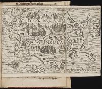
Borneo --Maps --Early works to 1800
Collection Created:
Gedruckt zu Franckfurt / Durch Matthaeum Becker, 1602
Found in:
Beinecke Rare Book and Manuscript Library > Borneo Insula
Creator:
Published / Created:
1738
Call Number:
Bw23 26
Image Count:
3
Description:
"Beylage des Projects, welches die Sorbonne Anno 1717. dem Czaren wegen Vereinigung der Römisch-Catholischen und Russisch-Griechischen Religion übergeben, und wovon im vorhergehenden Tractat gedacht worden": p. 433-444 (vol. 1).
Publisher:
Bey Nicolai Försters und Sohnes ... ,
Subject (Geographic):
Russia--Description and travel and Saint Petersburg (Russia) -- Maps -- Early works to 1800
Found in:
Beinecke Rare Book and Manuscript Library > Das veränderte Russland, in welchem die jetzige Verfassung des Geist- und Weltlichen Regiments : der Kriegs-Staat zu Lande und zu Wasser, der wahre Zustand der russischen Finantzen ... die Begebenheiten des Czarewitzen, und was sich sonst Merckwürdiges in Russland zugetragen, nebst verschiedenen bisher unbekannten Nachrichten vorgestellt werden, mit einer accuraten Land-Charte und Kupferstichen versehen.
Published / Created:
Undated
Call Number:
Taylor 229
Collection Title:
Neuwe Schiffart / warhafftige vnd eygentliche Beschreibung der langwirigen / soerglichen vnd
Image Count:
1
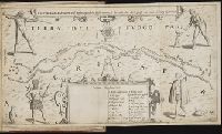
Abstract:
Map of the Strait of Magellan also depicts native people and animals.
Description:
Bound in after p. 4.
Subject (Geographic):
Magellan, Strait of (Chile and Argentina) --Maps --Early works to 1800
Collection Created:
Gedruckt zu Franckfurt / Durch Matthaeum Becker, 1602
Found in:
Beinecke Rare Book and Manuscript Library > Fretum Magellannicum ...
Creator:
Published / Created:
[ca. 1556?]
Call Number:
1983 Folio 19
Collection Title:
[Atlas factice of 96 maps by Blaeu, Visscher, Jansson, Hondius and others]
Image Count:
2
Description:
A set of 9 maps (no. IIII-XII) are from the Stumpf-Chronik.
Publisher:
[Christoffel Froschauer]
Subject (Geographic):
Germany, Southern --Maps --Early works to 1800 and Switzerland --Maps --Early works to 1800
Subject (Topic):
Atlases --Early works to 1800
Collection Created:
[1556-1680]
Found in:
Beinecke Rare Book and Manuscript Library > IIII. Die gantz Eydgenoschafft
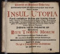
Creator:
Published / Created:
1704
Call Number:
1974 3368
Image Count:
5
Resource Type:
Books, Journals & Pamphlets
Alternative Title:
[Utopia. German]
Publisher:
Verlegt in Henning Grossens Buchhandlung
Subject (Name):
Cantiuncula, Claudius, d. 1560?, Erasmus, Desiderius, d. 1536, and Hall, Joseph, 1574-1656. Mundus alter et idem
Found in:
Beinecke Rare Book and Manuscript Library > Ordentliche und aussfuehrliche Beschreibung der ... Insul Utopia ... : Beschriieben durch den hochgelahrten und welt-beruehmten Herrn Thomam Morum ... : Mit vielen schoenen Kupfferstuecken und Land-Beschreibungen
Branch:v1.69.6 ,Deployed:2025-08-20T10:40:23-04:00