Skip to search
Skip to main content
Skip to first result
Search
You Searched For
Extent of Digitization
Partially digitized
Subject (Topic)
Atlases--Early works to 1800
Search Results
Published / Created:
[1729?]
Call Number:
1973 +32
Collection Title:
La galerie agreable du monde, où l'on voit en un grand nombre de cartes tres-exactes et de belles
Image Count:
1
Resource Type:
Maps, Atlases & Globes
Alternative Title:
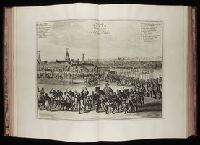
Benin, ville de la Guinee, en Afrique
Description:
Tab mounted.
Subject (Geographic):
Africa--Pictorial works--Early works to 1800 and Benin (Kingdom) --Pictorial works--Early works to 1800
Subject (Name):
Elmina Castle (Elmina, Ghana)
Subject (Topic):
Atlases--Early works to 1800 and Geography--Pictorial works
Collection Created:
Le tout mis en ordre & executé à Leide, par Pierre vander Aa [1729?]
Found in:
Beinecke Rare Book and Manuscript Library > De Stadt Benin
Creator:
Published / Created:
1635
Call Number:
1988 Folio 13
Collection Title:
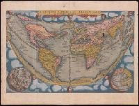
Theatrum orbis terrarum. French
Image Count:
3
Alternative Title:
Nova Belgica et Anglia Nova
Description:
Maps hand-colored.
Publisher:
Apud Guiljelmum et Iohannem Blaeu,
Subject (Geographic):
Middle Atlantic States -- Maps -- Early works to 1800 and New England -- Maps -- Early works to 1800
Subject (Topic):
Atlases, Dutch and Atlases--Early works to 1800
Found in:
Beinecke Rare Book and Manuscript Library > La Nouvelle Belgique & la Nouvelle Angleterre
Creator:
Published / Created:
1635
Call Number:
1988 Folio 13
Collection Title:
Theatrum orbis terrarum. French
Image Count:
3
Description:
Maps hand-colored.
Publisher:
Apud Guiljelmum et Iohannem Blaeu,
Subject (Geographic):
Virginia -- Maps -- Early works to 1800 and Virginia--Description and travel -- Early works to 1800
Subject (Topic):
Atlases, Dutch and Atlases--Early works to 1800
Found in:
Beinecke Rare Book and Manuscript Library > La Verginie
Creator:
Published / Created:
1713
Call Number:
1978 Folio 112
Image Count:
1
Resource Type:
Maps, Atlases & Globes
Alternative Title:
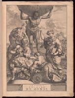
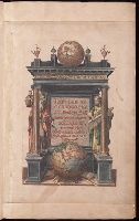
Geographie royale
Description:
Title in red and black with vignette.
Publisher:
Chez Pierre vander Aa, marchand libraire,
Subject (Topic):
Atlases, French, Atlases--Early works to 1800, and Geography--Early works to 1800
Found in:
Beinecke Rare Book and Manuscript Library > Le nouveau theatre du monde. ou La geographie royale, composée de nouvelles cartes tres-exactes ... Avec une description geographique et historique des quatre parties de l'univers, desquelles l'Europe en detail est écrite par Mr. Gueudeville, & les trois autres parties par Mr. Ferrarius ...
Creator:
Published / Created:
1635
Call Number:
1988 Folio 13
Collection Title:
Theatrum orbis terrarum. French
Image Count:
3
Alternative Title:
Nouvel atlas. and Theatre du monde
Description:
Beinecke copy imperfect: map of "Valesium Ducatus" (signature RRR of v. 1) wanting; tp. and several leaves of v. 1 repaired with slight damage to text; map of "India" in v. 2 mutilated.
Publisher:
Apud Guiljelmum et Iohannem Blaeu,
Subject (Geographic):
Oléron, Ile d' (France) --Maps --Early works to 1800 and Ré Island (France) --Maps --Early works to 1800
Subject (Topic):
Atlases, Dutch and Atlases--Early works to 1800
Found in:
Beinecke Rare Book and Manuscript Library > Les isles de Reí & D'Oleíron
Call Number:
1973 +32
Collection Title:
La galerie agreable du monde, où l'on voit en un grand nombre de cartes tres-exactes et de belles
Image Count:
1
Resource Type:
Maps, Atlases & Globes
Alternative Title:
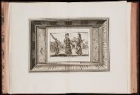
Ministres d'etat au cour du Grand Mogol.
Subject (Topic):
Atlases--Early works to 1800 and Geography--Pictorial works
Collection Created:
Le tout mis en ordre & executé à Leide, par Pierre vander Aa [1729?]
Found in:
Beinecke Rare Book and Manuscript Library > Mine de Diamans, aux Indes Orientales
Creator:
Published / Created:
[1578]
Call Number:
1976 Folio 2
Image Count:
1
Alternative Title:
Speculum geographicum totivs Germaniae repraesentans. and Speculum orbis terrarum
Description:
Foliation: 2 unnumbered bifolia, XXVII bifolia, 1 bifolium, XXXVIII bifolia, 1 unnumbered bifolium.
Publisher:
de Catelyne Vesten, ad intersigne Floreni aurati, in aedibus Gerardi de Iode, typis Gerardi Smits,
Subject (Topic):
Atlases--Early works to 1800
Found in:
Beinecke Rare Book and Manuscript Library > Specvlvum orbis terrarvm.
Creator:
Published / Created:
1578]
Call Number:
1977 Folio 130
Image Count:
1
Alternative Title:
Tabulae geographicae
Description:
Signatures: [*]¹ (?)² (?)(?)¹ **² A-G² N² [+]¹ I-M² H² O-Z² Aa-Cc² a-g² h¹. Hand colored illustrations.
Publisher:
typis Godefridi Kempensis, Anno Virgineit partvs,
Subject (Name):
Paulett, A.M.--Autograph (BEIN 1976 Folio 137)
Subject (Topic):
Atlases--Early works to 1800 and Early maps
Found in:
Beinecke Rare Book and Manuscript Library > Tabvlae geographicae Cl: Ptolemei ad mentem autoris restitutae & emendate per Gerardum Mercatorem ...