The present state of New-England ; being a narrative of the troubles with the Indians in New
Image Count:
2
Description:
Imperfect: map wanting and supplied in facsimile; only a remnant of original map remains. This copy has what is considered the correct map for this edition, the mound immediately beneath the title being designated as "The Wine Hills", the Boston edition h
Subject (Geographic):
New England --History --Colonial period, ca. 1600-1775
Subject (Topic):
Indians of North America --New England, King Philips War, 1675-1676., and Pequot War, 1636-1638.
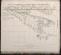
Pichardo’s treatise on the limits of Louisiana and Texas : an argumentative historical treatise
Image Count:
1
Alternative Title:
Section of the Langara map of the coasts of the Mexican Gulf, 1799-1805.
Description:
Bound in between p. 350-51.
Subject (Geographic):
Florida--Maps--Early works to 1800, Louisiana--Maps--Early works to 1800, Mexico, Gulf of--Maps--Early works to 1800, and Mexico--Maps--Early works to 1800
Collection Created:
Austin, Tex. : The University of Texas Press, 1931-1946
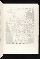
Maps of the Orinoco-Essequibo region, South America. Compiled for the Commission appointed by the
Image Count:
1
Resource Type:
Maps, Atlases & Globes
Subject (Geographic):
Amazon River--Discovery and exploration--Spanish, Amazon River--Maps, Caribbean Area--Maps--Early works to 1800, Colombia --Maps, Guyana --Maps, Orinoco River Valley (Venezuela and Colombia) --Maps, and Venezuela --Maps