Search
You Searched For
Search Results
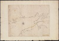
- Published / Created:
- 1714
- Call Number:
- 732 F963 1714
- Container / Volume:
- BRBL_00708
- Image Count:
- 1
- Resource Type:
- Maps, Atlases & Globes
- Description:
- Color: pen and ink drawing with some yellow.
- Subject (Geographic):
- Nova Scotia--Maps, Manuscript--Early works to 1800
- Found in:
- Beinecke Rare Book and Manuscript Library > A Draft of the Bay of Fundy by John Wells.
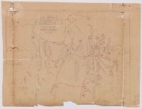
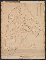
- Published / Created:
- [1840?].
- Call Number:
- 764 B77 1740
- Container / Volume:
- BRBL_00710
- Image Count:
- 1
- Resource Type:
- Maps, Atlases & Globes
- Description:
- Perhaps traced from another map.
- Subject (Geographic):
- Brimfield (Mass. : Town)--Maps, Manuscript--Early works to 1800
- Found in:
- Beinecke Rare Book and Manuscript Library > A Map of Brimfield as it was from its settlement 1720 till 1740. [Rev.] J[ason] Morse.
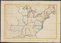
- Published / Created:
- 1774
- Call Number:
- 771 1774
- Container / Volume:
- BRBL_00713
- Image Count:
- 1
- Resource Type:
- Maps, Atlases & Globes
- Description:
- Color: water color.
- Subject (Geographic):
- New York--Maps--Early works to 1800
- Found in:
- Beinecke Rare Book and Manuscript Library > A Map of the Province of New York as divided into Counties together with the adjacent provinces. Compiled from the latest Maps and Actual Surveys. Will:Cockburn.
- Published / Created:
- 1828
- Call Number:
- 75 1828D
- Container / Volume:
- BRBL_00709
- Image Count:
- 1
- Resource Type:
- Maps, Atlases & Globes
- Description:
- Color: pen and ink drawing; blue, green, purple, yellow and orange.
- Subject (Geographic):
- United States--Maps, Manuscript
- Found in:
- Beinecke Rare Book and Manuscript Library > A Map of the United States. Projected by Nancy Gibbs, Livermore, 1828.
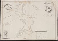
- Published / Created:
- [175-?]
- Call Number:
- 732 1750
- Container / Volume:
- BRBL_00708
- Image Count:
- 1
- Resource Type:
- Maps, Atlases & Globes
- Alternative Title:
- Map of the surveyed parts of Nova Scotia and Plan of Fort Cumberland at BeauSejour.
- Description:
- Includes "A plan of Fort Cumberland at BeauSejour" (scale [ca. 1:985]) and ill.
- Subject (Geographic):
- Fort Cumberland (N.B.)--Maps, Manuscript and Nova Scotia--Maps, Manuscript
- Found in:
- Beinecke Rare Book and Manuscript Library > A Map of the surueyed parts of Noua Scotia.
- Published / Created:
- 1798
- Call Number:
- 27cea 1798
- Container / Volume:
- BRBL_00700
- Image Count:
- 1
- Resource Type:
- Maps, Atlases & Globes
- Description:
- Original manuscript map.
- Publisher:
- Laurie & Whittle,
- Subject (Geographic):
- Indonesia--Maps, Manuscript--Early works to 1800
- Found in:
- Beinecke Rare Book and Manuscript Library > A New Chart of the Eastern Straits or the Straits of the East of Java, with a part of the Banda Sea; corrected and improved chiefly from the observation of Captn. - Williams.
- Published / Created:
- [ca. 1789]
- Call Number:
- 6555cea 1789
- Container / Volume:
- BRBL_00708
- Image Count:
- 3
- Resource Type:
- Maps, Atlases & Globes
- Description:
- A plan of the Cove at Bassa with the adjacent roads.
- Publisher:
- Robert Sayer,
- Subject (Geographic):
- Ghana--Maps, Manuscript--Early works to 1800
- Found in:
- Beinecke Rare Book and Manuscript Library > A New Survey of that part of the Coast of Africa comprised between Cape Verga and Cape Formoso, including chiefly the Windward and Gold Coasts in which the Latitudes of all the Principal Places are determined by Actual observations, the bearings and cours
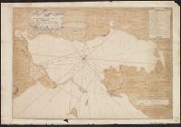
- Published / Created:
- 1711
- Call Number:
- 764 B65 1711
- Container / Volume:
- BRBL_00710
- Image Count:
- 1
- Resource Type:
- Maps, Atlases & Globes
- Description:
- Color: ink and yellow.
- Subject (Geographic):
- Boston (Mass.)--Maps--Early works to 1800
- Found in:
- Beinecke Rare Book and Manuscript Library > A New plan of the Harbour of Boston in New England. Lat. 42, 29 North. Long. 71 West. Surveyed by Order of the Commissioners of her Majesty's Navy.
- Published / Created:
- 1821
- Call Number:
- 764 W688 1821
- Container / Volume:
- BRBL_00710
- Image Count:
- 1
- Resource Type:
- Maps, Atlases & Globes
- Description:
- Color: pen and ink, some detail in green, yellow and blue.
- Subject (Geographic):
- Wilmington (Mass. : Town)--Maps, Manuscript
- Found in:
- Beinecke Rare Book and Manuscript Library > A Plan of Wilmington Taken October 1821 by Edmund Parker.
- Published / Created:
- 1745
- Call Number:
- 7325cea L93 1745
- Container / Volume:
- BRBL_00709
- Image Count:
- 1
- Resource Type:
- Maps, Atlases & Globes
- Description:
- Color: Pen and ink drawing.
- Subject (Geographic):
- Louisbourg (N.S.)--Maps, Manuscript--Early works to 1800
- Found in:
- Beinecke Rare Book and Manuscript Library > A Plan of the Harbour and Fortifications of Louisburg. The Harbour Survey'd by Capt. Phil: Durell. The fortifications by Capt. Will: Henry Bastide. Anne. 1745.