Skip to search
Skip to main content
Skip to first result
Search
You Searched For
Format
cartographic
Genre
Maps
Language
Polish
New Search
Search Results
Published / Created:
Undated
Call Number:
1983 Folio 19
Collection Title:
[Atlas factice of 96 maps by Blaeu, Visscher, Jansson, Hondius and others]
Image Count:
2
Publisher:
Apud Ioannem Ianssonium
Subject (Geographic):
Austria --Maps --Early works to 1800, Czechoslovakia --Maps, Germany --Maps --Early works to 1800, and Poland --Maps --Early works to 1800
Subject (Topic):
Atlases --Early works to 1800
Collection Created:
[1556-1680]
Found in:
Beinecke Rare Book and Manuscript Library > Bohemia
Creator:
Published / Created:
1775
Call Number:
1983 Folio 23
Collection Title:
[Atlas factice of 50 maps, primarily by Johann Baptist Homann and/or issued by the Homann Erben
Image Count:
1
Publisher:
Impensis Homannianorum Haeredum
Subject (Geographic):
Bohemia (Czech Republic) --Maps --Early works to 1800, Galicia (Poland and Ukraine) --Maps --Early works to 1800, and Ukraine --Maps --Early works to 1800
Collection Created:
[Nuremberg : Homann Erben, 1710-1786]
Found in:
Beinecke Rare Book and Manuscript Library > Lubomeriae et Galliciae regni tabula geographica / [cartographic material] / F.I.G
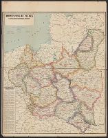
Published / Created:
[1919?].
Call Number:
11hcf 1919B-1
Image Count:
1
Resource Type:
Maps, Atlases & Globes
Description:
Legend indicates ethnic groups and political frontiers.
Publisher:
Wydawnictwo Biura Pracy Spolecznej,
Subject (Geographic):
Europe, Central--Maps
Subject (Topic):
Ethnology
Found in:
Beinecke Rare Book and Manuscript Library > Ludność Ziem Polskich / Lit. W. Główczewski.
Creator:
Published / Created:
1931
Call Number:
356cb L98 1931
Container / Volume:
BRBL_00115
Image Count:
1
Resource Type:
Maps, Atlases & Globes
Description:
Relief shown by contours and spot heights.
Publisher:
Ksi*a*znica-Atlas S.A.,
Subject (Geographic):
Lʹviv Region (Ukraine)--Maps
Found in:
Beinecke Rare Book and Manuscript Library > Mapa okolic Lwowa = [Map of the environs of Lwow] / Instytut kartograficzny Prof. E. Romera.
Published / Created:
1936
Call Number:
30gmm 1936
Container / Volume:
BRBL_00038
Image Count:
1
Resource Type:
Maps, Atlases & Globes
Description:
List of radio stations on border of map.
Publisher:
Wojskowego Inst. Geograficznego
Subject (Geographic):
Europe--Maps
Found in:
Beinecke Rare Book and Manuscript Library > Mapa radjokomunikacyjna Europy
Creator:
Published / Created:
c1923.
Call Number:
356 1923
Container / Volume:
BRBL_00114
Image Count:
1
Resource Type:
Maps, Atlases & Globes
Description:
"Made in USA.", Sep. into two sheets., and Text: "Podział Administracyjny Rzeczypospolitej Polskiej na Województwa i Powiaty."
Publisher:
Geographical Pub. Co.,
Subject (Geographic):
Poland--Administrative and political divisions--Maps
Found in:
Beinecke Rare Book and Manuscript Library > Rzeczpospolita Polska : w granicach obecnych z Podziałem na Województwa i z Wyszczególnieniem Wszystkich miast Powiatowych.
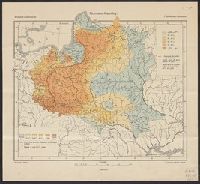
Published / Created:
[1919?]
Call Number:
11hcf 1919B-23
Container / Volume:
BRBL_00010Q
Image Count:
1
Resource Type:
Maps, Atlases & Globes
Description:
Indicates the percentages of Roman Catholics and Jews in the area covered by modern-day Poland, Belarus, and the Ukraine.
Publisher:
G. Freytag & Berndt,
Subject (Geographic):
Europe, Eastern--Maps
Subject (Topic):
Ethnology--Europe, Eastern--Maps and Religions--Europe, Eastern--Maps
Found in:
Beinecke Rare Book and Manuscript Library > Rzymsko-Katolicy = Römisch-Katholische = Catholiques Romains / Opracował E. Romer.
Creator:
Published / Created:
1993
Call Number:
356 W249 1993
Container / Volume:
BRBL_00114
Image Count:
2
Resource Type:
Maps, Atlases & Globes
Alternative Title:
Warszawa, city map, Warszawa, Plan de la ville, Warszawa, plan goroda, and Warszawa, Stadtplan
Description:
No. on panel: 33-192-03.
Subject (Geographic):
Warsaw (Poland)--Maps
Found in:
Beinecke Rare Book and Manuscript Library > Warszawa, plan miasta = Warszawa, city map = Warszawa, Stadtplan = Warszawa, Plan de la ville = Warszawa, plan goroda.
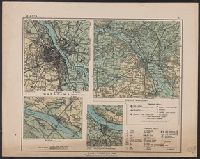
Published / Created:
1920?]
Call Number:
356cbf 1920
Container / Volume:
BRBL_00115
Image Count:
1
Resource Type:
Maps, Atlases & Globes
Description:
In upper right corner of margin: III. and Warszawa -- Płock -- Włocławek -- Okolice Warszawy.
Publisher:
Institut Kartograficzny?
Subject (Geographic):
Płock (Poland)--Maps, Warsaw (Poland)--Maps, and Włocławek (Poland)--Maps
Found in:
Beinecke Rare Book and Manuscript Library > Warszawa.
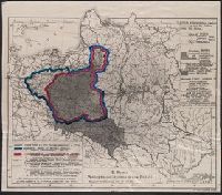
Creator:
Published / Created:
1916
Call Number:
356fd 1918
Container / Volume:
BRBL_00114
Image Count:
1
Resource Type:
Maps, Atlases & Globes
Description:
"Premium bezpłatne "Głosu Narodu" na r. 1917"--Cover., Imperfect: 7 p. wanting. Enlarged photocopy with English translations of map text., and Title from cover.
Publisher:
Książnica Polska : and Tow. Nauczycieli Szkół Wyższych,
Subject (Geographic):
Poland--Boundaries--Maps and Poland--Maps
Found in:
Beinecke Rare Book and Manuscript Library > Wojenno-polityczna mapa Polski / E. Romer.
Branch:v1.65.8 ,Deployed:2025-04-02T07:24:48-04:00