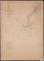
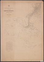
1.

- Creator:
- Maury, Matthew Fontaine, 1806-1873
- Published / Created:
- 1853
- Call Number:
- 11cfk 1850C-3
- Container / Volume:
- BRBL_00770
- Image Count:
- 2
- Resource Type:
- Maps, Atlases & Globes
- Alternative Title:
- [Maury map collection ; ser. C6] and South Atlantic
- Description:
- Copy imperfect: Mounted on cloth.
- Publisher:
- National Observatory,
- Subject (Name):
- Maury, Matthew Fontaine, 1806-1873. Wind and current charts, United States Naval Observatory, United States. Bureau of Ordnance and Hydrography, United States. Hydrographic Office, and Warrington, L. (Lewis), 1782-1851
- Subject (Topic):
- Nautical charts--South Atlantic Ocean and Winds--South Atlantic Ocean--Charts, diagrams, etc
- Found in:
- Beinecke Rare Book and Manuscript Library > Pilot chart of the South Atlantic [cartographic material] / by M.F. Maury, L.L.D. Lieut. U.S. Navy ; compiled at the National Observatory from materials in the Bureau of Ordnance and Hydrography, Commodore Lewis Warrington, Chief of Bureau.