1.

- Creator:
- Maury, Matthew Fontaine, 1806-1873
- Published / Created:
- 1852-1853.
- Call Number:
- 11cfk 1850C-5
- Container / Volume:
- BRBL_00771
- Image Count:
- 5
- Resource Type:
- Maps, Atlases & Globes
- Alternative Title:
- [Maury map collection ; ser. C8] and North Pacific
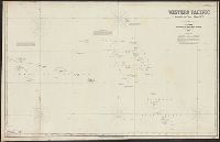
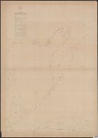
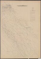
- Description:
- Sheet 1 is mistitled; it covers the northwestern Indian Ocean near Somalia and the Arabian Peninsula. This area is also covered on part of the Pilot chart of the North Indian Ocean. and Sheet 1. 1853 -- sheet 2. 1853 -- sheet 3. 1853 -- sheet 5. 1852 -- sheet
- Publisher:
- United States Naval Observatory,
- Subject (Geographic):
- North Pacific Ocean--Charts, diagrams, etc
- Subject (Name):
- Maury, Matthew Fontaine, 1806-1873. Wind and current charts, Morris, Charles, 1784-1856, United States Naval Observatory, United States. Bureau of Ordnance and Hydrography, and United States. Hydrographic Office
- Subject (Topic):
- Nautical charts--North Pacific Ocean and Winds--North Pacific Ocean--Charts, diagrams, etc
- Found in:
- Beinecke Rare Book and Manuscript Library > Pilot chart of the North Pacific [cartographic material] / by M.F. Maury, L.L.D. Lieut. U.S. Navy, superin'dt. of U.S.N. Observatory ; compiled from materials in the Bureau of Ordnance and Hydrography, Commodore Charles Morris, Chief of Bureau.