Skip to search
Skip to main content
Skip to first result
Search
You Searched For
Format
cartographic
Subject (Name)
A. Hoen & Co
Search Results
Published / Created:
1852?]
Call Number:
846 1852
Container / Volume:
BRBL_00620
Image Count:
2
Resource Type:
Maps, Atlases & Globes
Description:
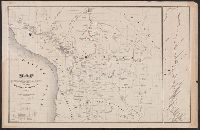
"Surveyor General's Office, Oregon City, October 21st, 1852, Jn. B. Preston [signature], Surveyor General." and Relief shown by hachures.
Publisher:
Surveyor General?,
Subject (Geographic):
Oregon--Maps
Subject (Name):
A. Hoen & Co
Found in:
Beinecke Rare Book and Manuscript Library > A diagram of a portion of Oregon Territory.
Creator:
Published / Created:
1899
Call Number:
784ca 1899
Container / Volume:
BRBL_00512
Image Count:
1
Resource Type:
Maps, Atlases & Globes
Description:
Also covers part of Pennsylvania, Maryland, Kentucky, and Ohio., Below lower margin at left: A. Hoen & Co. Lith., Include text at upper left & right corners within map border., Includes chart of explanations., Relief shown by hachures., and Shows state and county
Publisher:
West Virginia Geological and Economic Survey?],
Subject (Geographic):
West Virginia--Maps
Subject (Name):
A. Hoen & Co, West Virginia Geological and Economic Survey, and White, I. C. (Israel Charles), 1848-1927
Subject (Topic):
Geology--West Virginia--Maps and Mines and mineral resources--West Virginia
Found in:
Beinecke Rare Book and Manuscript Library > A map of West Virginia / compiled by Russell L. Morris, C.E., from county atlases, government and other surveys, showing the coal, oil, and gas developments, prominent anticlinal axes, and the outcrops of the different coal series by I. C. White.
Creator:
Published / Created:
1855]
Call Number:
818 1855B
Container / Volume:
BRBL_00565
Image Count:
1
Resource Type:
Maps, Atlases & Globes
Alternative Title:
Senate executive document (United States. Congress. Senate) ; 34th Congress, 1st session, no. 1.
Description:
"A, (1 & 2)", "Sen. Ex. Doc. No. 1, 34th. Cong.: 1st Sess.", and Relief shown by hachures.
Publisher:
s.n.,
Subject (Geographic):
Arkansas--Surveys--Maps
Subject (Name):
A. Hoen & Co
Found in:
Beinecke Rare Book and Manuscript Library > Arkansas / Surveyor's Office Little Rock Oct. 18th 1855. Henry M. Rector, Sur. Genl. of Arks.
Published / Created:
1896
Call Number:
777cbf B21 1894
Container / Volume:
BRBL_00504
Image Count:
36
Resource Type:
Maps, Atlases & Globes
Description:
"Contour interval 5 ft. Datum, mean low water at Baltimore." and Relief shown by contours, isolines, and pictorially.
Publisher:
Photo-Lith. by A. Hoen,
Subject (Geographic):
Baltimore (Md.)--Maps
Subject (Name):
A. Hoen & Co and Douglas, H. T
Found in:
Beinecke Rare Book and Manuscript Library > City of Baltimore topographical survey / made under the direction of H.T. Douglas, chief engineer.
Published / Created:
1894
Call Number:
777 B21 1894A
Container / Volume:
BRBL_00503
Image Count:
1
Resource Type:
Maps, Atlases & Globes
Description:
"Contour interval 5 ft. Datum, mean low water at Baltimore."., "Drawn by Thos. M. Ward, Jan'y. 1895"., and Relief shown by contours, isolines, and pictorially.
Publisher:
Photo-Lith. by A. Hoen,
Subject (Geographic):
Baltimore (Md.)--Maps
Subject (Name):
A. Hoen & Co and Douglas, H. T
Found in:
Beinecke Rare Book and Manuscript Library > City of Baltimore topographical survey : Sheet 1N. - 4W. / made under the direction of H.T. Douglas, chief engineer.
Published / Created:
1894
Call Number:
777 B21 1894A
Container / Volume:
BRBL_00503
Image Count:
1
Resource Type:
Maps, Atlases & Globes
Description:
"Contour interval 5 ft. Datum, mean low water at Baltimore."., "Drawn by M.A. Cudlipp, Oct.1894"., and Relief shown by contours, isolines, and pictorially.
Publisher:
Photo-Lith. by A. Hoen,
Subject (Geographic):
Baltimore (Md.)--Maps
Subject (Name):
A. Hoen & Co and Douglas, H. T
Found in:
Beinecke Rare Book and Manuscript Library > City of Baltimore topographical survey : Sheet 2N. - 2W. / made under the direction of H.T. Douglas, chief engineer.
Creator:
Published / Created:
1905?]
Call Number:
837gce T764 1905
Container / Volume:
BRBL_00594
Image Count:
1
Resource Type:
Maps, Atlases & Globes
Description:
"Third annual report Reclamation Service, Pl. XXXI.", Relief shown by hachures and spot heights., and Shows irrigable lands, surveyed canal lines, and irrigation canals under construction.
Publisher:
U.S. G.P.O,
Subject (Name):
A. Hoen & Co and Geological Survey (U.S.). Reclamation Service. Annual report of the Reclamation Service
Subject (Topic):
Irrigation projects--Carson River Watershed (Nev.)--Maps, Irrigation projects--Truckee River Watershed (Calif. and Nev.)--Maps, and Irrigation--Nevada--Maps
Found in:
Beinecke Rare Book and Manuscript Library > General map of Truckee-Carson Project, Nevada / U.S. Geological Survey.
Published / Created:
1889
Call Number:
827 1889
Container / Volume:
BRBL_00577
Image Count:
1
Resource Type:
Maps, Atlases & Globes
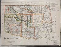
Description:
Relief shown by hachures. and Shows the lands occupied by various tribes and includes details about land transfers and cessions.
Publisher:
s.n.],
Subject (Geographic):
Oklahoma--Administrative and political divisions--Maps
Subject (Name):
A. Hoen & Co, Maxwell, Charles A, Olberg, John, and United States. Office of Indian Affairs
Subject (Topic):
Indians of North America--Oklahoma--Maps
Found in:
Beinecke Rare Book and Manuscript Library > Indian territory / compiled under the direction of the Hon. John H. Oberly, Commissioner of Indian Affairs, by C.A. Maxwell ; John Olberg, draftsman.
Creator:
Published / Created:
[1854]
Call Number:
98 1854
Container / Volume:
BRBL_00679
Image Count:
1
Resource Type:
Maps, Atlases & Globes
Description:
Includes inset map of Madeira River. and Senate executive document (United States. Congress. Senate). 32nd Congress, 2nd session, no. 36.
Publisher:
A. Hoen,
Subject (Geographic):
Bolivia--Maps
Subject (Name):
A. Hoen & Co
Found in:
Beinecke Rare Book and Manuscript Library > Map drawn by Lieut. Lardner Gibbon to accompany his Report, 1854.
Creator:
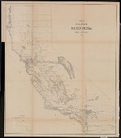
Published / Created:
1855]
Call Number:
844 1855
Container / Volume:
BRBL_00601
Image Count:
1
Resource Type:
Maps, Atlases & Globes
Alternative Title:
Senate executive document (United States. Congress. Senate) ; 34th Congress, 1st session, no. 1.
Description:
"Sen. Ex. Doc. No. 1, 34th Cong., 1st Sess.", From: Report of the Commissioner of the General Land Office, 1856., Relief shown by hachures., and Shows drainage, township lines, etc.
Publisher:
s.n.,
Subject (Geographic):
California--Maps and California--Surveys--Maps
Subject (Name):
A. Hoen & Co
Found in:
Beinecke Rare Book and Manuscript Library > Map of public surveys in California : to accompany report of Surveyor Genl., 1855.
Branch:v1.67.5 ,Deployed:2025-04-23T11:06:11-04:00