Skip to search
Skip to main content
Skip to first result
Search
You Searched For
Date
Unknown
Format
cartographic
Date Created
[Missing]
New Search
Search Results
Call Number:
771hc B796 1776A
Container / Volume:
BRBL_00495
Image Count:
1
Resource Type:
Maps, Atlases & Globes
Subject (Geographic):
Brooklyn (New York, N.Y.)--Maps--Early works to 1800
Found in:
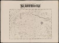
Beinecke Rare Book and Manuscript Library > [Map of Brooklyn, N.Y., showing the battle in this area in 1776, superimposed upon a modern street map.]
Call Number:
Zc20 758Le
Collection Title:
Histoire de la Louisiane : contenant la decouverte de ce vaste pays ; sa description geographique
Image Count:
1
Subject (Geographic):
Louisiana --Description and travel, Louisiana --History --To 1803, Louisiana --Maps --Early works to 1800, Mexico, Gulf of --Discovery and exploration --French, and Mexico, Gulf of --Maps --Early works to 1800
Subject (Topic):
Indians of North America --Mississippi River Valley and Natural history --Louisiana
Collection Created:
Paris : De Bure, l'aine [etc.], 1758
Found in:
Beinecke Rare Book and Manuscript Library > [Map of Louisiana]
Call Number:
1974 +231
Collection Title:
A new and elegant general atlas, comprising all the new discoveries, to the present time
Image Count:
1
Description:
Map 36 from table of contents.
Subject (Geographic):
North America--Maps
Collection Created:
Philadelphia, J. Conrad & co., Baltimore, M. & J. Conrad & co. [etc., etc.] 1804
Found in:
Beinecke Rare Book and Manuscript Library > [Map of North America]
Creator:
Published / Created:
Undated
Call Number:
Taylor 216A
Collection Title:
Iohn Huighen van Linschoten, his Discours of Voyages into ye Easte & West Indies : deuided into
Image Count:
1
Description:
Bound in following title page of second book. and Map has small tear at bottom fold in center.
Subject (Geographic):
Africa --Maps --Early works to 1800, Cape of Good Hope --Maps, Congo (Democratic Republic) --Maps, and Madagascar --Maps --Early works to 1800
Subject (Name):
Wolfe, John, d. 1601, printer
Subject (Topic):
Voyages and travels --Early works to 1800
Collection Created:
[London] : Printed at London by [John Windet for] Iohn Wolfe, printer to ye Honorable Cittie of London, [1598]
Found in:
Beinecke Rare Book and Manuscript Library > [Map of southern Africa and Madagascar]
Published / Created:
Undated
Call Number:
1983 Folio 1
Collection Title:
Chertezhnai'a' kniga Sibiri, sostavlennai'a' tobol'skim synom boi'a'rskim Semenom Remezovym v 1701
Image Count:
1
Resource Type:
Books, Journals & Pamphlets
Subject (Geographic):
China --Maps and Siberia (Russia) --Maps
Subject (Topic):
Great Wall of China (China)
Collection Created:
S.-Peterburg Izdano Arkheograficheskoi'u' kommisiei'u' izhdiveniem P.I. Likhacheva] 1882
Found in:
Beinecke Rare Book and Manuscript Library > [Map of southern Siberia]
Creator:
Call Number:
1974 +231
Collection Title:
A new and elegant general atlas, comprising all the new discoveries, to the present time
Image Count:
1
Description:
Map 57 from table of contents.
Subject (Geographic):
Louisiana Purchase--Pictorial works, Louisiana--Maps--1804, and North America--Maps
Collection Created:
Philadelphia, J. Conrad & co., Baltimore, M. & J. Conrad & co. [etc., etc.] 1804
Found in:
Beinecke Rare Book and Manuscript Library > [Map of the Louisiana Territory]
Call Number:
1974 +231
Collection Title:
A new and elegant general atlas, comprising all the new discoveries, to the present time
Image Count:
1
Description:
Map 37 from table of contents.
Subject (Geographic):
North America--Maps and United States--Maps--1804
Collection Created:
Philadelphia, J. Conrad & co., Baltimore, M. & J. Conrad & co. [etc., etc.] 1804
Found in:
Beinecke Rare Book and Manuscript Library > [Map of the United States of America]
Creator:
Published / Created:
undated
Call Number:
WA MSS S-1741 BrSides
Collection Title:
Colorado Midland Railway Company maps
Container / Volume:
Folder 9
Image Count:
22
Resource Type:
Maps, Atlases & Globes
Description:
Folder also contain 2 MS notes in pencil, 21 cm. and smaller. and Versos blank, not digitized.
Subject (Geographic):
Aspen (Colo.)--Maps, Colorado--Maps, Garfield County (Colo.)--Maps, and Pitkin County (Colo.)--Maps
Subject (Name):
Colorado Midland Railway Company
Subject (Topic):
Mines and mineral resources--Colorado--Maps and Railroads--Colorado--Maps
Found in:
Beinecke Rare Book and Manuscript Library > [Maps of Aspen Branch, Jerome Park Branch, Pitkin-Garfield Counties, Colorado]
Creator:
Published / Created:
undated
Call Number:
WA MSS S-1741 BrSides
Collection Title:
Colorado Midland Railway Company maps
Container / Volume:
Folder 2
Image Count:
10
Resource Type:
Maps, Atlases & Globes
Description:
Folder includes indes of maps on ledger paper, 44 x 56 cm. and Versos blank, not digitized.
Subject (Geographic):
Colorado--Maps, Garfield County (Colo.)--Maps, and Glenwood Springs (Colo.)--Maps
Subject (Name):
Colorado Midland Railway Company
Subject (Topic):
Mines and mineral resources--Colorado--Maps and Railroads--Colorado--Maps
Found in:
Beinecke Rare Book and Manuscript Library > [Maps of Garfield County, Colorado]
Creator:
Published / Created:
undated
Call Number:
WA MSS S-1741 BrSides
Collection Title:
Colorado Midland Railway Company maps
Container / Volume:
Folder 1
Image Count:
8
Resource Type:
Maps, Atlases & Globes
Abstract:
107 colored manuscript railroad maps, detailing the line of the Colorado Midland Railway between Park County and Pitkin and Garfield Counties. The highly detailed maps depict county ranges and townships, survey points and mileage markers, depots, canyons, bridges, sidings, trestles, tunnels, rivers, creeks, etc.; adjacent railroad lines and rights-of-way; hamlets, villages, settlements, ranches, farms, etc.; and plats of the towns of Buena Vista, Leadville, Glenwood Springs, and Aspen. Counties covered are Chaffee, Eagle, Garfield, Lake, Park, and Pitkin. Accompanied by an incomplete index (1 leaf) entitled "Valuation Section [?] Colo. Midland Ry" and two leaves of surveying notes.
Description:
Versos blank, not digitized.
Subject (Geographic):
Colorado--Maps and Garfield County (Colo.)--Maps
Subject (Name):
Colorado Midland Railway Company
Subject (Topic):
Mines and mineral resources--Colorado--Maps and Railroads--Colorado--Maps
Found in:
Beinecke Rare Book and Manuscript Library > [Maps of Garfield County, Colorado]
Branch:v1.65.8 ,Deployed:2025-04-06T22:41:55-04:00