Skip to search
Skip to main content
Skip to first result
Search
You Searched For
Format
cartographic
Search Results
Creator:
Published / Created:
©1909.
Call Number:
771 N49 1664
Container / Volume:
BRBL_00483
Image Count:
1
Resource Type:
Maps, Atlases & Globes
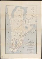
Alternative Title:
Amsterdam in New Netherland, Early New York., and New Amsterdam 1653-1664
Description:
"The personal names are those of the more prominent citizens of that period with the location of their homes."
Publisher:
Townsend MacCoun,
Subject (Geographic):
Manhattan (New York, N.Y.)--History--Colonial period, ca. 1600-1775--Maps, New York (N.Y.)--History--Colonial period, ca. 1600-1775--Maps, and New York (N.Y.)--Maps
Subject (Name):
L.L. Poates Engr'g Co
Found in:
Beinecke Rare Book and Manuscript Library > 1653-1664 Amsterdam in New Netherland [cartographic material] : the city of the Dutch West India Company / by Townsend MacCoun ; L.L. Poates Engr'g. Co.
Creator:
Published / Created:
©1909.
Call Number:
771 N49 1730
Container / Volume:
BRBL_00484
Image Count:
1
Resource Type:
Maps, Atlases & Globes
Alternative Title:
New York 1730 and New York, the English Colonial city
Description:
"The principal points of interest for this period are in red."
Publisher:
Townsend MacCoun,
Subject (Geographic):
Manhattan (New York, N.Y.)--History--Colonial period, ca. 1600-1775--Maps, New York (N.Y.)--History--Colonial period, ca. 1600-1775--Maps, and New York (N.Y.)--Maps
Found in:
Beinecke Rare Book and Manuscript Library > 1730 New York, the English Colonial city / by Townsend MacCoun ; L.L. Poates Engr'g. Co.
Published / Created:
[1909?]
Call Number:
771 N49 1783
Container / Volume:
BRBL_00484
Image Count:
1
Resource Type:
Maps, Atlases & Globes
Publisher:
Townsend Macoon,
Subject (Geographic):
New York (N.Y.)--Maps--Early works to 1800
Found in:
Beinecke Rare Book and Manuscript Library > 1783 Manhattan Island at the close of the Revolution showing the American City with its Landmarks ... Fortifications ... L.L. Poates Engr'g Co., N.Y.
Creator:
Published / Created:
[1878?].
Call Number:
75 1878
Container / Volume:
BRBL_00406
Image Count:
16
Resource Type:
Maps, Atlases & Globes
Alternative Title:
Centennial map of the United States and territories and Centennial map of the United States, 1879.
Description:
Imperfect: Sheet 5 wanting.
Publisher:
J. Bien,
Subject (Geographic):
United States--Maps
Subject (Name):
Bien, Julius, 1826-1909, Roeser, C. (Charles), United States. General Land Office, and Woods, William L
Found in:
Beinecke Rare Book and Manuscript Library > 1876 Centennial map of the United States and territories : showing the extent of public surveys, indian and military reservations, land grant R.R. rail roads, canals, cities, towns & other details / compiled from the official surveys of the General Land O
Creator:
Published / Created:
c1917.
Call Number:
30 1917B
Container / Volume:
BRBL_00032A
Image Count:
1
Resource Type:
Maps, Atlases & Globes
Description:
Caricature map.
Publisher:
s.n.],
Subject (Geographic):
Europe--Maps and Europe--Politics and government--Maps
Subject (Topic):
World War, 1914-1918--Maps
Found in:
Beinecke Rare Book and Manuscript Library > 1914--1915--1916--1917--?? / drawn by J. Lenhard.
Creator:
Published / Created:
[1928]
Call Number:
844 R524 1928
Container / Volume:
BRBL_00607
Image Count:
2
Resource Type:
Maps, Atlases & Globes
Alternative Title:
Map of Riverside and New 1928 map of Riverside, California and road map of Southern California
Description:
"Copyright by Geo. C. Thomas."
Publisher:
Thomas Bros.,
Subject (Geographic):
Riverside (Calif.)--Maps
Subject (Name):
Thomas, Geo. Coupland (George Coupland)
Subject (Topic):
Roads--California, Southern--Maps and Streets--California--Riverside--Maps
Found in:
Beinecke Rare Book and Manuscript Library > 1928 map of Riverside / compiled & published by Thomas Bros.
Creator:
Published / Created:
[1930]
Call Number:
827 1930
Container / Volume:
BRBL_00577
Image Count:
2
Resource Type:
Maps, Atlases & Globes
Alternative Title:
Aeronautical and topographical map of United States. and Oklahoma
Description:
Includes inset of the panhandle, advertisement for "The Oklahoma Farmer-Stockman," and 9 photos.
Publisher:
George F. Cram,
Subject (Geographic):
Oklahoma--Maps
Subject (Topic):
Airways--United States--Maps and Roads--Oklahoma--Maps
Found in:
Beinecke Rare Book and Manuscript Library > 1930 census map of Oklahoma / George F. Cram Company, engravers and publishers.
Creator:
Published / Created:
[1931]
Call Number:
824gmb 1931
Container / Volume:
BRBL_00572
Image Count:
2
Resource Type:
Maps, Atlases & Globes
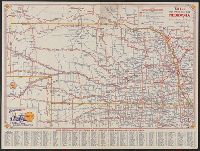
Alternative Title:
1931 road map, Nebraska, Nebraska, and Shell 1931 official road map, Nebraska
Description:
"Shell 1931 official road map, United States" (scale [ca. 1:11,750,000]), distance table, text, and col. ill. on verso.
Publisher:
H.M. Gousha Company,
Subject (Geographic):
Nebraska--Maps
Subject (Name):
Shell Oil Company
Subject (Topic):
Roads--Nebraska--Maps
Found in:
Beinecke Rare Book and Manuscript Library > 1931 official road map, Nebraska / [prepared for] Shell.
Creator:
Published / Created:
[1931]
Call Number:
822gmb 1931
Container / Volume:
BRBL_00567
Image Count:
2
Resource Type:
Maps, Atlases & Globes
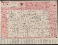
Alternative Title:
1931, North Dakota :, North Dakota, Standard Oil Company (Indiana) 1931 official road map, North Dakota, and Standard Oil Company (Indiana) 1931 official road map, United States.
Description:
"Standard Oil Company (Indiana) 1931 official road map, United States," text, and logos on verso.
Publisher:
H.M. Gousha,
Subject (Geographic):
North Dakota--Maps
Subject (Name):
Standard Oil Company (Indiana)
Subject (Topic):
Roads--North Dakota--Maps
Found in:
Beinecke Rare Book and Manuscript Library > 1931 official road map, North Dakota / this map showing main trunk and highways is distributed with the compliments of Standard Oil Company (Indiana).
Creator:
Published / Created:
[1932]
Call Number:
814gmb 1932
Container / Volume:
BRBL_00559
Image Count:
2
Resource Type:
Maps, Atlases & Globes
Alternative Title:
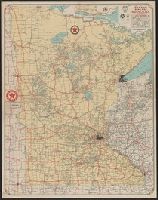
Texaco road map, Minnesota :
Description:
"Texaco road map, 1932, United States," local route maps of Minneapolis-St. Paul and Duluth, distance table, indexes, ill., and text on verso.
Publisher:
Rand McNally and Co.,
Subject (Geographic):
Minnesota--Maps
Subject (Name):
Texas Company
Subject (Topic):
Roads--Minnesota--Maps
Found in:
Beinecke Rare Book and Manuscript Library > 1932 Texaco road map, Minnesota.