Skip to search
Skip to main content
Skip to first result
Search
You Searched For
Repository
Beinecke Rare Book and Manuscript Library
Genre
Early maps
Search Results
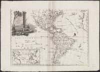
Creator:
Published / Created:
1757
Call Number:
BrSides 2018 139
Image Count:
1
Resource Type:
Maps, Atlases & Globes
Description:
"Tom. XIV. in 4°, no. 9. Tome 14. in 8°, page 97." in lower margin.
Publisher:
[publisher not identified],
Subject (Geographic):
Middle Atlantic States--Maps--Early works to 1800. and New England--Maps--Early works to 1800.
Subject (Name):
La Harpe, Jean-François de, 1739-1803. Abrégé de l'histoire générale des voyages.
Found in:
Beinecke Rare Book and Manuscript Library > Carte de la Nouvelle Angleterre, Nouvelle Yorck, et Pensilvanie / pour servir à l'Histoire générale des voyages. Par M.B., ing. de la mare.
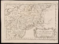
Published / Created:
1st June 1776.
Call Number:
771cea N49 1776
Container / Volume:
BRBL_00493
Image Count:
1
Resource Type:
Maps, Atlases & Globes
Alternative Title:
North-American pilot for New England, New York, Pensilvania, Maryland, and Virginia.
Description:
A Scale of 5 "English Miles" is given below the title at upper left.
Publisher:
Printed for Robt. Sayer & John Bennett, sea chart & map-sellers, No. 53, in Fleet Street. Published as the Act directs,
Subject (Geographic):
Atlantic Ocean--Lower Bay, Atlantic Ocean--Upper Bay, New Jersey--Sandy Hook, New York Harbor (N.Y. and N.J.) Maps--Early works to 1800., New York Region--Maps--Early works to 1800., and Sandy Hook (N.J.)
Subject (Name):
Robert Sayer and John Bennett (Firm), printmaker, printseller
Subject (Topic):
Nautical charts, Nautical charts--Hudson River Estuary (N.Y. and N.J.)--Early works to 1800., Nautical charts--Lower Bay (N.Y. and N.J.)--Early works to 1800., and Nautical charts--Upper Bay (N.Y. and N.J.)--Early works to 180
Found in:
Beinecke Rare Book and Manuscript Library > Chart of the entrance of Hudson's River, from Sandy Hook to New York [cartographic material] : with the banks, depths of water, sailing-marks, & ca.
Creator:
Published / Created:
1 June 1775.
Call Number:
BrSides Folio 2018 122
Image Count:
1
Resource Type:
Maps, Atlases & Globes
Alternative Title:
Course of the river Mississippi from the Balise to Fort Chartres
Description:
From Thomas Jeffery's The American atlas. 1775. Also published in Faden's North America Atlas, 1777.
Publisher:
Printed for Robt. Sayer, No. 53 in Fleet Street. Publishd as the Act directs,
Subject (Geographic):
Mississippi River Valley--Maps--Early works to 1800. and Mississippi River--Maps--Early works to 1800.
Subject (Name):
Jefferys, Thomas, -1771. American atlas. and Sayer, Robert, 1725-1794
Found in:
Beinecke Rare Book and Manuscript Library > Course of the river Mississipi [sic] from the Balise to Fort Chartres [cartographic material] ; taken on an expedition to the Illinois, in the latter end of the year 1765. / By Lieut. Ross of the 34th Regiment: Improved from the surveys of the river made
Creator:
Published / Created:
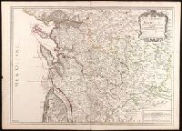
1722
Call Number:
BrSides Double Folio 2019 86
Image Count:
1
Resource Type:
Maps, Atlases & Globes
Description:
Appeared in Alexis Hubert Jaillot's Atlas
Publisher:
Chez l'auteur, le Sr. Jaillot, Geographe ordinaire du Roy, avec Privilege de sa Majesté,
Subject (Geographic):
Charente-Maritime (France)--Administrative and political divisions--Maps--Early works to 1800. and Charente-Maritime (France)--Maps--Early works to 1800.
Subject (Name):
Haye, G. de la and Jaillot, Alexis Hubert, 1632?-1712. Atlas françois.
Subject (Topic):
Administrative and political divisions.
Found in:
Beinecke Rare Book and Manuscript Library > Generalité de La Rochelle divisée en cinq elections : sçavoir La Rochelle dans le pays d'Aunis, St. Jean d'Angely, Saintes, Marennes en Saintonge, Cognac en Angoumois : dressée sur les memoires les plus nouveaux / par le Sr. Jaillot ; Delahaye sculpsit.
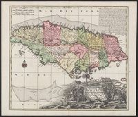
Creator:
Published / Created:
1740?]
Call Number:
8555 1740
Container / Volume:
BRBL_00642
Image Count:
1
Resource Type:
Maps, Atlases & Globes
Description:
Appears in: Atlas novus, sive tabulae geographicae totius orbis faciem, partes, imperia et provincias exhibentes ... Augsburg : Matthaeo Seuttero, [1745?] 2 v. (Vol. 1, map no. 143).
Publisher:
[M. Seutter,
Subject (Geographic):
Jamaica--Maps--Early works to 1800
Subject (Name):
Seutter, Matthaeus, 1678-1756. Atlas novus, sive tabulae geographicae totius orbis faciem, partes, imperia et provincias exhibentes
Found in:
Beinecke Rare Book and Manuscript Library > Nova designatio Insulae Jamaicae [cartographic material] : ex Antillanis Americae Septentrion. non postremae / secundum gubernationes suas accuratas aeri incisa et publici juris facta a Matthaeo Seuttero, Sac. Caes. et Reg. Cathol. Maj. Geogr.
Creator:
Published / Created:
[1767]
Call Number:
50 1767
Container / Volume:
BRBL_00271
Image Count:
1
Resource Type:
Maps, Atlases & Globes
Description:
Cartographer and publication date from dealer's notes.
Publisher:
[publisher not identified],
Subject (Geographic):
Middle East--Maps--Early works to 1800, Palestine--History--To 70 A.D.--Maps--Early works to 1800, and Palestine--Maps--Early works to 1800
Subject (Name):
Le Tellier, engraver
Subject (Topic):
Bible--Geography--Maps--Early works to 1800
Found in:
Beinecke Rare Book and Manuscript Library > Partie Orientale de la carte des anciennes monarchies [cartographic material] : omnis anima potestatibus sublimioribus subdita sit : non est enim potestas nisi à Deo : quae autem sunt, à Deo ordinatae sunt Aux Romains, ch. XIII. v.I / gravé par Le Tell