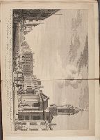
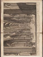
Page 155. New London spy, or, A twenty-four hours ramble through the bills of mortality.
Image Count:
1
Resource Type:
still image
Abstract:
View on George Street, looking towards the square, St. George's Church on the right with large Corinthian portico, fat farmer driving sheep in street at center, sedan chair to right
Alternative Title:
View of Saint Georges Church, Hanover Square, from Conduit Street, London and Vuë de l'Eglise de Saint George dans le Carré de Hanover, prés du Côté Rue Conduit à Londres
Description:
Titles engraved below image, in English and French.
Publisher:
Printed for T. Jefferys, the corner of St. Martins Lane, Charing Cross
Subject (Geographic):
England, London, London (England), and London.
Subject (Name):
St. George's Church (Westminster, London, England),
Subject (Topic):
Church buildings, Plazas, Churches, City & town life, Sedan chairs, and Herders
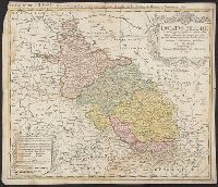
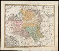
Dvcatvs Silesiae tabula geographica generalis, Duché de Silesie suivant l'état présent dresé par Tobie Maier, et publié par les Héritiers de Homann a Nuremberg, and Dvché de Silesie suivant l'état présent dresé par Tobie Maier, et publié par les Héritiers de Homann a Nuremberg
Description:
BEIN 3616 1749A: Mounted within later paper border.
Publisher:
Impensis Homannianorum Heredum
Subject (Geographic):
Silesia (Czech Republic), Czech Republic, and Silesia.
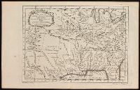
Chez l'auteur, le Sr. Jaillot, Geographe ordinaire du Roy, avec Privilege de sa Majesté,
Subject (Geographic):
Charente-Maritime (France)--Administrative and political divisions--Maps--Early works to 1800. and Charente-Maritime (France)--Maps--Early works to 1800.
Subject (Name):
Haye, G. de la and Jaillot, Alexis Hubert, 1632?-1712. Atlas françois.
BEIN Mzd45 H6 1509: Hand-ruled and rubricated throughout; capitals supplies in gold on red and blue backgrounds. Hand-colored illustrations are: the printer's device on page [1], the skeleton and surrounding figures on page [2], full-page illustration...
BEIN Mzd45 H6 1509: Hand-ruled and rubricated throughout; capitals supplies in gold on red and blue backgrounds. Hand-colored illustrations are: the printer's device on page [1], the skeleton and surrounding figures on page [2], full-page illustration...
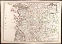
"La couleure violette marque les pays démembrés de la Pologne en 1772, conformément aux prétensions des trois Puissances voisines."--Lower left margin.
Publisher:
Luci publicae tradita per Homannianos Heredes
Subject (Geographic):
Belarus--Maps--Early works to 1800., Lithuania--Maps--Early works to 1800., Poland--Maps--Early works to 1800., and Ukraine--Maps--Early works to 1800.
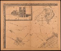
Grand plan de Paris et de ses environs, Paris et ses environs., Réproductions d'anciens plans de Paris, and Réproductions d'anciens plans de Paris ; [7].
Description:
"En vente, chez le sieur de Richesource, en place Daufine, à la Renomé. Publiée en 9 feuilles, accompagné d'une notice de M.A. Bonnardot"--Cover.
Publisher:
A. Taride,
Subject (Geographic):
France--Paris, France--Paris Region, Paris (France)--Maps--Early works to 1800--Facsimiles., and Paris Region (France)--Maps.
Subject (Name):
Bonnardot, A. (Alfred). Grand plan de Jouvin de Rochefort., Cartes Taride (Firm), and La Pointe, François de.