North-American pilot for New England, New York, Pensilvania, Maryland, and Virginia.
Description:
A Scale of 5 "English Miles" is given below the title at upper left.
Publisher:
Printed for Robt. Sayer & John Bennett, sea chart & map-sellers, No. 53, in Fleet Street. Published as the Act directs,
Subject (Geographic):
Atlantic Ocean--Lower Bay, Atlantic Ocean--Upper Bay, New Jersey--Sandy Hook, New York Harbor (N.Y. and N.J.) Maps--Early works to 1800., New York Region--Maps--Early works to 1800., and Sandy Hook (N.J.)
Subject (Name):
Robert Sayer and John Bennett (Firm), printmaker, printseller
Subject (Topic):
Nautical charts, Nautical charts--Hudson River Estuary (N.Y. and N.J.)--Early works to 1800., Nautical charts--Lower Bay (N.Y. and N.J.)--Early works to 1800., and Nautical charts--Upper Bay (N.Y. and N.J.)--Early works to 180
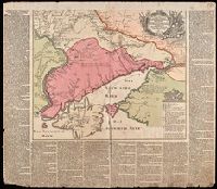
Nachricht von denen gegen die Türcken und Tartarn in diesem 1736sten Jahre vorgefallenen Kriegs-Operationen der Russisch-Kayserlichen Armée.
Description:
Imperfect: chipped along edges, with some loss of text. Reinforced with paper at top. Manuscript number 76 in upper right corner. Manuscript waste pasted to verso. From the Karpinski-von Wieser Map Collection.
Publisher:
Zu haben bey Matthaeus Seutter
Subject (Geographic):
Russia--History, Military--18th century--Maps--Early works to 1800., Ukraine, Ukraine--History, Military--18th century--Maps--Early works to 1800., and Ukraine--Maps--Early works to 1800.
Subject (Name):
Imperatorskai︠a︡ akademīi︠a︡ nauk (Russia) and Russo-Turkish War (1736-1739)
Subject (Topic):
Military campaigns and Russo-Turkish War, 1736-1739--Campaigns--Ukraine--Maps--Early works to 1800.
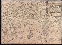
Afbeeldinge der custen van Abex, der engte van Mecha, anders ghenaempt de Roode Zee, Item de custen van Arabien, Ormus, Persen tot Sinde toe and Deliniantur in hac tabula, Orae maritimae Abexiae, freti Mecani ; al. Maris Rubri ; Arabiae, Ormi, Persiae, suprà Sindam usque Fluminis Indi, Cambaiae Indiae et Malabaris, Insulae Ceylon, Choromandeliae, et Orixae, fluvii Gangis, et Regni Bengalae, situs item Sinuum, Insularum
Description:
Backed with paper.
Publisher:
[Cornelis Claesz?],
Subject (Geographic):
Africa, Eastern--Maps--Early works to 1800., India--Maps--Early works to 1800., and Iran--Maps--Early works to 1800.
Subject (Name):
Langren, Henricus F. ab (Henricus Florentius), approximately 1574-1648. and Linschoten, Jan Huygen van, 1563-1611. Itinerario, voyage ofte schipvaert van Jan. Huygen van Linschoten naer Oost ofte Portugaels Indien.
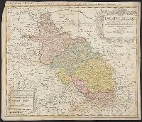
Dvcatvs Silesiae tabula geographica generalis, Duché de Silesie suivant l'état présent dresé par Tobie Maier, et publié par les Héritiers de Homann a Nuremberg, and Dvché de Silesie suivant l'état présent dresé par Tobie Maier, et publié par les Héritiers de Homann a Nuremberg
Description:
BEIN 3616 1749A: Mounted within later paper border.
Publisher:
Impensis Homannianorum Heredum
Subject (Geographic):
Silesia (Czech Republic), Czech Republic, and Silesia.
Voyage autour du monde par la frégate du Roi la Boudeuse, et la flûte l'Etoile, en 1766, 1767, 1768
Image Count:
1
Resource Type:
Maps, Atlases & Globes
Description:
In French.
Publisher:
[De l'imprimerie de Le Breton ...],
Subject (Name):
Boudeuse (Frigate), Bougainville, Louis-Antoine de, comte, 1729-1811. Voyage autour du monde : par la frégate du Roi la Boudeuse, et la flûte l'Etoile, en 1766, 1767, 1768, & 1769., Etoile (Ship), and Saillant & Nyon.
Subject (Topic):
Voyages around the world--Early works to 1800. and World maps.
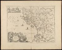
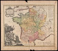
France Benedictine, ou carte generale des abbayes, & prieurez conventuels de l'Ordre de S. Benoit, tant d'hommes, que de filles, au jour a Norimberg, a 1738
Description:
Bottom left shows St. Maurice offering a book of prayers to Theodebert I, King of France who answers: "Plura Maurus precibus quam Nos Armis."
Publisher:
Recude[n]tibus Homan[n]ian. Heredib
Subject (Geographic):
France--Maps--Early works to 1800.
Subject (Name):
Homann Erben (Firm)
Subject (Topic):
Benedictine monasteries--France--Maps--Early works to 1800., Benedictine nuns--France--Maps--Early works to 1800., Convents, and Convents--France--Maps--Early works to 1800.
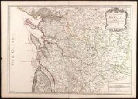
Chez l'auteur, le Sr. Jaillot, Geographe ordinaire du Roy, avec Privilege de sa Majesté,
Subject (Geographic):
Charente-Maritime (France)--Administrative and political divisions--Maps--Early works to 1800. and Charente-Maritime (France)--Maps--Early works to 1800.
Subject (Name):
Haye, G. de la and Jaillot, Alexis Hubert, 1632?-1712. Atlas françois.