Skip to search
Skip to main content
Skip to first result
Search
You Searched For
Genre
Manuscript maps
New Search
Search Results
Published / Created:
1745
Call Number:
36 P471 1745
Container / Volume:
BRBL_00702
Image Count:
1
Resource Type:
Maps, Atlases & Globes
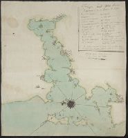
Description:
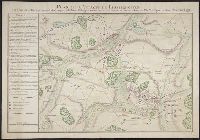
Key in left hand corner. and Manuscript in French and German.
Subject (Geographic):
Germany--Maps, Manuscript--Early works to 1800
Found in:
Beinecke Rare Book and Manuscript Library > Plan de L'Attaque de Pfaffenhoffen. Faite par Mr. de Batiany ... 1745.
Published / Created:
1721
Call Number:
795 N47 1721
Container / Volume:
BRBL_00716
Image Count:
1
Resource Type:
Maps, Atlases & Globes
Description:
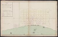
[Drawn by Pauger?] and Color: green and yellow with some red detail.
Subject (Geographic):
New Orleans (La.)--Maps--Early works to 1800
Found in:
Beinecke Rare Book and Manuscript Library > Plan de la Nouvelle Orleans Scituée sur le Fleuve St. Louis ... 1721.
Published / Created:
[1770?]
Call Number:
37 G28 1770
Container / Volume:
BRBL_00703
Image Count:
1
Resource Type:
Maps, Atlases & Globes
Description:
Color: Olive green and some red detail. and Preliminary record.
Subject (Geographic):
Geneva (Switzerland)--Maps, Manuscript--Early works to 1800
Found in:
Beinecke Rare Book and Manuscript Library > Plan de la ville de Geneve.
Published / Created:
[1788?]
Call Number:
BrSides Folio 2019 52
Image Count:
1
Resource Type:
Maps, Atlases & Globes
Description:
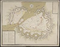
Includes inset map: "Sieg der russisch kaiserlichen Truppen über die Türken bey Gangura". and Relief shown pictorially.
Subject (Geographic):
Bender (Moldova)--Maps--Early works to 1800.
Subject (Topic):
Fortification--Moldova--Bender--Maps--Early works to 1800.
Found in:
Beinecke Rare Book and Manuscript Library > Plan der Festung Bender : A. nachdem die russisch kaiserliche Truppen unter Commando des General Kamenskoy in 3 Colonnen die Türke bey B. in Gangura und bey C. Salkuza den 20 December 1788 überfallen und in die Flucht geschlagen ...
Published / Created:
[1810]
Call Number:
36hc D625 1810
Container / Volume:
BRBL_00703
Image Count:
1
Resource Type:
Maps, Atlases & Globes
Subject (Geographic):
Germany--Maps, Manuscript--Early works to 1800
Found in:
Beinecke Rare Book and Manuscript Library > Plan der Position de Corps d'Armee bey Dippoldiswalda [Saxony] unter Comando Sr. Excell. des Herrn Gen: Feld- Zeug- Meister Grafen v. Wied. Desineé par J.C. v. John et Ingen.
Published / Created:
[1710]
Call Number:
39hc V68 1710
Container / Volume:
BRBL_00703
Image Count:
1
Resource Type:
Maps, Atlases & Globes
Description:
Color: Original pen and water color drawing, blue and green., Key in upper right hand corner., and Military map of the Fjord of Vigo on the Galician coast, with the fortresses of Bayona and Vigo on the south bank, Vigo being located further inland. The outlines of the land and of the islands in the fjord are pin-holed for tracing purposes. Buildings representing residential areas, chapel covents, etc. are drawn in full whereas the two fortresses are depicted as ground-plan.
Subject (Geographic):
Spain--Maps, Manuscript--Early works to 1800
Found in:
Beinecke Rare Book and Manuscript Library > Plan des Isles de Bayonne et de la riviere de Vigue.
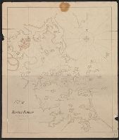
Published / Created:
[1756?]
Call Number:
771 T43 1756
Container / Volume:
BRBL_00714
Image Count:
1
Resource Type:
Maps, Atlases & Globes
Subject (Geographic):
Fort Ticonderoga (N.Y.)--Maps--Early works to 1800
Found in:
Beinecke Rare Book and Manuscript Library > Plan du fort de Carilion en Canada, construit par les troupes francoises en 1756.
Published / Created:
[1804?]
Call Number:
764 B65 1804
Container / Volume:
BRBL_00710
Image Count:
1
Resource Type:
Maps, Atlases & Globes
Description:
Depths shown by soundings.
Subject (Geographic):
Boston Harbor (Mass.)--Maps
Found in:
Beinecke Rare Book and Manuscript Library > Plan of Boston Harbor, from actual survey.
Published / Created:
1753
Call Number:
764 G297 1753
Container / Volume:
BRBL_00710
Image Count:
1
Resource Type:
Maps, Atlases & Globes
Description:
Color: pen and ink drawing.
Subject (Geographic):
Massachusetts--Maps, Manuscript--Early works to 1800
Found in:
Beinecke Rare Book and Manuscript Library > Plan of George's Island [in Boston Harbor].
Published / Created:
[1800?]
Call Number:
399cea 1800
Container / Volume:
BRBL_00704
Image Count:
1
Resource Type:
Maps, Atlases & Globes
Description:
Color: Pen drawing. and Key in upper left hand corner.
Subject (Geographic):
Gibraltar--Maps, Manuscript--Early works to 1800
Found in:
Beinecke Rare Book and Manuscript Library > Plan of Gibraltar Bay.
Branch:v1.65.7 ,Deployed:2025-02-26T12:12:05-05:00