Skip to search
Skip to main content
Skip to first result
Search
You Searched For
Genre
Manuscript maps.
Search Results
Published / Created:
[1792?]
Call Number:
771 D37 1792F
Image Count:
1
Resource Type:
Maps, Atlases & Globes
Alternative Title:
Map of the Franklin patent
Description:
Coordinates not present on map and are approximated.
Subject (Geographic):
Delaware County (N.Y.)--Maps.
Subject (Topic):
Real property--New York (State)--Delaware County--Maps.
Found in:
Beinecke Rare Book and Manuscript Library > A map of the Franlin patient.
Creator:
Call Number:
Manuscript 911cea 1789
Image Count:
2
Resource Type:
Maps, Atlases & Globes
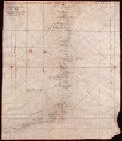
Description:
Color: red and black ink, longitude and latitude grid colored yellow.
Subject (Geographic):
Brazil--Maps--Early works to 1800.
Subject (Topic):
Coasts--Brazil--Maps--Early works to 1800.
Found in:
Beinecke Rare Book and Manuscript Library > Carta reduzida de hua parte de costa do Brasil : desde o Morro de S. Paulo athê Santos / por José Fernandes, Portugal na Bahia de Todos os Santos no Anno de 1789.
Creator:
Published / Created:
[1830?]
Call Number:
Small Manuscript 594 J18 1830
Image Count:
1
Resource Type:
Maps, Atlases & Globes
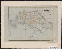
Description:
Added by hand in upper right margin: Yale College Library, from Professor E.E. Salisbury, 1870.
Subject (Geographic):
Jaffna (Sri Lanka)--Maps.
Subject (Name):
Salisbury, Edward Elbridge,--1814-1901--Ownership. and Yale College (1718-1887). Library Ownership.
Found in:
Beinecke Rare Book and Manuscript Library > Jaffna, by R. Breckenridge.
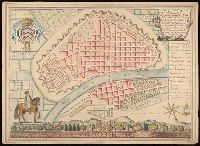
Published / Created:
[between 1870 and 1879?]
Call Number:
BrSides Folio 2018 125
Image Count:
1
Resource Type:
Maps, Atlases & Globes
Description:
"Scale 200 feet to 1 inch."
Subject (Topic):
Mines and mineral resources--Utah--Maps.
Found in:
Beinecke Rare Book and Manuscript Library > Map of the Miners Dream and Vanderbelt consd. mines in West Mountain Mining District, Salt Lake County, U.T.
Creator:
Published / Created:
1878
Call Number:
766 St71 1878
Image Count:
1
Resource Type:
Maps, Atlases & Globes
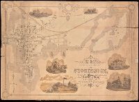
Description:
Includes illustrations of local buildings.
Publisher:
George D. Stanton and H. Clay Palmer,
Subject (Geographic):
Stonington (Conn.)--Maps. and Stonington (Conn.)--Pictorial works.
Subject (Name):
Palmer, H. Clay, cartographer.
Subject (Topic):
Buildings--Connecticut--Stonington--Pictorial works. and Real property--Connecticut--Stonington--Maps.
Found in:
Beinecke Rare Book and Manuscript Library > Map of the borough of Stonington, Conn. / surveyed and drawn by George D. Stanton and H. Clay Palmer.
Published / Created:
1907
Call Number:
92b 1907
Container / Volume:
BRBL_00721
Image Count:
1
Resource Type:
Maps, Atlases & Globes
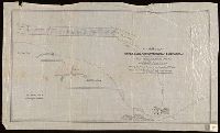
Description:
Bar scales given in "Leguas Argentinas" and "Kilometros."
Subject (Geographic):
Corrientes (Argentina : Province)--Maps.
Subject (Topic):
Real property--Argentina--Corrientes (Province)--Maps.
Found in:
Beinecke Rare Book and Manuscript Library > Map of the northern portion of Corrientes Province in Argentina.
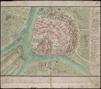
Published / Created:
An[n]o 1790.
Call Number:
97 L62 1790
Container / Volume:
BRBL_00721
Image Count:
1
Resource Type:
Maps, Atlases & Globes
Description:
Bar scale given in "Escala de 500 Tuasas."
Subject (Geographic):
Lima (Peru)--Maps--Early works to 1800.
Found in:
Beinecke Rare Book and Manuscript Library > Plan de Lima capital del Peru, dedicado al Exmo. Sor Marques del Campo Caballero del orden de Carlos III ...
Published / Created:
[1730?]
Call Number:
BrSides Double Folio 2019 74
Image Count:
1
Resource Type:
Maps, Atlases & Globes
Description:
In manuscript in upper right corner: "90".
Subject (Geographic):
Belgrade (Serbia)--Maps--Early works to 1800.
Found in:
Beinecke Rare Book and Manuscript Library > Plan von Belgrad sambt denen neuen Projecten wie solcher von Ihro Kayserlichen Maiestät aller Gnädigist approbiert, unterzeichnet und würklich tractieret worden.
Creator:
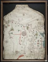
Published / Created:
no anno dominus nostris Jh[es]u Xpi de 1492.
Call Number:
Art Storage 30cea 1492
Image Count:
2
Resource Type:
Maps, Atlases & Globes
Description:
Contains seven compass roses.
Subject (Geographic):
Black Sea--Maps--Early works to 1800., Mediterranean Sea--Maps--Early works to 1800., and North Atlantic Ocean--Maps--Early works to 1800.
Subject (Topic):
Nautical charts--Black Sea--Early works to 1800., Nautical charts--Mediterranean Sea--Early works to 1800., and Nautical charts--North Atlantic Ocean--Early works to 1800.
Found in:
Beinecke Rare Book and Manuscript Library > Portolan chart of the Mediterranean Sea, the North Atlantic Ocean, the Black Sea, and the West African coast as far south as Sierra Leone.
Creator:
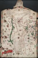
Published / Created:
[1505]
Call Number:
Art Storage 30cea 1505
Image Count:
2
Resource Type:
Maps, Atlases & Globes
Description:
Contains six compass roses.
Subject (Geographic):
Black Sea--Maps--Early works to 1800., Mediterranean Sea--Maps--Early works to 1800., and North Atlantic Ocean--Maps--Early works to 1800.
Subject (Topic):
Nautical charts--Black Sea--Early works to 1800., Nautical charts--Mediterranean Sea--Early works to 1800., and Nautical charts--North Atlantic Ocean--Early works to 1800.
Found in:
Beinecke Rare Book and Manuscript Library > Portolan chart of the Mediterranean Sea, the North Atlantic Ocean, the Black Sea, and the northwestern African coast.