Search
You Searched For
Search Results
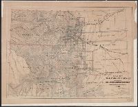
- Creator:
- Clason Map Co
- Published / Created:
- c1911.
- Call Number:
- 834 1911A
- Container / Volume:
- BRBL_00588
- Image Count:
- 4
- Resource Type:
- Maps, Atlases & Globes
- Alternative Title:
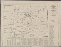
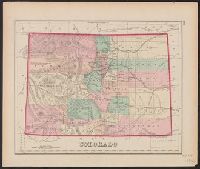
- State of Colorado
- Description:
- Index of cities and towns with elevation keyed to map.
- Publisher:
- Clason Map Co.,
- Subject (Geographic):
- Colorado--Maps
- Found in:
- Beinecke Rare Book and Manuscript Library > Clason's sectional map, state of Colorado.
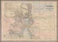
- Creator:
- American Map Company (New York, N.Y.)
- Published / Created:
- [1931].
- Call Number:
- 834 1931A
- Container / Volume:
- BRBL_00588
- Image Count:
- 1
- Resource Type:
- Maps, Atlases & Globes
- Alternative Title:
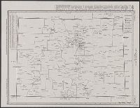
- County-town map of Colorado
- Description:
- Below title: Map no. 405.
- Publisher:
- American Map Company,
- Subject (Geographic):
- Colorado--Administrative and political divisions--Maps and Colorado--Maps
- Found in:
- Beinecke Rare Book and Manuscript Library > Cleartype county-town map of Colorado.
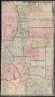
- Creator:
- Rand McNally and Company
- Published / Created:
- [1950?]
- Call Number:
- 834fb 1950
- Container / Volume:
- BRBL_00590
- Image Count:
- 1
- Resource Type:
- Maps, Atlases & Globes
- Description:
- "Engraved and indexed for use with the Rand McNally commercial atlas and marketing guide."
- Publisher:
- The Company,
- Subject (Geographic):
- Colorado--Administrative and political divisions--Maps and Colorado--Maps
- Found in:
- Beinecke Rare Book and Manuscript Library > Colorado : city-county state map / [by] Rand McNally.
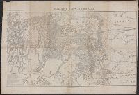
- Creator:
- Gray, Ormando Willis
- Published / Created:
- 1874?]
- Call Number:
- 834 1874A
- Container / Volume:
- BRBL_00587
- Image Count:
- 1
- Resource Type:
- Maps, Atlases & Globes
- Description:
- In upper right-hand margin: 132.
- Publisher:
- Stedman, Brown & Lyon?,
- Subject (Geographic):
- Colorado--Maps
- Subject (Name):
- Gray, Ormando Willis. Gray's atlas of the United States and Stedman, Brown & Lyon
- Found in:
- Beinecke Rare Book and Manuscript Library > Colorado.
- Creator:
- Jeppesen Map Co
- Published / Created:
- 1950]
- Call Number:
- 834ag 1950
- Container / Volume:
- BRBL_00590
- Image Count:
- 1
- Resource Type:
- Maps, Atlases & Globes
- Alternative Title:
- Colorado wonderland map
- Description:
- Relief shown by shading and spot heights.
- Publisher:
- The Co.,
- Subject (Geographic):
- Colorado--Maps
- Found in:
- Beinecke Rare Book and Manuscript Library > Jeppesen's Colorado wonderland map / [Jeppesen Map Co.].
- Creator:
- Kibbe, A. F
- Published / Created:
- 1881
- Call Number:
- 834 1881A
- Container / Volume:
- BRBL_00587
- Image Count:
- 1
- Resource Type:
- Maps, Atlases & Globes
- Alternative Title:
- Geographical and geological map of the San Juan Mining Region, Colorado
- Description:
- "Entered according to Act of Congress, 1881 by A.F. Kibbe in the office of the Librarian of Congress at Washington."
- Publisher:
- Geo. H. Adams & Son,
- Subject (Geographic):
- Colorado--Maps
- Subject (Name):
- American Photo-Lithographic Company and Geo. H. Adams & Son
- Found in:
- Beinecke Rare Book and Manuscript Library > Kibbe's geographical and geological map of the San Juan Mining Region, Colorado / A.F. Kibbe.
- Creator:
- Hollister, Ovando James, 1834-1892
- Published / Created:
- 1866
- Call Number:
- 834 1866
- Container / Volume:
- BRBL_00587
- Image Count:
- 1
- Resource Type:
- Maps, Atlases & Globes
- Alternative Title:
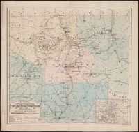
- Colorado Territory to accompany Hollisters "Mines of Colorado"
- Description:
- Relief shown by hachures.
- Publisher:
- The Major & Knapp Engraving, Manufg and Lithographic Co.,
- Subject (Geographic):
- Colorado--Maps
- Subject (Name):
- Hollister, Ovando James, 1834-1892. Mines of Colorado and Major & Knapp Engraving, Manufacturing & Lithographic Co
- Subject (Topic):
- Coal--Colorado--Maps, Gold mines and mining--Colorado--Maps, and Silver mines and mining--Colorado--Maps
- Found in:
- Beinecke Rare Book and Manuscript Library > Map of Colorado Territory to accompany Hollisters "Mines of Colorado" corrected from the Public Surveys of 1866.
- Creator:
- Ebert, Frederick J
- Published / Created:
- 1865, c1862
- Call Number:
- 834 1865
- Container / Volume:
- BRBL_00587
- Image Count:
- 1
- Resource Type:
- Maps, Atlases & Globes
- Description:
- Relief shown by hachures.
- Publisher:
- Jacob Monk,
- Subject (Geographic):
- Colorado--Maps
- Subject (Name):
- Monk, Jacob
- Found in:
- Beinecke Rare Book and Manuscript Library > Map of Colorado territory, shewing the system of parks / drawn by Frederick J. Ebert.
- Creator:
- Bonsall, J. H
- Published / Created:
- 1872
- Call Number:
- 834 1872
- Container / Volume:
- BRBL_00587
- Image Count:
- 2
- Resource Type:
- Maps, Atlases & Globes
- Description:
- Includes 7 town plans and "Map of Denver, Arapahoe Co., Colorado," "[Map of] Central City and vicinity," and "[Map of] Colorado."
- Publisher:
- Bonsall and Kellogg,
- Subject (Geographic):
- Colorado--Maps
- Subject (Name):
- Kellogg, E. H
- Found in:
- Beinecke Rare Book and Manuscript Library > Map of Colorado, with plans of its principal towns / compiled from official authorities by J.H. Bonsall and E.H. Kellogg.
- Creator:
- De Werthern, H
- Published / Created:
- 1869]
- Call Number:
- 836 1869
- Container / Volume:
- BRBL_00592
- Image Count:
- 1
- Resource Type:
- Maps, Atlases & Globes
- Description:
- "Bvt. Maj. Gen. A.A. Humphreys, Chief of Engineers."
- Publisher:
- s.n.,
- Subject (Geographic):
- Colorado--Maps and Utah--Maps
- Subject (Name):
- Humphreys, A. A. (Andrew Atkinson), 1810-1883, Merrill, Wm. F, R.P. Studley Co, and Sherman, William T. (William Tecumseh), 1820-1891
- Found in:
- Beinecke Rare Book and Manuscript Library > Map of Utah and Colorado / prepared by order of Lieut. Genl. W.T. Sherman ; drawn by H. De Werthern.