Skip to search
Skip to main content
Skip to first result
Search
You Searched For
Genre
Maps
Subject (Topic)
Maps
Search Results
Creator:
Published / Created:
1943.
Call Number:
36gma 1943
Image Count:
1
Description:
"Map no. 1994, 25 August 1943."
Publisher:
Lithographed in the Reproduction Branch, OSS
Subject (Geographic):
Europe, Central and Germany
Subject (Topic):
Inland navigation and Maps
Found in:
Beinecke Rare Book and Manuscript Library > "Greater Germany" inland waterways
Creator:
Published / Created:
1945.
Call Number:
36eb 1945B
Image Count:
1
Description:
"No. 6381-R & A, OSS, 28 April 1945."
Publisher:
R & A, OSS
Subject (Geographic):
Germany and Europe, Central
Subject (Topic):
Population and Maps
Found in:
Beinecke Rare Book and Manuscript Library > "Greater" Germany, density of total population by Kreise or similar units excluding cities 10,000 and over
Creator:
Published / Created:
MDCCLXXX [1780]
Call Number:
1973 +100
Image Count:
1
Resource Type:
cartographic image
Description:
Coordinates based on index map ([1] leaf of plates).
Publisher:
James Rennell
Subject (Geographic):
Bengal (India), Bihar and Orissa (India), India, Bengal., and Bihar and Orissa.
Subject (Topic):
Maps
Found in:
Beinecke Rare Book and Manuscript Library > A Bengal atlas : containing maps of the theatre of war and commerce on that side of Hindoostan
Creator:
Published / Created:
1785.
Call Number:
1977 Folio 177
Image Count:
2
Description:
BEIN 1977 Folio 177: Imperfect: left sheet wanting. Right sheet measures 64.2 x 48.0 cm. Ms. note at head of title: Cook's voyages. Ms. note on verso: Map of Cook's last voyage. No. 12 of 34 maps bound together.
Publisher:
Printed for J. Bew
Subject (Name):
Cook, James, 1728-1779
Subject (Topic):
Travel, Maps, Voyages around the world, and World maps
Found in:
Beinecke Rare Book and Manuscript Library > A general chart exhibiting the discoveries made by Captn. James Cook in this and his two preceeding voyages with the tracks of the ships under his command [cartographic material]
Creator:
Published / Created:
[1698]
Call Number:
Zc20 697heg
Collection Title:
Map [1]. New discovery of a vast country in America.
Image Count:
1
Resource Type:
cartographic image
Description:
Relief shown pictorially.
Publisher:
Printed for M. Bentley, J. Tonson, H. Bonwick, T. Goodwin, and S. Manship
Subject (Geographic):
North America, Mississippi River Valley, Mississippi River Valley., and North America.
Subject (Topic):
Maps
Found in:
Beinecke Rare Book and Manuscript Library > A map of a large country newly discovered in the Northern America situated between New Mexico and the frozen sea together with the course of the great river Meschasipi / [cartographic material]
Creator:
Published / Created:
[1755 or 1759?]
Call Number:
2003 Folio 85
Image Count:
1
Resource Type:
cartographic image
Description:
BEIN Roll Map 194: Imperfect: somewhat brittle, chipped, torn in places, with minimal loss of map image. Joined sheets measure 100 x 109 cm. Mounted on linen. In manuscript on verso: Jefferys's Map of New England 1755.
Publisher:
Thomas Jefferys
Subject (Geographic):
New England, New England., and United States New England. lcsh
Subject (Topic):
Maps
Found in:
Beinecke Rare Book and Manuscript Library > A map of the most inhabited part of New England : containing the provinces of Massachusets Bay and New Hampshire, with the colonies of Conecticut and Rhode Island, divided into counties and townships : the whole composed from actual surveys and its situation adjusted by astronomical observations
Creator:
Published / Created:
[1755]
Call Number:
2003 Folio 85
Image Count:
1
Description:
BEIN 2003 Folio 85: No. 21 of 45 maps bound together with binder's spine title: Atlas of America; ms. table of contents. Bookplate: Robinson. Bookplate of Paul Mellon.
Publisher:
Thos. Jeffreys
Subject (Geographic):
Virginia, Maryland, and Middle Atlantic States
Subject (Topic):
Maps
Found in:
Beinecke Rare Book and Manuscript Library > A map of the most inhabited part of Virginia containing the whole province of Maryland : with part of Pensilvania, New Jersey and North Carolina
Creator:
Published / Created:
1748.
Call Number:
60 1748
Image Count:
1
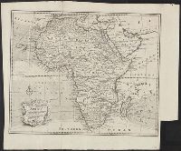
Description:
Relief shown pictorially.
Publisher:
s.n.
Subject (Geographic):
Africa
Subject (Topic):
Maps
Found in:
Beinecke Rare Book and Manuscript Library > A new and correct map of Africa : drawn from the most approved modern maps and charts, and adjusted by astronomical observations, representing also the course of the trade winds, monsoons, &c.
Creator:
Published / Created:
1755.
Call Number:
2003 Folio 85
Image Count:
1
Description:
BEIN 2003 Folio 85: No. 14 of 45 maps bound together with binder's spine title: Atlas of America; ms. table of contents. Bookplate: Robinson. Bookplate of Paul Mellon.
Publisher:
Thos. Jefferys
Subject (Geographic):
Nova Scotia, New England, Saint Lawrence River Valley, Canada, and Maritime Provinces
Subject (Topic):
Maps
Found in:
Beinecke Rare Book and Manuscript Library > A new map of Nova Scotia, and Cape Britain. With the adjacent parts of New England and Canada, composed from a great number of actual surveys; and other materials regulated by many new astronomical observations of the longitude as well as latitude; with an explanation
Creator:
Published / Created:
[1723]
Call Number:
32 L84 1667A
Image Count:
1
Resource Type:
cartographic image
Description:
BAC: Hand colored. British Art Center copy bound with: To Martin Folkes ... this plan of the cities of London and Westminster and borough of Southwark. London : John Tinney, 1749.
Publisher:
George Vertue
Subject (Geographic):
London (England)
Subject (Topic):
Maps and Description and travel
Found in:
Beinecke Rare Book and Manuscript Library > An exact surveigh of the streets, lanes and churches comprehend[e]d within the ruins of the city of London : first described in six plats 10 Decemr. Ao Dom. 1666 : by the order & directions of the Right Honorable the Lord Mayor, aldermen, & common councell of the said city