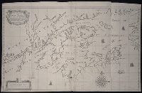
Map showing the communication of the lakes and the rivers between Lake Superior and Slave Lake in North America
Description:
"Gent. Mag. March 1790, Pl. I, p. 197" in upper right hand corner., Mounted on linen. Sheet measures 20.7 x 24.3 cm. Cross Collection no. 178., Prime meridian: London., and Relief shown by hachures.
Publisher:
s.n., 1790?]
Subject (Geographic):
Canada--Maps--Early works to 1800 and North America--Maps--Early works to 1800
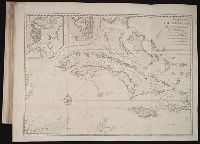
The English pilot: describing the sea-coasts, capes, head-lands, rivers, bays, roads, havens
Image Count:
1
Description:
Most maps numbered in pencil on verso, some on recto.
Subject (Geographic):
Atlantic Ocean --Maps --Early works to 1800, Canada --Maps --Early works to 1800, New England --Maps --Early works to 1800, Newfoundland and Labrador --Maps --Early works to 1800, and Nova Scotia --Maps --Early works to 1800
Subject (Topic):
Navigation --Early works to 1800, Pilot guides --Atlantic Coast (U.S.) --Early works to 1800, and Pilot guides --Caribbean Area --Early works to 1800
Collection Created:
London : Printed for John Thornton, at the sign of the England, Scotland, and Ireland, in the Minories, and Richard Mount, at the Postern on Tower-Hill, 1698London : Printed for John Thornton, at the sign of the England, Scotland, and Ireland, in the Minories, and Richard Mount, at the Postern on Tower-Hill, 1698
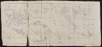
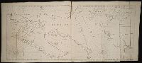
The English pilot: describing the West-India navigation, from Hudson's-Bay to the river Amazones
Image Count:
1
Subject (Geographic):
Atlantic Ocean --Maps --Early works to 1800, Cuba --Maps --Early works to 1800, Haiti --Maps --Early works to 1800, Hispaniola --Maps --Early works to 1800, Jamaica --Maps --Early works to 1800, and West Indies --Maps --Early works to 1800
Subject (Topic):
Navigation --Early works to 1800, Pilot guides --Atlantic Coast (U.S.) --Early works to 1800, and Pilot guides --Caribbean Area --Early works to 1800