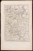
From Thomas Stackhouse's New history of the Holy Bible (London, 1752)., In lower left corner, "Pl. 3"; in lower right corner, "page 24.", Prime meridian: Ferro., Relief shown pictorially., and Watermark.
Publisher:
[Printed for John Hinton],
Subject (Geographic):
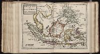
Middle East--Historical geography--Maps--Early works to 1800. and Middle East--Maps--Early works to 1800.
Subject (Name):
Hinton, John, -1781 and Stackhouse, Thomas, approximately 1680-1752. New history of the Holy Bible.
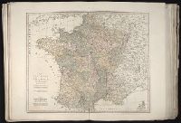
Also appeared in Kitchin's General atlas describing the whole universe. London : Printed Robert Sayer and J. Bennet, 1773; and General atlas describing the whole universe. London : Printed and sold for R. Sayer and J. Bennet, 1780., Ferro meridian., France divided into regions., From the map of Jaillot., No. 12 of 43 maps bound together in composite atlas., Relief shown pictorially., Scale [1:2,250,000]., and Shows boundaries, rivers, roads with distances and settlements.
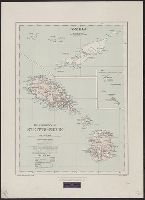
Principal islands in America belonging to the English empire viz Jamaica, Barbados, Antegoa, St. Christophers & Bermudos
Description:
[Antigua and Bermuda Islands] -- A general map of the Cariby Islands -- [Saint Kitts] -- [Barbados] -- The explanation of the marks on the island of Iamaica., Bar scale given in miles., No. 62 of 69 maps bound together in composite atlas., Relief shown pictorially., and Scales differ.
Publisher:
Sold by Phillip Lea at the Atlas and Hercules in Cheapside