Skip to search
Skip to main content
Skip to first result
Search
You Searched For
Genre
Maps
New Search
Search Results
Call Number:
MMLm143 778bc
Collection Title:
The self-interpreting Bible: containing the sacred text of the Old and New Testaments. Translated
Image Count:
5
Description:
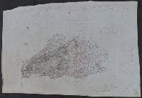
Binder’s title: Brown’s Bible. and Includes bound in map of the Holy Land (folded) 42 x 24 cm.
Subject (Topic):
Bible. O.T. and Palestine--Maps--Early works to 1800
Collection Created:
New-York : Printed by Hodge and Campbell, and sold at their respective book stores, M.DCC.XCII
Found in:
Beinecke Rare Book and Manuscript Library > [Selected pages]
Creator:
Published / Created:
[1850]
Call Number:
WA MSS 206
Collection Title:
Overland journey across the Plains to Oregon /by William H. Frush, 1850-1852
Image Count:
4
Abstract:
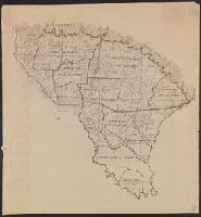
In 1850 Frush traveled from Missouri to Oregon by way of St. Joseph, Blue River, the North Platte, and Fort Laramie, where he met his brother John and Kit Carson. They continued by South Pass, Bear River, Soda Springs, Fort Hall, Fort Boise, the Dalles, and Portland. He records graves, the names and homes of other travelers, and ends his account with events in Oregon. The diary contains drawings of Chimney Rock, Court House Rock, profile of the Snake River, and a map of the Burnt River.
Subject (Geographic):
Oregon --Baker County --Maps, West (U.S.) --Description and travel, and West (U.S.) --Maps
Found in:
Beinecke Rare Book and Manuscript Library > [Selected pages]
Call Number:
1983 Folio 44
Collection Title:
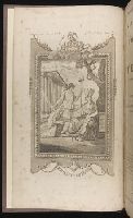
Isolario : descrittione geografico-historica, sacro-profana, antico-moderna, politica, naturale, e
Image Count:
3
Resource Type:
Books, Journals & Pamphlets
Subject (Geographic):
Lazzaretto Nuovo Island (Italy) and Murano (Italy)--Maps, Pictorial--Early works to 1800
Subject (Topic):
Geography --Early works to 1800 and Islands--Italy
Collection Created:
In Venetia : A’ spese dell’autore, 1696 [i.e. 1697]
Found in:
Beinecke Rare Book and Manuscript Library > [Selected pages]
Published / Created:
1801
Call Number:
57 N134 1801
Container / Volume:
BRBL_00304
Image Count:
2
Resource Type:
Maps, Atlases & Globes
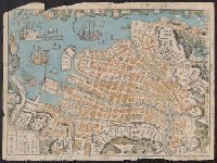
Description:
Woodcut Map, with printed coloring.
Subject (Geographic):
Japan--Maps
Found in:
Beinecke Rare Book and Manuscript Library > [Shinkan Nagasaki No Zu. (Newly engraved Map of Nagasaki)].
Published / Created:
1940?]
Call Number:
836gcg Sa585 1940
Container / Volume:
BRBL_00593
Image Count:
1
Resource Type:
Maps, Atlases & Globes
Alternative Title:
Map of portion of San Rafael Grazing District, Utah
Description:
Accompanied by note dating map in 1940, and annotated in black ink to indicate error on map., Relief shown by contours., and Title devised by cataloger.
Publisher:
s.n.,
Subject (Topic):
Grazing districts--Utah--Maps
Found in:
Beinecke Rare Book and Manuscript Library > [Shows proposed range management plan for a 194,000 acre area (unit 11B) of San Rafael Grazing District].
Creator:
Published / Created:
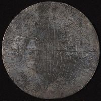
[1589]
Call Number:
Taylor 15
Image Count:
5
Resource Type:
Maps, Atlases & Globes
Description:
One of the medals without the cartouche bearing the engravers name: Micha. Merca.
Found in:
Beinecke Rare Book and Manuscript Library > [Silver map of the world showing the track of Sir Francis Drakes circumnavigation engraved or struck on a flat silver disc by Michael Mercator]
Published / Created:
185-?]
Call Number:
846hc 1850
Container / Volume:
BRBL_00624
Image Count:
1
Resource Type:
Maps, Atlases & Globes
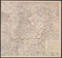
Description:
Relief shown by hachures and spot heights. and Shows route of company from Portland to Whitman Station (scene of Whitman Massacre); route from Whitman to Blue Mountains, escorting J.L. Meek's party; route in search of Cayuse Indians; scout through Palouse and Cayuse countries; route of detachment to Colville Agency; and return route from Whitman Station to Oregon City.
Publisher:
s.n.,
Subject (Geographic):
Oregon--Maps and Washington (State)--Maps
Found in:
Beinecke Rare Book and Manuscript Library > [Six route operations of a United States military company in Oregon Territory].
Published / Created:
1919.]
Call Number:
11hcf 1919A-6
Container / Volume:
BRBL_00010N
Image Count:
1
Resource Type:
Maps, Atlases & Globes
Description:
"EMGA, Cartog., no. 15."
Publisher:
EMGA,
Subject (Geographic):
France--Maps
Subject (Topic):
World War, 1914-1918--France--Maps
Found in:
Beinecke Rare Book and Manuscript Library > [Sketch map used by the French in discussions of Rhineland and French security.]
Published / Created:
[1930?]
Call Number:
766 M86 1930
Container / Volume:
BRBL_00711
Image Count:
1
Resource Type:
Maps, Atlases & Globes
Description:
Brown and black ink and pencil., Relief shown by contours., and Title supplied by cataloger.
Subject (Geographic):
Sleeping Giant State Park (Conn.)--Maps, Manuscript and Sleeping Giant State Park (Conn.)--Maps, Topographic
Subject (Topic):
Manuscript maps
Found in:
Beinecke Rare Book and Manuscript Library > [Sleeping Giant State Park, Conn.].
Published / Created:
191-.
Call Number:
11hc 1915R
Container / Volume:
BRBL_00010C
Image Count:
2
Resource Type:
Maps, Atlases & Globes
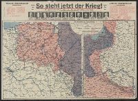
Description:
Includes 2 maps, text, and ill. and On verso: 4 anciallry maps, text, and ill.
Publisher:
Julius Hans Forkel,
Subject (Geographic):
Germany--Maps
Subject (Topic):
World War, 1914-1918--Maps
Found in:
Beinecke Rare Book and Manuscript Library > [So steht jetzt der Krieg!] : Kriegsoperationskarte über alle Kriegsschauplätze der welt.
Branch:v1.64.0 ,Deployed:2024-09-11T10:25:25-04:00