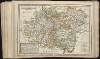
Twenty four new and accurate maps of the several parts of Europe ... : all (except the last) new
Image Count:
1
Alternative Title:
The south-west part of Germany, viz. Mentz and Treeves, Palatine of the Rhine, circles of Franconia, Swabia and Alsace, Lorain the Weteraw, &c
Description:
In pencil on verso: 11.
Subject (Geographic):
Alsace (France) --Maps, Franconia (Germany) --Maps, Germany --Maps --Early works to 1800, Lorraine (France) --Maps, Mainz (Rhineland-Palatinate, Germany) --Maps, Rhineland-Palatinate (Germany) --Maps, Swabia (Germany) --Maps --Early works to 1800, and Trier (Germany) --Maps
Subject (Name):
Barker, B. (Benjamin), d. 1764, bookseller, Clements, Henry, d. 1719, bookseller, King, Charles, d. 1735, bookseller, Nicholson, John, d. ca. 1717, bookseller, Parker, Richard, fl. 1692-1725, bookseller, and Tooke, Benjamin, d. 1716, bookseller
Subject (Topic):
Atlases --Early works to 1800
Collection Created:
[London] : Sold by J. Nicholson at the King’s-Arms in Little Britain, Benj. Barker and Charles King ..., Benj. Tooke ..., Hen. Clements ..., R. Parker and Ralph Smith under the Royal-Exchange ..., [1715?]
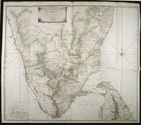
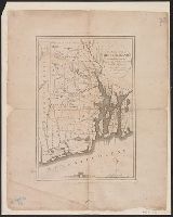
Map with relief shown pictorially, by hachures, and bathymetric soundings., No. 32 of 43 maps bound together in composite atlas., and Scale [ca. 1: 720 000].
Publisher:
Printed for Wm. Faden
Subject (Geographic):
India, South --History, Military --Maps --Early works to 1800
National Geographic Society (U.S.). Cartographic Section
Published / Created:
1940
Call Number:
7821 1940
Container / Volume:
BRBL_00506
Image Count:
1
Resource Type:
Maps, Atlases & Globes
Description:
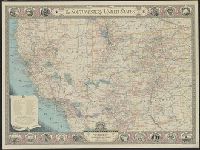
Copyright: The National Geographic Society., Includes index of routes of exploration, text and ill. of notable sites and events, and state seals., Issued with the National geographic magazine, v. 77, no. 6, June 1940., and Relief shown by hachures and spot heigh
Publisher:
The Society,
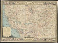
Subject (Geographic):
Southwest, New--Maps
Subject (Name):
A. Hoen & Co, Brehm, J. J, Chamberlin, Wellman, Darley, James M. (James Morrison), Eastwood, H. E, Holdstock, A. E, and Riddiford, Charles E
National Geographic Society (U.S.). Cartographic Section
Published / Created:
1940
Call Number:
7821 1940
Container / Volume:
BRBL_00506
Image Count:
1
Resource Type:
Maps, Atlases & Globes
Description:
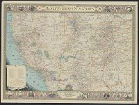
Copyright: The National Geographic Society., Includes index of routes of exploration, text and ill. of notable sites and events, and state seals., Issued with the National geographic magazine, v. 77, no. 6, June 1940., and Relief shown by hachures and spot heigh
Publisher:
The Society,
Subject (Geographic):
Southwest, New--Maps
Subject (Name):
A. Hoen & Co, Brehm, J. J, Chamberlin, Wellman, Darley, James M. (James Morrison), Eastwood, H. E, Holdstock, A. E, and Riddiford, Charles E
National Geographic Society (U.S.). Cartographic Section
Published / Created:
1940
Call Number:
7821 1940
Container / Volume:
BRBL_00506
Image Count:
1
Resource Type:
Maps, Atlases & Globes
Description:
Copyright: The National Geographic Society., Includes index of routes of exploration, text and ill. of notable sites and events, and state seals., Issued with the National geographic magazine, v. 77, no. 6, June 1940., Mounted on linen., and Relief shown by hachu
Publisher:
The Society,
Subject (Geographic):
Southwest, New--Maps
Subject (Name):
A. Hoen & Co, Brehm, J. J, Chamberlin, Wellman, Darley, James M. (James Morrison), Eastwood, H. E, Holdstock, A. E, and Riddiford, Charles E
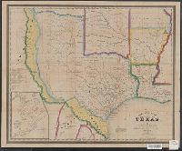
Includes population chart and index to ownership of electric railways., Inset: Map showing the lines of communication between New York, Boston and the West., and Relief shown by shading and spot heights.
"Entered according to Act of Congress, in the Year 1845, by R.S. Fisher, in the Clerks Office of the District Court of the Southern District of New York.", Includes distances table., and Inset: Plan of the Port of Galveston / made by order of the Mexican govern
Publisher:
R.S. Fisher,
Subject (Geographic):
Galveston Bay (Tex.)--Maps, Texas--Administrative and political divisions--Maps, and Texas--Maps