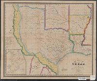
"Entered according to Act of Congress, in the Year 1845, by R.S. Fisher, in the Clerks Office of the District Court of the Southern District of New York.", Includes distances table., and Inset: Plan of the Port of Galveston / made by order of the Mexican govern
Publisher:
R.S. Fisher,
Subject (Geographic):
Galveston Bay (Tex.)--Maps, Texas--Administrative and political divisions--Maps, and Texas--Maps
Dominions of Turky in Europe in which are the governments of Romelia of the sea, of Buda, of Teme's war, and of Bosnia ... described by Sanson, corrected and amended by William Berry
Description:
Bar scales in Italian miles, common leagues of France, common leagues of Germany or great leagues of Poland, leagues of Hungary, and leagues that are of one hours travelling., Dedicated To the most serene and most sacred majesty Charles II ... by William Berry., No. 24 of 69 maps bound together in composite atlas., Relief shown pictorially., and Scale [ca. 1:3 500 000].
Publisher:
Sold by William Berry at the signe of the Globe between Charing-Cross and White-Hall
Subject (Geographic):
Balkan Peninsula --Maps --Early works to 1800, Italy --Maps --Early works to 1800, and Turkey --Maps --Early works to 1800
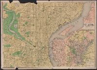
Below Baxter Springs: 1930., Below text: 13-4202., Includes text describing the land surface of Kansas and an inset of a geologic section of the state., and Relief shown by landform drawings.
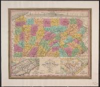
"Entered according to Act of Congress, April 15th, 1831 by S. Augustus Mitchell of the state of Pennsylvania.", Cover title in gold., Includes table of Pennsylvania population by counties, 1830, pasted inside front cover., and Insets: Profile of the Pennsylvania
Publisher:
Published by S. Augustus Mitchell,
Subject (Geographic):
Pennsylvania and Pennsylvania--Maps
Subject (Name):
Haines, D. and Mitchell, S. Augustus (Samuel Augustus), 1792-1868
Imperfect: Mutilated, with some loss of text. Ms. annotations., Index to places of interest and streets on verso., and Inset: Philadelphia and vicinity. Scale [ca. 1:116 000].
Bar scales given in English miles and Spanish leagues., Includes inset maps The Groyne, A general chart from England to Spain, Vigo and Bayonna, Porto, Lisbon and St. Ubes, and The harbour of Cadiz., No. 9 of 69 maps bound together in composite atlas., Relief shown pictorially., and Scale [ca. 1:1 800 000].
Publisher:
Sold by Christopher Browne at the Globe near the west end of St. Pauls Church