Skip to search
Skip to main content
Skip to first result
Search
You Searched For
Genre
Nautical charts
Subject (Topic)
Maps
Search Results
Creator:
Published / Created:
1752
Call Number:
2003 Folio 85
Image Count:
1
Resource Type:
cartographic image
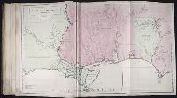
Description:
BEIN 2003 Folio 85: No. 25 of 45 maps bound together with binder's spine title: Atlas of America; ms. table of contents. Bookplate: Robinson. Bookplate of Paul Mellon.
Publisher:
Jean Baptiste Bourguignon d'Anville
Subject (Geographic):
Louisiana, Southern States, and Gulf of Mexico
Subject (Topic):
Maps and Nautical charts
Found in:
Beinecke Rare Book and Manuscript Library > Carte de la Louisiane
Creator:
Published / Created:
[1775?]
Call Number:
27 1775
Image Count:
1
Resource Type:
cartographic image
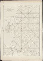
Description:
Depth shown by soundings.
Publisher:
Chez Demonville
Subject (Geographic):
Sunda Strait (Indonesia), Indonesia, and Sunda Strait.
Subject (Topic):
Maps and Nautical charts
Found in:
Beinecke Rare Book and Manuscript Library > Carte pour aller du détroit de la Sonde ou de Batavia au détroit de Banca
Creator:
Published / Created:
[ca. 1734]
Call Number:
1973 Folio 18
Image Count:
1
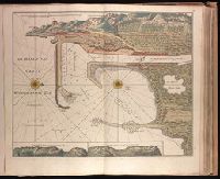
Description:
BEIN 1973 Folio 18: Backed with paper. Ms. no. "10" in upper right-hand corner. Sheet measures 53.5 x 62.5 cm. No. 9 of 87 maps bound together.
Publisher:
By Gerard van Keulen
Subject (Geographic):
Wismar (Germany), Germany, and Wismar Bay
Subject (Topic):
Maps and Nautical charts
Found in:
Beinecke Rare Book and Manuscript Library > De Haven en Stad Wismar desselfs Districkt Belegering en Werken daer voor [cartographic material].
Creator:
Published / Created:
[ca. 1734?]
Call Number:
1973 Folio 18
Image Count:
1
Description:
BEIN 1973 Folio 18: Backed with paper. Ms. no. "58" in upper right-hand corner. Sheet measures 53.7 x 62.3 cm. No. 53 of 87 maps bound together.
Publisher:
By Gerard van Keulen
Subject (Geographic):
Sète (France), France, and Sète
Subject (Topic):
Maps and Nautical charts
Found in:
Beinecke Rare Book and Manuscript Library > De Haven van Cette in de Middelandse Zee in Langedoc [cartographic material].
Creator:
Published / Created:
[1734]
Call Number:
1973 Folio 18
Image Count:
1
Description:
BEIN 1973 Folio 18: Backed with paper. Ms. no. "13" in upper right-hand corner. Sheet measures 53.6 x 35.5 cm. No. 13 of 87 maps bound together.
Publisher:
By Gerard van Keulen ...
Subject (Geographic):
Rügen Island (Germany), Stralsund (Germany), and Baltic Sea
Subject (Topic):
Northern War, 1700-1721, Maps, and Nautical charts
Found in:
Beinecke Rare Book and Manuscript Library > De kust van Pomeren, hey eyland Rugen [cartographic material].
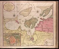
Creator:
Published / Created:
[ca. 1734]
Call Number:
1973 Folio 18
Image Count:
1
Alternative Title:
Haven en Stad Wismar
Description:
BEIN 1973 Folio 18: Backed with paper. Ms. no. "9" [partially trimmed] in upper right-hand corner. Sheet measures 53.5 x 62.5 cm. No. 8 of 87 maps bound together.
Publisher:
By Gerard van Keulen
Subject (Geographic):
Wismar (Germany), Germany, and Wismar Bay
Subject (Topic):
Maps and Nautical charts
Found in:
Beinecke Rare Book and Manuscript Library > Nieuwe afteekening van de Haven en Stad Wismar met desselfs inkoomende Zee Gaatten soo beoosten als bewesten Poel Eyland en beleegering van dito Stad. [cartographic material]
Creator:
Published / Created:
[1734]
Call Number:
1973 Folio 18
Image Count:
1
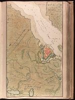
Description:
BEIN 1973 Folio 18: Backed with paper. Ms. no. "13" in upper right-hand corner. Sheet measures 53.6 x 62.8 cm. No. 12 of 87 maps bound together.
Publisher:
By Gerard van Keulen ...
Subject (Geographic):
Rügen Island (Germany), Stralsund (Germany), and Baltic Sea
Subject (Topic):
Maps and Nautical charts
Found in:
Beinecke Rare Book and Manuscript Library > Nieuwe afteekening van het eyland Rugen en de Straalsond als mede de stad Straalsond en t Nieuwe diep met alle desselfs gelegentheden int groot. [cartographic material]
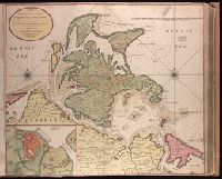
Creator:
Published / Created:
[ca. 1720?]
Call Number:
1973 Folio 18
Image Count:
1
Description:
BEIN 1973 Folio 18: Backed with paper. Ms. no. "66" in upper right-hand corner. Sheet measures 53.7 x 62.3 cm. No. 61 of 87 maps bound together.
Publisher:
By Gerard van Keulen, aen de nieuwe Brug met privilegie
Subject (Geographic):
Sardinia (Italy) and Mediterranean Sea
Subject (Topic):
Maps and Nautical charts
Found in:
Beinecke Rare Book and Manuscript Library > Nieuwe en nette afteekening van het eyland of Koninkryk Sardinia vertoonende alle desselfs zee havenen anker plaetsen rivieren dieptens klippen steeden en vastigheeen als mede de Straet van Bonifacio aent eyland Corsica [cartographic material]
Creator:
Published / Created:
[ca. 1734]
Call Number:
1973 Folio 18
Image Count:
1
Description:
BEIN 1973 Folio 18: Backed with paper. Ms. no. "43" in upper right-hand corner. Sheet measures 53.7 x 62.9 cm. No. 41 of 87 maps bound together.
Publisher:
By Ioannes van Keulen ...
Subject (Geographic):
West Frisian Islands (Netherlands), Netherlands, and West Frisian Islands
Subject (Topic):
Maps and Nautical charts
Found in:
Beinecke Rare Book and Manuscript Library > Nieuwe pascaert waar in te sien is de gaten van Texel en 't Vlie met alle syn mercken, diepte en droogte / [cartographic material]
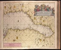
Creator:
Published / Created:
[ca. 1734]
Call Number:
1973 Folio 18
Image Count:
1
Alternative Title:
Noord-Bodem
Description:
BEIN 1973 Folio 18: Backed with paper. Ms. no. "14" in upper right-hand corner. Sheet measures 53.6 x 62.5 cm. No. 14 of 87 maps bound together.
Publisher:
By Johannes van Keulen ...
Subject (Geographic):
Finland, Sweden, and Bothnia, Gulf of
Subject (Topic):
Maps and Nautical charts
Found in:
Beinecke Rare Book and Manuscript Library > Nieuwe paskaart van de Noord-Bodem beginnende aen de Oost Zÿde van Abo tot Torne en aen de West-kant van Torne tot Gafle / [cartographic material]