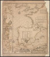
Peninsula and Gulf of Florida or Channel of Bahama with the Bahama Islands
Description:
"DG.4.", From Jefferys's The American atlas ... London : Printed and sold by R. Sayer and J. Bennett, 1776., Pictorial map, and Relief shown pictorially. Soundings shown in fathoms. "The soundings along the Florida coast, shoals, islands, and reefs are in feet."
Publisher:
Printed for Robt. Sayer, map and printseller ...,
Subject (Geographic):
Bahamas--Maps--Early works to 1800, Gulf Coast (Fla.)--Maps--Early works to 1800, and Gulf Coast (La.)--Maps--Early works to 1800
Subject (Name):
Jefferys, Thomas, d. 1771. American atlas and Sayer, Robert, 1725-1794
Peninsula and Gulf of Florida or Channel of Bahama with the Bahama Islands.
Description:
From Jefferys's The American atlas ... London : Printed and sold by R. Sayer and J. Bennett, 1776., Imperfect: detached along folds, with no loss of text. Sheets pasted together to form 1 sheet. Sheets measure 54 x 64 cm. and 54 x 66 cm., and Pictorial map.
Publisher:
Printed for Robt. Sayer, map and printseller ...,
Subject (Geographic):
Bahamas--Maps--Early works to 1800, Gulf Coast (Fla.)--Maps--Early works to 1800, and Gulf Coast (La.)--Maps--Early works to 1800
Subject (Name):
Jefferys, Thomas, d. 1771. American atlas and Sayer, Robert, 1725-1794
Atlas des Indes Occidentales. and The North American pilot.
Description:
From: The North American pilot. London, 1778-1779. Vol. 2, no. 13., Imperfect: chipped and torn, with no loss of text. Joined with Jeffrey's Island of Cuba with part of the Bahama banks & the Martyrs., Prime meridians: Ferro and London, Relief shown pictorially. Depths shown pictorially and by soundings., and Shows soundings, shoals and sailing channels.
Publisher:
Printed for Robt. Sayer, map & printseller, no. 53 Fleet Street, as the act directs,
Subject (Geographic):
Mexico, Gulf of--Maps--Early works to 1800, Yucatán Channel--Maps--Early works to 1800, and Yucatán Peninsula--Maps--Early works to 1800
Subject (Name):
Sayer, Robert, 1725-1794, publisher
Subject (Topic):
Nautical charts--Mexico, Gulf of--Early works to 1800 and Nautical charts--Yucatán Channel--Early works to 1800
Coast chart. ; no. 1 and From Point Judith to Cape Lookout
Description:
"Additions to 1861"., "Entered according to Act of Congress, in the year 1854, by E. & G.W. Blunt, in the Clerk's office of the District Court in the Southern D, and Inlcudes information on types of lights/lighthouses, currents, and magnetic compass variations.
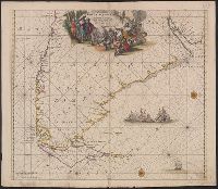
Cuba with part of the Bahama banks & the Martyrs and The North American pilot.
Description:
From: The North American pilot. London, 1778-1779. Vol. 2, no. 13., Imperfect: chipped and torn, with no loss of text. Joined with Jeffrey's Coast of Yucatán from Campeche to Baha del Ascencion, with the west end of Cuba., Prime meridians: Ferro and London., Relief shown pictorially. Depths shown by soundings and shading., and Shows towns and roads in Cuba (except easternmost and westernmost parts) and part of Bahamas and Florida Keys.
Publisher:
Printed for Robt. Sayer,
Subject (Geographic):
Bahamas--Maps--Early works to 1800, Cuba--Maps--Early works to 1800, and Florida Keys (Fla.)--Maps--Early works to 1800
"Emanl. Bowen sculp." and Insets: Plan of the Harbours of Ferrol and the Groyne -- Plan of St Sebastian -- Plan of Barcelona -- Plan of the Bay and City of Cadiz -- Plan of
Publisher:
T. Jefferys,
Subject (Name):
Bowen, Emanuel, d. 1767
Subject (Topic):
Coasts--Europe, Western--Maps--Early works to 1800 and Nautical charts--Europe, Western--Early works to 1800
Vidal, A. T. E. (Alexander Thomas Emeric), 1792-1863, author
Call Number:
655 1827
Container / Volume:
BRBL_00345
Image Count:
1
Resource Type:
Maps, Atlases & Globes
Description:
Depths shown by isolines and soundings., Manuscript annotations on verso. Manuscript number in upper left corner: 666., Prime meridian: Greenwich., and Relief shown by hachures and spot heights.
Subject (Geographic):
Atlantic Coast (Africa)--Maps and South Atlantic Ocean--Navigation
Subject (Name):
Great Britain. Hydrographic Office, publisher, J. & C. Walker (Firm), engraver, Mudge, William, 1762-1820, and Owen, W. F. W., 1774-1857
European possessions shown by color., Includes acknowledgement to Captain Speer by "John Pownall, secry., Plantation Office, Whitehall, January 25, 1774" and "Honorary gold medal.", Relief shown pictorially. Depths shown by sou, and Sheet measures 75 x 118.2 cm.
Publisher:
Capt. Speer,
Subject (Geographic):
Caribbean Area--Maps--Early works to 1800 and West Indies--Maps--Early works to 1800
Nieuwe perfecte pascaert van t' Suyderlyckste deel van Suyt America van Rio de la Plata door de straet Magellaen tot Toral
Description:
Appears in Wit's Orbis Maritimus ofte Zee Atlas., Bar scales in "Geometrische of Duytsche Mylen ...," and "France Mylen ... miliaria Gallica.", Cross Collection no. 333., and Title in ms. on verso, with ms. no. 160.
Publisher:
Frederick de Wit,
Subject (Geographic):
Magellan, Strait of (Chile and Argentina)--Maps--Early works to 1800 and South America--Maps--Early works to 1800
Subject (Name):
Wit, Frederik de. Orbis Maritimus ofte Zee Atlas
Subject (Topic):
Coasts--South America--Maps--Early works to 1800 and Nautical charts--Magellan, Strait of (Chile and Argentina)--Maps--Early works to 1800
Series B, Wind and current charts, Wind and current chart, Wind and current chart, trade wind chart of the Atlantic Ocean, Wind and current charts, Wind and current charts, trade wind chart of the Atlantic Ocean, and Wind and current charts.
Description:
"Lith. of J. Bien. 180 Broadway. N.Y." and The trade wind charts were released as series B of Maury's "Wind and current charts", series A-F. Two sheets were produced, one for the Atlantic and the other for the Indian Ocean. For complete discussion, see "The w
Publisher:
s.n.],
Subject (Geographic):
Atlantic Ocean--Maps
Subject (Name):
Dehaven, E. J, Maury, Matthew Fontaine, 1802-1873. Wind and current charts, and United States. Bureau of Ordnance and Hydrography
Subject (Topic):
Nautical charts--Atlantic Ocean, Trade winds--Atlantic Ocean--Maps, and Winds--Atlantic Ocean--Maps