Skip to search
Skip to main content
Skip to first result
Search
You Searched For
Language
English
Subject Heading
Middle Atlantic States
Search Results
Creator:
Published / Created:
1787.
Call Number:
1977 Folio 177
Image Count:
2
Description:
BEIN 1977 Folio 177: Sheet measures 66.3 x 60.3 cm. No. 1 of 34 maps bound together.
Publisher:
John Stockdale
Subject (Geographic):
Middle Atlantic States
Found in:
Beinecke Rare Book and Manuscript Library > A map of the country between Albemarle Sound, and Lake Erie comprehending the whole of Virginia, Maryland, Delaware and Pensylvania, with parts of several other of the United States of America / [cartographic material]
Creator:
Published / Created:
[1755]
Call Number:
2003 Folio 85
Image Count:
1
Description:
BEIN 2003 Folio 85: No. 21 of 45 maps bound together with binder's spine title: Atlas of America; ms. table of contents. Bookplate: Robinson. Bookplate of Paul Mellon.
Publisher:
Thos. Jeffreys
Subject (Geographic):
Virginia, Maryland, and Middle Atlantic States
Subject (Topic):
Maps
Found in:
Beinecke Rare Book and Manuscript Library > A map of the most inhabited part of Virginia containing the whole province of Maryland : with part of Pensilvania, New Jersey and North Carolina
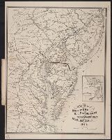
Creator:
Published / Created:
1874.
Call Number:
754gme 1874
Image Count:
1
Resource Type:
cartographic image
Alternative Title:
Map of the Baltimore, Chesapeake and Delaware Bay Railroad
Description:
Shows railroads and ferry routes.
Publisher:
J.L. Smith, map publisher, 27 South 6th Street
Subject (Geographic):
Middle Atlantic States
Subject (Name):
Baltimore, Chesapeake and Delaware Bay Railroad Company.
Subject (Topic):
Railroads
Found in:
Beinecke Rare Book and Manuscript Library > Map of the Baltimore, Chesapeake & Delaware Bay Railroad