Skip to search
Skip to main content
Skip to first result
Search
You Searched For
Language
French
Subject (Geographic)
Paris (France)--Maps
Search Results
Creator:
Published / Created:
[between 1916 and 1918?]
Call Number:
38 P21 1918
Container / Volume:
BRBL_00164A
Image Count:
1
Resource Type:
Maps, Atlases & Globes
Alternative Title:
Nouveau plan de Paris et banlieue
Description:
"Imp. sur zinc, Monrocq, Paris.", Map shows streets, existing Metro lines, Metro lines under construction, "Ligne Nord-Sud," parks, and other points of interest in Paris., and National Library of France gives date as 1916. Handwritten note on map gives date as
Publisher:
E. Blondel la Rougery,
Subject (Geographic):
Paris (France)--Maps
Found in:
Beinecke Rare Book and Manuscript Library > Carte Campbell [cartographic material] : Nouveau plan de Paris et banlieue : Indiquant toutes les voies nouvelles ainsi que les lignes du Métropolitain et Nord-Sud exploitées ou en construction / Ed. Blondel la Rougery.
Published / Created:
[1921]
Call Number:
38 P21 1921
Container / Volume:
BRBL_00164A
Image Count:
1
Resource Type:
Maps, Atlases & Globes
Description:
"4-21"--Bottom right., Inset: Sorties de Paris., and Relief shown by spot heights.
Publisher:
A. Taride, éditeur,
Subject (Geographic):
Paris (France)--Maps and Paris Region (France)--Maps
Subject (Name):
Cartes Taride (Firm), publisher
Found in:
Beinecke Rare Book and Manuscript Library > Carte des environs de Paris, échelle du 1/50.000e [cartographic material] : à l'usage des cyclistes, automobilistes, touristes, etc. / P. Bineteau, del.
Published / Created:
1912
Call Number:
38gme P21 1912A
Container / Volume:
BRBL_00171
Image Count:
1
Resource Type:
Maps, Atlases & Globes
Description:
In lower left margin: "Juin 1912"
Subject (Geographic):
Paris (France)--Maps
Found in:
Beinecke Rare Book and Manuscript Library > Carte du Départment de la Seine [cartographic material] : réseaux de tramways.
Published / Created:
1887
Call Number:
38 P21 1887
Container / Volume:
BRBL_00164
Image Count:
1
Resource Type:
Maps, Atlases & Globes
Description:
Flle. 15. Neuilly and Flle. 16. Pantin only. Two sheets mounted together on linen.
Publisher:
Service Géographique de l'Armeé,
Subject (Geographic):
Paris (France)--Maps and Paris Metropolitan Area (France)--Maps
Found in:
Beinecke Rare Book and Manuscript Library > Environs de Paris à 1:20.000.
Published / Created:
1856
Call Number:
38 P21 1856A
Container / Volume:
BRBL_00163
Image Count:
1
Resource Type:
Maps, Atlases & Globes
Publisher:
J. Andrive au-Goujon,
Subject (Geographic):
Paris (France)--Maps
Found in:
Beinecke Rare Book and Manuscript Library > Environs de Paris, d'après la nouvelle carte de France dressée au Dépot de la Guerre / Le trait gravé par Piat ... ; la lettre par Rousset ; imp. par Louis Antoine.
Published / Created:
1864
Call Number:
38 P21 1864
Container / Volume:
BRBL_00163
Image Count:
1
Resource Type:
Maps, Atlases & Globes
Description:
Dissected and mounted on linen.
Publisher:
Logerot, éditeur,
Subject (Geographic):
Paris (France)--Maps
Found in:
Beinecke Rare Book and Manuscript Library > Le Nouveau guide de l'étranger dans les 20 arrondissements de Paris.
Creator:
Published / Created:
1873
Call Number:
38 P21 1873A
Container / Volume:
BRBL_00163
Image Count:
1
Resource Type:
Maps, Atlases & Globes
Description:
Inset: Fortifications et environs de Paris.
Publisher:
Gravé par A. Martin,
Subject (Geographic):
Paris (France)--Maps
Found in:
Beinecke Rare Book and Manuscript Library > Le Plan de Paris de 1873 [cartographic material] / par le dr. Ermète Pierotti.
Creator:
Published / Created:
ca. 1900?]
Call Number:
38AM P21 1890B
Container / Volume:
BRBL_00168
Image Count:
2
Resource Type:
Maps, Atlases & Globes
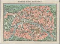
Alternative Title:
Monuments et vues des environs de Paris and Nouveau Paris monumental avec le parcours du métropolitain
Description:
On verso: Monuments et vues des environs de Paris., Perspective map., Relief shown pictorially., and Selected buildings and monuments shown pictorially.
Publisher:
s.n.,
Subject (Geographic):
Paris (France)--Maps and Paris Metropolitan Area (France)--Maps
Subject (Name):
Dufrénoy (Firm)
Subject (Topic):
Historic buildings--France--Paris--Maps
Found in:
Beinecke Rare Book and Manuscript Library > Nouveau Paris monumental [cartographic material] : Itinéraire pratique de l'étranger dans Paris / gravé par L. Poulmaire.
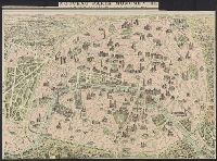
Creator:
Published / Created:
[1900?]
Call Number:
38AM P21 1900
Container / Volume:
BRBL_00168
Image Count:
1
Resource Type:
Maps, Atlases & Globes
Alternative Title:
Itinéraire pratique de l'étranger dans Paris
Description:
Also shows subway lines in use and under construction., Imperfect: bled along edges. Not mounted on linen., In French., and Selected buildings shown pictorially.
Publisher:
Garnier Frères,
Subject (Geographic):
Paris (France)--Maps and Paris Metropolitan Area (France)--Maps
Subject (Name):
Dufrénoy (Firm) and Poulmaire, L
Subject (Topic):
Monuments--France--Paris--Maps, Subways--France--Paris--Maps, and Tourism--France--Paris--Maps
Found in:
Beinecke Rare Book and Manuscript Library > Nouveau Paris monumental [cartographic material] : itinéraire pratique de l'étranger dans Paris / Garnier-Frères, libraires-éditeurs ; gravé par L. Poulmaire.
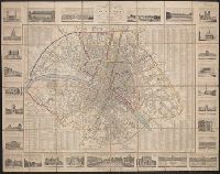
Published / Created:
1829
Call Number:
38 P21 1829
Container / Volume:
BRBL_00162
Image Count:
1
Resource Type:
Maps, Atlases & Globes
Description:
Index to names and border of views on margins of map.
Publisher:
Chez Le Roi, Libraire,
Subject (Geographic):
Paris (France)--Maps
Found in:
Beinecke Rare Book and Manuscript Library > Nouveau Plan Routier de la Ville de Paris ...
Branch:v1.68.1 ,Deployed:2025-05-28T09:32:28-04:00