Skip to search
Skip to main content
Skip to first result
Search
You Searched For
Language
German
Subject (Name)
Justus Perthes (Firm : Gotha, Germany)
Search Results
Creator:
Published / Created:
1891
Call Number:
44 1891A
Container / Volume:
BRBL_00255
Image Count:
1
Resource Type:
Maps, Atlases & Globes
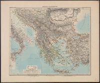
Description:
"Stieler's Hand-Atlas, No. 50."
Publisher:
Justus Perthes,
Subject (Geographic):
Balkan Peninsula--Maps
Subject (Name):
Justus Perthes (Firm : Gotha, Germany)
Found in:
Beinecke Rare Book and Manuscript Library > Balkan-Halbinsel / Entworfen v. C. Vogel ; bearbeitet von Dr. R. Lüddecke.
Creator:
Published / Created:
1861
Call Number:
63 1861
Container / Volume:
BRBL_00334
Image Count:
1
Resource Type:
Maps, Atlases & Globes
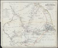
Alternative Title:
Ost-Afrika zwischen Chartúm & dem Rothen Meere
Description:
Includes text.
Publisher:
Justus Perthes,
Subject (Geographic):
Eritrea--Discovery and exploration--Maps, Ethiopia--Discovery and exploration--Maps, and Sudan--Discovery and exploration--Maps
Subject (Name):
Heuglin, Theodor von,--1824-1876 and Justus Perthes (Firm : Gotha, Germany)
Found in:
Beinecke Rare Book and Manuscript Library > Entwurf einer Karte von Ost-Afrika zwischen Chartúm & dem Rothen Meere, bis Sauakin und Massaua : nach allen vorhandenen Quellen entworfen von A. Petermann, zum Gebrauch der v. Heuglin'schen Expedition ausgeführt durch Justus Perthes' Geographisches Ans
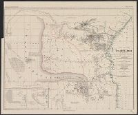
Creator:
Published / Created:
1875
Call Number:
36cbf 1875
Container / Volume:
BRBL_00127
Image Count:
1
Resource Type:
Maps, Atlases & Globes
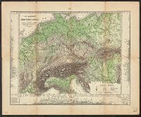
Description:
Includes mountain range profiles showing heights of selected peaks in margin.
Publisher:
Justus Perthes,
Subject (Geographic):
Europe--Maps and Germany--Maps
Subject (Name):
Berghaus, Hermann, 1828-1890 and Justus Perthes (Firm : Gotha, Germany)
Subject (Topic):
Mountains--Europe--Charts, diagrams, etc and Mountains--Germany--Charts, diagrams, etc
Found in:
Beinecke Rare Book and Manuscript Library > Fluss- und Bergkarte von Deutschland und den anliegenden Ländern / entworfen u. gez. von Adolf Stieler, 1820.
Creator:
Published / Created:
1904
Call Number:
38 1904
Container / Volume:
BRBL_00155
Image Count:
1
Resource Type:
Maps, Atlases & Globes
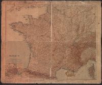
Description:
"Stielers Hand Atlas".
Publisher:
Justus Perthes,
Subject (Geographic):
France--Maps
Subject (Name):
Justus Perthes (Firm : Gotha, Germany)
Found in:
Beinecke Rare Book and Manuscript Library > Frankreich in 4 Blättern [cartographic material] / von C. Vogel ; gestochen, Schrift von H. Eberhardt, Terrain von W. Weiler.
Creator:
Published / Created:
1891
Call Number:
40 1891
Container / Volume:
BRBL_00202
Image Count:
1
Resource Type:
Maps, Atlases & Globes
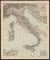
Description:
"Stieler's Hand-Atlas."
Publisher:
Justus Perthes,
Subject (Geographic):
Italy--Maps
Subject (Name):
Justus Perthes (Firm : Gotha, Germany)
Found in:
Beinecke Rare Book and Manuscript Library > Italien in 4 Blättern / von C. Vogel ; berichtigt von O. Koffmahn ; gest. v. Kühn, Kern u. Weiler.
Creator:
Published / Created:
1870
Call Number:
36fab 1870
Container / Volume:
BRBL_00128
Image Count:
1
Resource Type:
Maps, Atlases & Globes
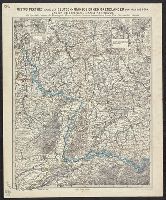
Alternative Title:
Karte der deutsch-französischen Grenzländer von Köln bis Bern und von Metz bis Ulm
Description:
"No. 1."
Publisher:
Perthes,
Subject (Geographic):
France--Boundaries--Germany--Maps and Germany--Boundaries--France--Maps
Subject (Name):
Justus Perthes (Firm : Gotha, Germany)
Found in:
Beinecke Rare Book and Manuscript Library > Justus Perthes' Karte der deutsch-französischen Grenzländer von Köln bis Bern und von Metz bis Ulm : mit Special-Cartons der Festungen Mainz, Saarlouis, Landau, Germersheim, Rastatt, Ulm / bearbeitet von C. Vogel.
Creator:
Published / Created:
1843
Call Number:
56 1843A
Container / Volume:
BRBL_00295
Image Count:
1
Resource Type:
Maps, Atlases & Globes
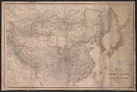
Description:
Imperfect: chipped, with some loss of text. Mounted on linen. Label affixed above title, "Library of th
Publisher:
Bei Justus Perthes,
Subject (Geographic):
China--Maps and Japan--Maps
Subject (Name):
American Oriental Society. Library Bookplate, Anville, Jean Baptiste Bourguignon d', 1697-1782, and Justus Perthes (Firm : Gotha, Germany)
Found in:
Beinecke Rare Book and Manuscript Library > Karte von China und Japan den Manen D'Anville's und Klapproth's [cartographic material] / gewidmet Potsdam von H.B.
Creator:
Published / Created:
1868
Call Number:
643 1868
Container / Volume:
BRBL_00339
Image Count:
1
Resource Type:
Maps, Atlases & Globes
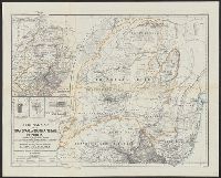
Alternative Title:
Ergänzungsheft ... zu Petermanns geographischen Mitteilungen. and Transvaal or South-African Republik
Description:
"From surveys and observations by Survr. Genl. M. Forssmann, C. Mauch, F. Hammar, Survr. J. Brooks, and other official documents, combined with the results of their own explorations by F. Jeppe and A. Merensky, Potchefstroom & Botsabelo, 1868."
Publisher:
Justus Perthes ,
Subject (Geographic):
South Africa--Maps and Swaziland--Maps
Subject (Name):
Justus Perthes (Firm : Gotha, Germany)
Found in:
Beinecke Rare Book and Manuscript Library > Original map of the Transvaal or South-African Republik / reconstructed and augmented with data from various exploring travellers &c. by A. Petermann.
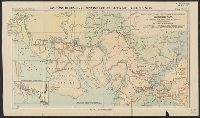
Creator:
Published / Created:
1902
Call Number:
6535 1902
Container / Volume:
BRBL_00343
Image Count:
1
Resource Type:
Maps, Atlases & Globes
Description:
"Langhans: Beiträge zur Kenntnis der deutschen Schutzgebiete, Nr. 18."
Publisher:
Justus Perthes,
Subject (Geographic):
Cameroon--Discovery and exploration--Maps
Subject (Name):
Justus Perthes (Firm : Gotha, Germany) and Ross, Alexander--Travel--Maps
Found in:
Beinecke Rare Book and Manuscript Library > Reisewege des Presbyterianer-Missionars Alexander Ross von Alt-Kalabar ins Kamerun-Gebiet, 1877 und 1878, nebst seinem Erkundigungen / von Paul Langhans.
Creator:
Published / Created:
1856
Call Number:
63 1856
Container / Volume:
BRBL_00334
Image Count:
1
Resource Type:
Maps, Atlases & Globes
Alternative Title:
Ost-u.-Central-Afrika and Petermanns geographische Mittheilungen.
Description:
"Gestützt auf die Angaben zahlreicher Eingebornen und muhamedanischer Reisenden und zusammengetragen von Jakob Erhardt u
Publisher:
Justus Perthes ,
Subject (Geographic):
Africa, East--Maps
Subject (Name):
Erhardt, Jakob, Justus Perthes (Firm : Gotha, Germany), and Rebmann, Johann
Subject (Topic):
Caravans--Africa, East--Maps
Found in:
Beinecke Rare Book and Manuscript Library > Skizze einer Karte eines Theils von Ost-u. Central-Afrika, mit Angabe der wahrscheinlichen Lage u. Ausdehnung des See's von Uniamesi, nebst Bezeichnung der Grenzen u. Wohnsitze der verschiedenen Völker, sowie der Caravanen-Strassen nach dem Innern / nach