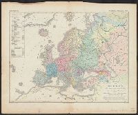
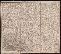
Copy 3: Imperfect: all sheets but C2, C3, and D3 wanting., Covers Europe from western France to eastern Russia, and from the North Sea to the Aegean Sea., and Relief shown by hachures and spot heights.
Covers Europe from western France to eastern Russia, and from the North Sea to the Aegean Sea., Includes sheet index., Introductory sheets include title, location map, glossary, and legend., Pronunciation guide and abbreviations in 8 languages., Relief shown by hachures and spot heights., and Sheet title and scale bars affixed to verso. Only sheet F.6 verso digitized as reference.
Copy 2: Imperfect: all sheets but C1, C2, D1, D2, E1 and E2 wanting., Covers Europe from western France to eastern Russia, and from the North Sea to the Aegean Sea., and Relief shown by hachures and spot heights.
"Photolitho: Berliner Lithographisches Institut, Berlin W 35". and 307 1942: Includes index map (using "Europe and the Near East, compiled and drawn in the Cartographic Section of the National Geographic Society" as base map).
Germany. Heer. Abteilung für Kriegskarten- und Vermessungswesen
Published / Created:
1941
Call Number:
539cbf 1941
Container / Volume:
BRBL_00289
Image Count:
1
Resource Type:
Maps, Atlases & Globes
Description:
"Anlage zu Mil.-Geo-Angaben über Afghanistan, Baluchistan, Brit.-Ind. NW-Grenzprovinz.", "Grundkartenwerk: Southern Asia series 1:2 000 000.", "IX.41 (D 73).", "Nur für den Dienstgebrauch.", and Relief shown by gradient tints and spot heights.
Publisher:
Abteilung für Kriegskarten- und Vermessungswesen],
Subject (Geographic):
Afghanistan--Maps and Balochistān (Pakistan)--Maps