I︠A︡kimova, M. A Soviet Union. Glavnoe upravlenie geodezii i kartografii
Published / Created:
1950
Call Number:
352cbf Ur1 1950
Container / Volume:
BRBL_00109
Image Count:
4
Resource Type:
Maps, Atlases & Globes
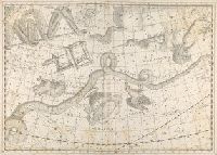
Description:
"V-156.", Below imprint: Karta dli︠a︡ sredneĭ shkolʹī., In Russian., Relief shown by gradient tints and spot heights. Depths shown by bathymetric tints and soundings., and Shows relief and bathymetry, mineral resources, cities, boundaries, etc.
Publisher:
Glavnoe upravlenie geodezii i kartografii pri Sovete Ministrov SSSR,
Subject (Geographic):
Ural Mountains Region (Russia)--Maps
Subject (Topic):
Mines and mineral resources--Russia (Federation)--Ural Mountains Region--Maps