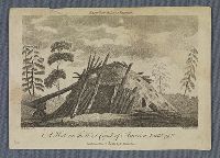
"A hut with a door at the front, with logs next to the door and in a pile in front of the hut to the right."--British Museum online catalogue
Description:
Title engraved below image., Sheet trimmed within plate mark., "Engrav'd for the Ladys Magazine"--Above image., and Plate from: The lady's magazine, or, Entertaining companion for the fair sex, v. 16 (February 1785).
Publisher:
Published March 1st, 1785, by G. Robinson
Subject (Geographic):
Alaska and Alaska.
Subject (Topic):
Discovery and exploration, Indians of North America, and Huts
Print shows a view of a settlement at Goulding's Harbor, a side channel of Portlock's Harbor between Sitka and Juneau in Alaska, visited by the ships King George and Queen Charlotte and Captains Portlock and Dixon. Two men holding rope, pulling small boat to shore; two other figures, Native persons, on opposite bank, with two small buildings; woods and rocky hillsides
Description:
BEIN BrSide4o Zc70 789vi: On sheet 18.3 x 23,0 cm. and Title from caption below image.
Publisher:
Publish'd by J. Stockdale & G. Goulding
Subject (Geographic):
Northwest Coast of North America and Alaska
Subject (Topic):
Indians of North America, Voyages around the world, and Discovery and exploration
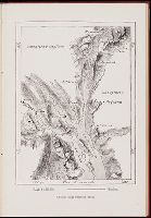
Atlas severozapadnykh beregov Ameriki ot Beringova proliva do mysa Korriėntes i ostrovov Aleutskikh s prisovokupleniem nekotorykh mest severovostochnago berega Azii, Gidrograficheskīi︠a︡ zami︠e︡chanīi︠a︡ kʺ atlasu si︠e︡verozapadnykhʺ beregovʺ Ameriki, ostrovovʺ Aleutskikhʺ i ni︠e︡kotorykhʺ drugikhʺ mi︠e︡stʺ Si︠e︡vernago Tikhago okeana, Gidrograficheskii︠a︡ zamechanii︠a︡ k atlasu severozapadnykh beregov Ameriki, ostrovov Aleutskikh i nekotorykh drugikh mest Severnogo Tikhogo okeana, Атлас северозападных берегов Америки от Берингова пролива до мыса Корриэнтес и островов Алеутских с присовокуплением некоторых мест северовосточнoго берега Азии, Гидрографическія замѣчанія къ атласу сѣверозападныхъ береговъ Америки, острововъ Алеутскихъ и нѣкоторыхъ другихъ мѣст Сѣвернаго Тихаго океана, and Гидрографическия замечания к атласу северозападных берегов Америки, островов Алеутских и некоторых других мест Севернoго Тихoго океана
Description:
BEIN EEga 852T: Printed label on inside front cover: Cat. [with manuscript 786]., Includes table of contents for 38 maps (the initial map is unnumbered)., and Accompanied by: Gidrograficheskīi︠a︡ zami︠e︡chanīi︠a︡ k atlasu ... (Sanktpeterburg: Tip. Morskago korpusa, 1852). [4], 7, [1], 148, 17, [3] pages; 17 cm.
Publisher:
publisher not identified
Subject (Geographic):
Alaska, California, Pacific Coast (North America), Asia, Pacific Coast., Alaska., California., and North America
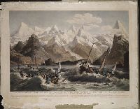
BEIN BrSides Elephant Folio Zc86 800cr: Imperfect: chipped and torn along edges. Backed with paper., Engraving showing the shipwreck of two small boats that were part of the La Perouse Expedition, during their reconnaissance of Lituya Bay, near Juneau, Alaska., and "Deposé à Bibliotheque Imperiale."
Publisher:
Chez Ostervald l'ain Rue du petit Lion St. Sulpice, No. 20 and Imprimé par Bassand
Subject (Geographic):
Alaska
Subject (Name):
La Pérouse, Jean-François de Galaup, comte de, 1741-1788